Weather
Quick Hit Of Snow Will Disrupt Milwaukee's Morning Commute: WI Weather
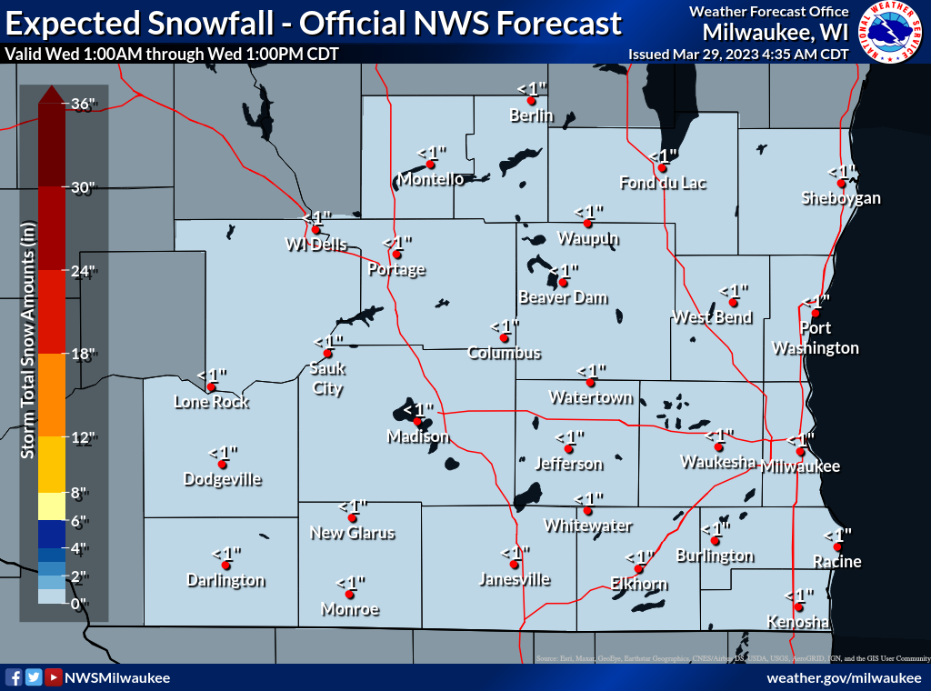
"Light snow showers will affect the morning rush hour as a cold front moves south," the National Weather Service said.


MILWAUKEE — Commuters in the Milwaukee metro should be prepared for a quick hit of snow during the Wednesday morning rush hour.
"Light snow showers will affect the morning rush hour as a cold front moves south across southern Wisconsin," the National Weather Service said.
"While snow will not last long (1-2 hours in any one location), a few tenths of accumulation is expected. Be prepared for varying visibility and road conditions. Snow should exit to the south after 9 AM."
Find out what's happening in Milwaukeefor free with the latest updates from Patch.
Thursday and Friday will feature rain and possible thunderstorms. However, the rain will change into snow Friday night into early Saturday morning.
Here's the specific NWS forecast from the Milwaukee Mitchell International Airport:
Find out what's happening in Milwaukeefor free with the latest updates from Patch.
Wednesday: A 40 percent chance of snow, mainly between 7am and 9am. Cloudy through mid morning, then gradual clearing, with a high near 35. Northwest wind 10 to 15 mph.
Wednesday Night: Mostly clear, with a low around 24. Northwest wind around 5 mph becoming calm after midnight.
Thursday: A 30 percent chance of rain after 4pm. Increasing clouds, with a high near 41. Southeast wind 5 to 15 mph.
Thursday Night: A chance of rain before 1am, then rain likely and possibly a thunderstorm between 1am and 4am, then rain likely after 4am. Mostly cloudy, with a temperature rising to around 47 by 3am. Windy, with a south wind 15 to 20 mph increasing to 20 to 25 mph after midnight. Winds could gust as high as 40 mph. Chance of precipitation is 70%. New rainfall amounts between a tenth and quarter of an inch, except higher amounts possible in thunderstorms.
Friday: A chance of rain before 7am, then a chance of rain and thunderstorms between 7am and 1pm, then rain and possibly a thunderstorm after 1pm. High near 59. Breezy, with a southwest wind 15 to 20 mph, with gusts as high as 35 mph. Chance of precipitation is 90%. New rainfall amounts between a quarter and half of an inch possible.
Friday Night: Rain before 4am, then snow likely, possibly mixed with rain. Some thunder is also possible. Low around 31. Windy, with a south wind 25 to 30 mph becoming west after midnight. Winds could gust as high as 45 mph. Chance of precipitation is 90%. New snow accumulation of less than a half inch possible.
Saturday: Snow likely, possibly mixed with rain before 7am, then a slight chance of snow between 7am and 1pm. Partly sunny, with a high near 41. Windy, with a northwest wind 25 to 30 mph decreasing to 15 to 20 mph in the afternoon. Winds could gust as high as 45 mph. Chance of precipitation is 60%. New precipitation amounts of less than a tenth of an inch possible.
Saturday Night: Mostly clear, with a low around 28. North wind 5 to 10 mph becoming south after midnight.
Sunday: Mostly sunny, with a high near 53. Breezy.
Sunday Night: Partly cloudy, with a low around 41.
Monday: A 20 percent chance of rain. Partly sunny, with a high near 52.
Monday Night: A 40 percent chance of rain. Mostly cloudy, with a low around 38.
Tuesday: A 50 percent chance of rain. Partly sunny, with a high near 55. Breezy.
Get more local news delivered straight to your inbox. Sign up for free Patch newsletters and alerts.