Weather
Snow In Milwaukee Possible This Week After Warm Start
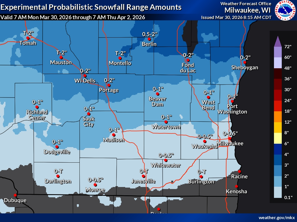
Rain may change to snow Wednesday, with up to a half-inch possible in Milwaukee

MILWAUKEE, WI — A burst of spring warmth will give way to a midweek cooldown that could bring snow to the Milwaukee area, according to the National Weather Service.
Forecasters say a rain-to-snow transition is possible Wednesday into Wednesday night as temperatures fall into the 30s.
In Milwaukee, snow totals are expected to stay on the lighter side, generally up to around a half inch. Areas just inland, including Waukesha County, could see similar amounts.
Find out what's happening in Milwaukeefor free with the latest updates from Patch.
Higher totals are possible farther north and west, where some communities could pick up 1 to 2 inches of snow.
The snow comes after a warm start to the week, with highs climbing into the 60s Monday and near 60 Tuesday before dropping sharply by Wednesday.
Find out what's happening in Milwaukeefor free with the latest updates from Patch.
While accumulations look minor, the timing and colder temperatures could still create slick spots on roads, especially Wednesday night into early Thursday.
Rain is expected to take over again Thursday, with a soaking system bringing up to an inch of precipitation before unsettled weather lingers into the weekend.
The brief return to snow highlights a classic Upper Midwest spring pattern, where winter conditions can quickly follow a stretch of warm weather.
Here's the full NWS forecast from the Milwaukee Airport:
Today: Mostly sunny, with a high near 65. Southwest wind 5 to 10 mph becoming east in the afternoon.
Tonight: A 50 percent chance of rain and thunderstorms, mainly before 1am. Mostly cloudy, with a low around 43. Northeast wind around 5 mph becoming north in the evening.
Tuesday: A chance of rain and thunderstorms before 1pm, then rain and possibly a thunderstorm between 1pm and 4pm, then a chance of rain and thunderstorms after 4pm. High near 60. East wind 5 to 10 mph becoming west in the morning. Chance of precipitation is 80%. New rainfall amounts between a quarter and half of an inch possible.
Tuesday Night: A chance of rain and thunderstorms before 7pm, then a chance of rain between 7pm and 1am. Mostly cloudy, with a low around 33. North wind around 10 mph. Chance of precipitation is 30%.
Wednesday: A chance of snow after 1pm, mixing with rain after 4pm. Mostly cloudy, with a high near 40. Northeast wind 10 to 15 mph, with gusts as high as 25 mph. Chance of precipitation is 30%.
Wednesday Night: Rain, possibly mixed with snow, becoming all rain after 4am. Low around 33. East wind around 15 mph, with gusts as high as 30 mph. Chance of precipitation is 90%. New snow accumulation of less than a half inch possible.
Thursday: Rain. High near 48. Northeast wind around 15 mph, with gusts as high as 25 mph. Chance of precipitation is 90%. New precipitation amounts between three quarters and one inch possible.
Thursday Night: Rain likely, mainly before 1am. Cloudy, with a low around 38. Northeast wind 10 to 15 mph becoming northwest after midnight. Chance of precipitation is 70%. New precipitation amounts between a tenth and quarter of an inch possible.
Friday: A 20 percent chance of rain after 1pm. Mostly cloudy, with a high near 47.
Friday Night: Rain likely, mainly after 1am. Mostly cloudy, with a low around 37. Chance of precipitation is 60%.SaturdayRain likely. Cloudy, with a high near 54. Chance of precipitation is 60%.
Saturday Night: A 40 percent chance of rain. Mostly cloudy, with a low around 34.
Sunday: Mostly cloudy, with a high near 46.
Get more local news delivered straight to your inbox. Sign up for free Patch newsletters and alerts.