Weather
Wind Chills Plunge To 40 Below As Extreme Cold Grips Wisconsin
Wind chills between -30 and -40 are expected Friday before slightly milder, but still dangerous, cold follows.

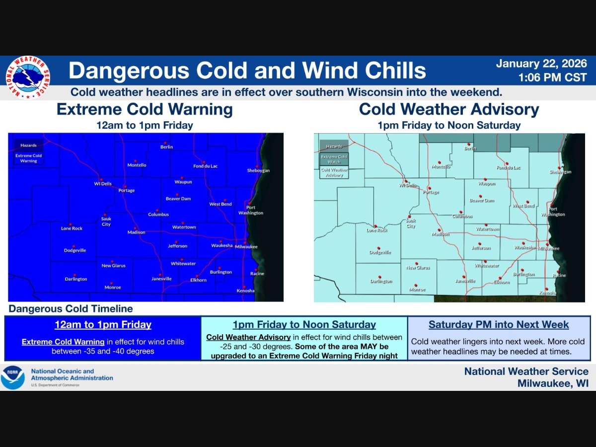
MILWAUKEE, WI — A dangerous blast of Arctic air is gripping southeastern Wisconsin, with wind chills plunging as low as 40 degrees below zero overnight and into Friday, prompting an Extreme Cold Warning for much of the region.
According to the National Weather Service, the Extreme Cold Warning is in effect from midnight until 1 p.m. Friday, with wind chills expected to range from -30 to -40 degrees. Air temperatures during the warning period will generally sit between -10 and -20 degrees.
Following the warning, a Cold Weather Advisory will take effect from 1 p.m. Friday through noon Saturday, as wind chills remain dangerously cold between -20 and -30 degrees.
Find out what's happening in Milwaukeefor free with the latest updates from Patch.
As of Thursday evening, conditions at Milwaukee’s General Mitchell International Airport showed temperatures near 13 degrees, but strong west winds were already driving wind chills below zero. Forecasters say conditions will deteriorate rapidly overnight.
Tonight, temperatures are expected to fall to around -15 degrees, with northwest winds gusting up to 35 mph. Wind chills between -30 and -40 degrees are likely through Friday morning and afternoon, even under mostly sunny skies.
Find out what's happening in Milwaukeefor free with the latest updates from Patch.
Friday’s high temperature is forecast to reach only about -4 degrees, with little relief from the wind. Conditions will remain hazardous for anyone spending extended time outdoors.
Friday night, wind chills may ease slightly into the -20 to -25 degree range as winds weaken, but dangerously cold conditions will persist. A gradual moderation is expected over the weekend, though temperatures will remain well below normal.
Saturday highs are expected near 8 degrees, with wind chills still as low as -25 at times. Light snow chances return Saturday night and Sunday, with highs climbing into the teens. Cold weather is expected to linger into next week, with additional cold headlines possible.
Forecasters also cautioned that some areas may need to be added back into an Extreme Cold Warning Friday night, depending on how conditions evolve.
Officials urge residents to limit time outdoors, dress in layers, cover exposed skin, and check on vulnerable neighbors during the prolonged cold stretch.
Here's the full NWS forecast from the Milwaukee Airport:
Friday: Sunny and cold, with a high near -4. Wind chill values between -30 and -40. Northwest wind around 15 mph, with gusts as high as 30 mph.
Friday Night: Increasing clouds, with a low around -12. Wind chill values between -20 and -25. Northwest wind 5 to 10 mph.
Saturday: A 20 percent chance of snow. Mostly cloudy and cold, with a high near 8. Wind chill values between -15 and -25. Northwest wind around 5 mph.
Saturday Night: A 40 percent chance of snow. Cloudy, with a low around 3. Northeast wind around 5 mph.
Sunday: A 40 percent chance of snow. Mostly cloudy, with a high near 15. Northeast wind 5 to 10 mph.
Sunday Night: A 30 percent chance of snow, mainly before midnight. Mostly cloudy, with a low around -2. Northwest wind around 10 mph.
Monday: Mostly sunny and cold, with a high near 10. Northwest wind 10 to 15 mph.
Monday Night: Mostly cloudy, with a low around 3.
Tuesday: Partly sunny, with a high near 17.
Tuesday Night: Partly cloudy, with a low around 3.
Wednesday: A 20 percent chance of snow. Partly sunny, with a high near 13.
Wednesday Night: A 20 percent chance of snow. Partly cloudy, with a low around -1.
Thursday: A 20 percent chance of snow. Mostly sunny and cold, with a high near 10.
Get more local news delivered straight to your inbox. Sign up for free Patch newsletters and alerts.