Weather
Winter Storm Warning Issued for Wisconsin; 6-8 Inches of Snow Predicted
The National Weather Service has issued a Winter Storm Watch as a massive snow storm heads our way on Saturday. Here's what you should know:

WISCONSIN -- The National Weather Service has issued a Winter Storm Watch as a massive snow storm heads our way on Saturday.
5 Things to Know about This Storm:
- Timing: Snow is possible from 8 pm cst this evening through Sunday evening.
- Accumulation: Total snow accumulations of 6 to 8 inches are possible.
- Wind and Visibility: Southeast winds 10 to 15 mph with gusts to 20 mph causing drifting snow. Gusts to 25 mph are possible near lake Michigan causing areas of blowing snow. Visibility in snow as low as one half mile and possibly one quarter mile.
- Impacts: Hazardous travel conditions developing tonight continuing into Sunday.
- Precautionary/Preparedness Actions: A winter storm watch means there is a potential for significant snow, sleet or ice accumulations that may impact travel.
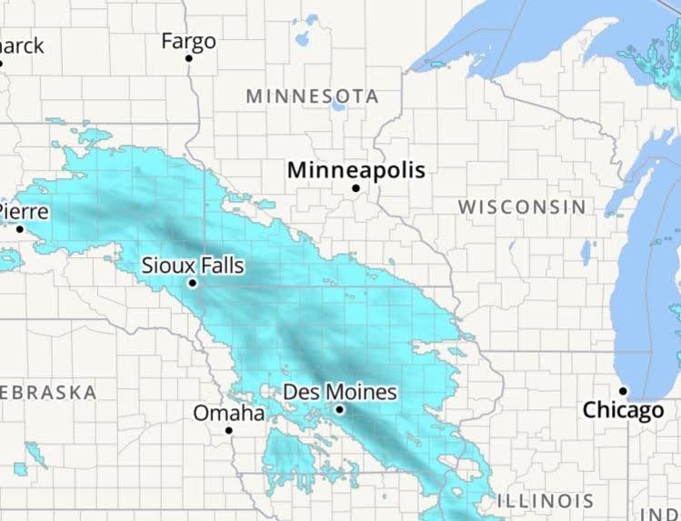
As of midday Saturday, snow is currently located across central and western Iowa, and is expected to spread northeast into south central Wisconsin late this afternoon and across the rest of southern Wisconsin this evening. The snow will continue into Sunday evening as low pressure moves across southern Wisconsin.
Find out what's happening in Milwaukeefor free with the latest updates from Patch.
By later Sunday night, snowfall of 6 to 9 inches will likely to have fallen across southern Wisconsin. Breezy southeast winds will also cause some drifting of the snow on Sunday. Breezy west winds will cause drifting late Sunday night into Monday morning.
Hazardous travel conditions will develop tonight and continue into Sunday night due to the accumulating snow and reduced visibility.
Find out what's happening in Milwaukeefor free with the latest updates from Patch.
>>> image via NWS
Get more local news delivered straight to your inbox. Sign up for free Patch newsletters and alerts.