Weather
Winter Storm Warnings, Watches Issued For WI: How Much Snow And When?
Up to 11 inches of snow could fall in some southeastern Wisconsin cities. Here is what Wisconsinites should expect in the days ahead.


MILWAUKEE — A winter storm watch is in effect for the Milwaukee metro area, while a winter storm warning has been issued for the rest of southeastern and south-central Wisconsin.
At least 6 inches of snow — and likely much more — is expected to hit places like Madison, Watertown, and Waukesha. Cities on or closer to Lake Michigan — including Milwaukee — are expected to get a decent amount of snow by the end of the week, but much less than others.

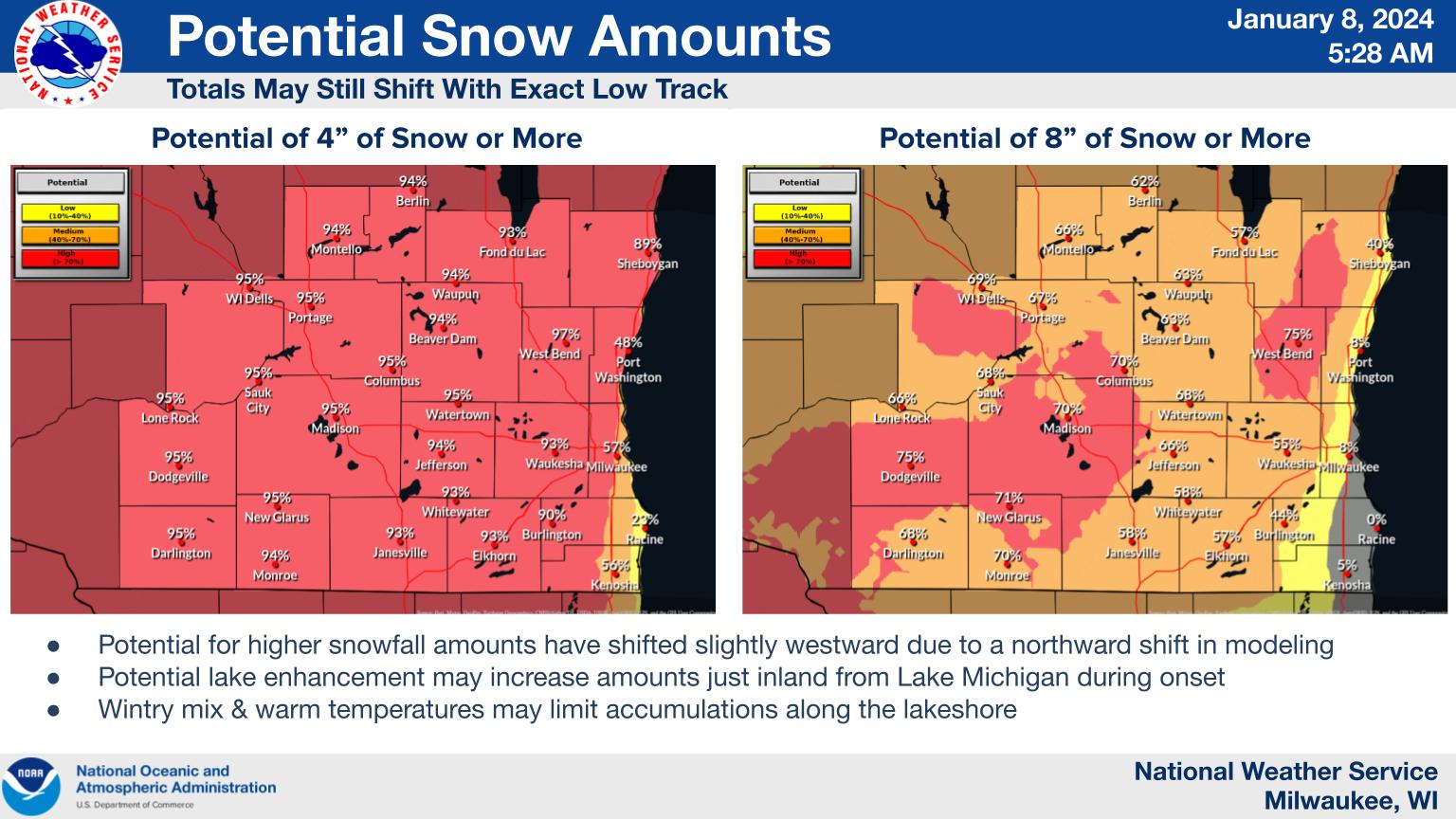
"Although the highest totals may still shift as the event approaches, high confidence (+90 percent) in 4 inches or more of snowfall exists across almost all of southern Wisconsin," the National Weather Service said.
Find out what's happening in Milwaukeefor free with the latest updates from Patch.
"Medium to high confidence (50-75 percent) in 8 inches or more exists across interior southern Wisconsin away from the warmer lakeshore regions."
Timing
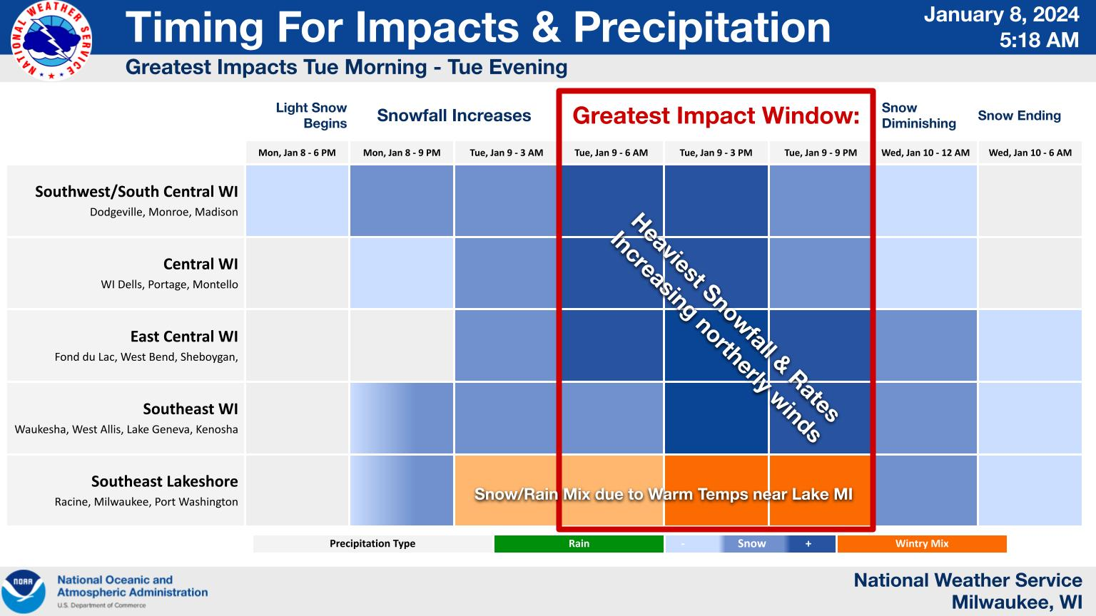
Snowfall is expected to spread from southwest to northeast Monday evening into Tuesday morning, with the heaviest snowfall expected Tuesday, the NWS notes.
Find out what's happening in Milwaukeefor free with the latest updates from Patch.
Wisconsinites should expect travel to become very difficult during the storm, especially during the morning and evening commute on Tuesday.
And guess what? More snow is expected this weekend.
Find the specific NWS forecast from the Milwaukee Airport below:
Monday: Cloudy, with a high near 35. Southeast wind 5 to 10 mph.
Monday Night: Snow, mainly after 1am. Low around 33. East wind 10 to 15 mph, with gusts as high as 25 mph. Chance of precipitation is 100%. New snow accumulation of 1 to 2 inches possible.
Tuesday: Rain and snow, becoming all snow after 2pm. High near 36. Breezy, with an east wind 15 to 20 mph becoming northeast in the afternoon. Winds could gust as high as 30 mph. Chance of precipitation is 100%. New snow accumulation of 1 to 3 inches possible.
Tuesday Night: Snow, possibly mixed with rain before 1am, then a chance of snow. Low around 28. Blustery, with a north wind 15 to 20 mph becoming northwest after midnight. Winds could gust as high as 35 mph. Chance of precipitation is 100%. New snow accumulation of around an inch possible.
Wednesday: A 50 percent chance of snow before 7am. Mostly cloudy, with a high near 33. Breezy, with a west wind 10 to 20 mph, with gusts as high as 30 mph.
Wednesday Night: Snow likely, mainly after 1am. Mostly cloudy, with a low around 21. Southwest wind 10 to 15 mph. Chance of precipitation is 60%. New snow accumulation of less than one inch possible.
Thursday: Snow likely, mainly before 7am. Partly sunny, with a high near 30. West wind 10 to 15 mph. Chance of precipitation is 60%.
Thursday Night: A 30 percent chance of snow, mainly after 1am. Mostly cloudy, with a low around 17. West wind 10 to 15 mph becoming northeast after midnight.
Friday: Snow likely, mainly after 1pm. Mostly cloudy, with a high near 31. Blustery. Chance of precipitation is 70%.
Friday Night: Snow likely. Cloudy, with a low around 18. Windy. Chance of precipitation is 70%.
Saturday: Snow likely. Mostly cloudy, with a high near 25. Blustery. Chance of precipitation is 70%.
Saturday Night: A 50 percent chance of snow. Mostly cloudy, with a low around 7. Breezy.
Sunday: A 40 percent chance of snow. Mostly cloudy, with a high near 15. Breezy.
Get more local news delivered straight to your inbox. Sign up for free Patch newsletters and alerts.