Weather
MD Weekend Weather Forecast: Soggy With Flood Watches
The last thing we need in Maryland is more rain, but the weekend weather forecast looks soggy, especially at the Eastern Shore.

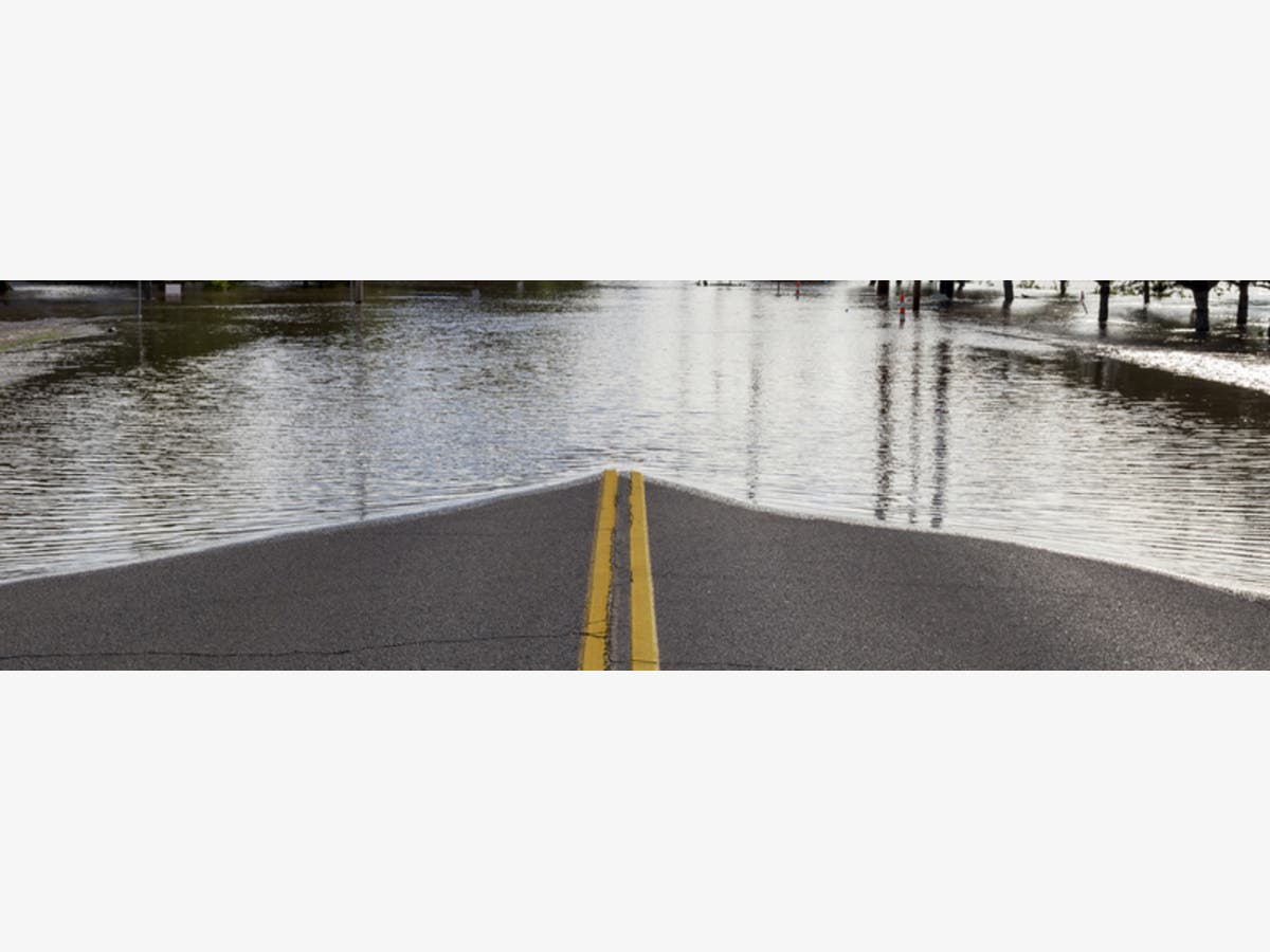
BALTIMORE, MD — Enough already: Frederick is under a state of emergency after 6 inches of rain swamped the area, Prince George's County residents had to escape their flooded car, and parts of Anne Arundel County have roads closed by water. Maryland definitely needs a dry weekend, but we're not going to get it; instead several inches more rain is possible by Saturday, and the forecast calls for rain every day through Wednesday.
After an inch of rain fell and more heavy thunderstorms were predicted through Saturday morning, the National Weather Service has issued a flood warning for small streams in parts of Anne Arundel County until 1 p.m. Friday. A separate flood warning has been issued until 5:30 p.m. Friday for much of Maryland's Eastern Shore, especially in Salisbury and Ocean City. The weather service says 3 to 5 inches of rain has fallen there since early Friday. Another 1 to 3 inches of rain is possible later this afternoon and this evening. Locations likely to see flooding include Salisbury, Cambridge, Ocean City, University of Maryland Eastern Shore, Salisbury University, and Berlin.
The rest of the Baltimore-Washington, D.C., region is under a flood watch until 8 a.m. Saturday. Periods of rain will continue across the region through at least Friday night. This rain will be heavy at times, with overall additional rainfall of 3 to 5 inches across southern Maryland and the Virginia Piedmont, and 1 to 3 inches elsewhere. While flash flooding cannot be ruled out, the primary concern is flooding of small streams and low-lying areas, says the National Weather Service.
Find out what's happening in Dundalkfor free with the latest updates from Patch.
Meanwhile, the Washington Post's Capital Weather Gang confirmed that more rain Friday would lead to an increased flooding risk for the region. "Assume any break you may experience in the fairly constant drizzle, rain and showers is a lucky one," the Post writes.
(For more news like this, find your local Patch here. If you have an iPhone, click here to get the free Patch iPhone app; download the free Patch Android app here. And like Patch on Facebook!)
Find out what's happening in Dundalkfor free with the latest updates from Patch.
Things don't improve much on Saturday, with more showers and even some thunderstorms possible for most of the day. However, the weather may dry out a little toward sunset, albeit not a whole lot. It won't be until Sunday when we finally get a break in the showers and get some sunny skies.
Friday's forecast from the weather service has a 100 percent chance for showers, with thunderstorms also possible after 2 p.m. Some of the storms could produce heavy rainfall. High near 66. New rainfall amounts between a half and three quarters of an inch possible. On Friday night, there is a 90 percent chance of showers and possibly a thunderstorm. Low around 59. New precipitation amounts between a half and three quarters of an inch possible.
Maryland officials urged residents to prepare for more rounds of storms and flooding.

Drivers should turn around if they come upon flooded roads; most flood deaths occur in vehicles. A flood warning means that flooding is imminent or occurring and residents should take necessary precautions immediately.
Here's the weekend forecast:
Friday: Showers, with thunderstorms also possible after 2pm. Some of the storms could produce heavy rainfall. High near 66. East wind 11 to 14 mph, with gusts as high as 25 mph. Chance of precipitation is 100%. New rainfall amounts between a half and three quarters of an inch possible.
Friday Night: Showers and possibly a thunderstorm. Low around 59. East wind 10 to 16 mph, with gusts as high as 24 mph. Chance of precipitation is 90%. New precipitation amounts between a half and three quarters of an inch possible.
Saturday: Showers, with thunderstorms also possible after 2pm. High near 74. South wind around 9 mph. Chance of precipitation is 90%. New rainfall amounts between a quarter and half of an inch possible.
Saturday Night: A chance of showers and thunderstorms. Mostly cloudy, with a low around 69. South wind around 11 mph. Chance of precipitation is 40%.
Sunday: A chance of showers, with thunderstorms also possible after 2pm. Partly sunny, with a high near 83. Southwest wind around 11 mph. Chance of precipitation is 50%.
Sunday Night: A chance of showers and thunderstorms before 8pm, then a slight chance of showers. Partly cloudy, with a low around 68. Chance of precipitation is 30%.
MEMA On How To Prepare
- Get your emergency kit in order. Plan for at least three days of supplies. Recommended items to include are bottled water, non-perishable food, battery-operated radio, flashlight, extra batteries, toiletries, first aid kit, pet food, prescription medications and copies of important documents (i.e., insurance policies, bank accounts, identification).
- Have a communication plan. Your family may not be together when flooding strikes, so plan on how you will contact one another. Locally, stay in touch with friends, relatives and neighbors. Designate someone out of town, not in the impacted area, to be a backup point of contact.
- See if you are in a flood-prone area. Take any necessary steps if so to get flood-ready.
![]()

(For more news like this, find your local Patch here. If you have an iPhone, click here to get the free Patch iPhone app; download the free Patch Android app here.)
Important Maryland Utility Numbers Include:
- PEPCO: 1-877-737-2662
- Baltimore Gas and Electric (BG&E): 1-877-778-2222 or 1-800-685-0123
- First Energy/Potomac Edison: 1-888-544-4877
- SMECO: 1-877-747-6326 or 1-888-440-3311
- Washington Gas: 1-800-752-7520
- Washington Suburban Sanitary Commission: 1-800-828-4002
Maryland Patch Photo Contest: Submit Your Best Pics
Tips For Drivers
The Maryland Department of Transportation's State Highway Administration reminds drivers to check www.md511.org for travel alerts and conditions, follow the agency on Twitter, or "like" its Facebook page.
If your route includes toll bridges, check out wind warnings and restrictions criteria on the authority's website. To check if wind restrictions are in place at the Chesapeake Bay Bridge check online or call 1-877 BAYSPAN.
How To Prepare Home, Family For Storm
- Get your emergency kit in order. Plan for at least three days of supplies. Recommended items to include are bottled water, non-perishable food, battery-operated radio, flashlight, extra batteries, toiletries, first aid kit, pet food, prescription medications and copies of important documents (i.e., insurance policies, bank accounts, identification).
- See if you are in a flood-prone area. Take any necessary steps if so to get flood-ready.
- Turn the refrigerator and freezer to the coldest setting in anticipation of a power outage. Open the door only when necessary and close quickly. Frozen food in a half-full freezer should remain safe for up to 24 hours, and in a full freezer, up to 48 hours.
- During a power outage use flashlights and battery-powered lanterns for light. Avoid using candles which pose a fire risk.
- Ensure a supply of water for sanitary purposes such as personal cleaning and flushing toilets. Fill a bathtub or other large container with the water. This is particularly important for those whose water runs off of an electrical system.
- If your residence could flood, store valuable and personal papers in a waterproof container.
- Stay indoors and limit travel only to absolutely necessary trips. Allow emergency crews to clear roads and provide emergency assistance.
- Use care around downed power lines. Assume a downed wire is a live wire.
- Watch out for overhead hazards such as broken tree limbs, wires and other debris.
- Make sure backup generators are well ventilated. Never use grills, generators or camping stoves indoors.
Image via Shutterstock
Get more local news delivered straight to your inbox. Sign up for free Patch newsletters and alerts.


