Weather
Severe Storms Possible Tuesday Night In Birmingham Area
The National Weather Service in Birmingham said to expect some heavy rain and possible severe storms Tuesday night.

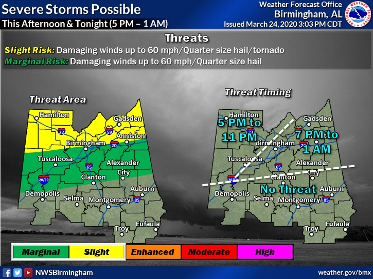
BIRMINGHAM, AL — Heavy rain headed through Alabama Tuesday night could produce some severe storms, according to a report by the National Weather Service in Birmingham. The storms are expected to travel through the area sometime between 5 p.m. and 1 a.m.
The NWS has defined an enhanced risk of severe thunderstorms for far areas in north Alabama like Muscle Shoals, Athens, Decatur, Huntsville and Scottsboro. A slight risk has been placed on areas down to Reform, Birmingham and Jacksonville, and a marginal risk as far south as Demopolis, Dadeville and Lafayette.
"The highest tornado threat will come early tonight over the Tennessee Valley in the enhanced-risk area, although we can’t rule out an isolated tornado in the slight-risk zone as well," said meteorologist James Spann. "Heavier storms will also be capable of producing hail and strong straight-line winds."
Find out what's happening in Birminghamfor free with the latest updates from Patch.
Spann added, "Be sure you have a good way of hearing warnings if they are needed. If you typically go to a community shelter, check with the county Emergency Management Agency to be sure it will be open. We are living in different times and you might need to adjust your normal severe weather plan when it comes to sheltering. But remember, you must protect yourself from a tornado first if you are in a polygon, then do the best you can when it comes to social distancing."
Get more local news delivered straight to your inbox. Sign up for free Patch newsletters and alerts.