Weather
Odds Increase For Tropical Depression In Atlantic: See AL Forecast
Forecasters are watching three areas in the Atlantic for tropical development. One could strengthen into a tropical depression, experts say.


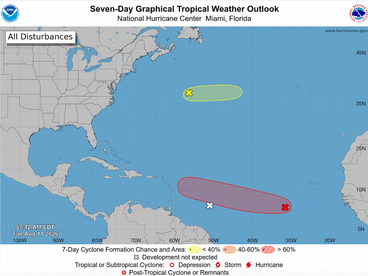
Forecasters are watching three systems in the Atlantic, including one that now has increased odds of strengthening into a tropical depression within the week.
An area of low pressure about 500 miles southwest of the Cabo Verde Islands as of Tuesday morning has a 70 percent chance of developing over the next seven days and a 30 percent chance of formation in the next two days, according to the National Hurricane Center.
If it develops, it could become Cristobal, the third named storm of the 2026 Atlantic hurricane season.
Find out what's happening in Tuscaloosafor free with the latest updates from Patch.
While this area is currently associated with limited showers and thunderstorms, “environmental conditions are forecast to become more conducive for development during the next couple of days, and a tropical depression will likely form during the latter half of this week,” the NHC said.
The system is expected to strengthen as it moves west to west-northwest across the central tropical Atlantic.
Find out what's happening in Tuscaloosafor free with the latest updates from Patch.
While it’s still too early to tell the system’s exact impact on the Gulf Coast, including Alabama, Fox 35 meteorologist Noah Bergren said in a video update posted to social media that the system “should stay north of Puerto Rico.”
He added, “But we’re probably going to see Cristobal,” likely sometime early next week.
By Tuesday or Wednesday, the system could be “a minimal hurricane” that could come close to Bermuda, Bergren said.
James Spann with the Alabama Weather Network noted two potential outcomes for the system.
"If this one develops global models show two possible scenarios... one is dissipation near the Leeward Islands due to very dry and and strong winds aloft. The other is a possible turn to the north over the open Atlantic," he wrote in a social media post.
Though forecasters had been watching another system west of what could become Cristobal, a tropical wave producing disorganized showers and thunderstorms about 600 miles east of the Windward Islands, the NHC said this area has no chance of strengthening over the next week.
The system will likely hit a large area of dry air as it approaches the Windward Islands, hindering development, forecasters said.
Experts are also watching a third area, a trough of low pressure producing showers and thunderstorms several hundred miles northeast of Bermuda.
This area has just a 10 percent chance of strengthening over the next week, the NHC said. Some development of this system is possible during the next day or so while it moves
eastward at around 20 mph across the central subtropical Atlantic. The system is forecast to reach cooler waters later this week, ending its chances of formation by Thursday.
“They’re not going to do anything. They’re not a concern,” Bergren said, adding that wind shear and cooler waters will likely “kill them both off.”
See Also:
Get more local news delivered straight to your inbox. Sign up for free Patch newsletters and alerts.