Weather
Storms Pause As California Braces For More Rain, Wind, Flooding
Two people are dead following a massive storm that knocked out power to thousands. More rain and flooding are on the way, forecasters say.

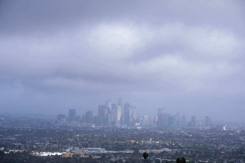
CALIFORNIA — Parts of California will see a brief reprieve Friday from a massive storm that knocked out power to thousands, caused flooding and mudslides, and contributed to the deaths of at least two people earlier this week.
The respite, however, will be short-lived.
Forecasters in California are already predicting more dangerous weather to come as a series of storm systems line up, threatening the state this weekend and into next week. Storms are likely to bring more rain and damaging winds and threaten already-saturated parts of the state with more flooding.
Find out what's happening in Across Californiafor free with the latest updates from Patch.
The Storm's Aftermath
Hurricane-force winds, surging surf and heavy rains from a powerful "atmospheric river" — or long plumes of moisture stretching far over the Pacific — pounded California on Thursday. Rocks and mudslides closed down highways and deep snow piled up at ski resorts.
The storm that came ashore Wednesday knocked out power to more than 180,000 homes and businesses, according to poweroutage.us.
Find out what's happening in Across Californiafor free with the latest updates from Patch.
By Friday, more than 59,000 remained without power. At least 18,000 were in the Bay Area.
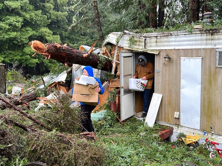
In Sonoma County, 2-year-old Aeon Tocchini was killed when a redwood tree crumpled a section of his family's mobile home where he had been sitting on a sofa, authorities said. His father and neighbors freed the boy but he couldn't be revived.
In Fairfield, a 19-year-old woman died after her vehicle hydroplaned on a flooded road and hit a utility pole, police said on Facebook.
The village of Capitola in Santa Cruz County suffered possibly the worst damage as waves that were forecast to top 25 feet crashed into homes and restaurants at the mouth of Soquel Creek and knocked out a section of its historic wooden pier.
Very high surf in Capitola, California has prompted evacuations and heavily damaged the wharf. This is what it looked like earlier as waves crashed against homes: pic.twitter.com/RVPvQ14UMR
— WeatherNation (@WeatherNation) January 5, 2023
In the coastal community of Aptos, about a dozen people were stuck at their homes because flooding, downed trees and debris blocked the road out. Violent waters tossed picnic tables against a cliff, wiped out much of the beach boardwalk, damaged its wooden wharf and left only a "skeleton" of its sea wall.
San Francisco saw localized flooding, mudslides and sinkholes earlier this week, Mary Ellen Carol, executive director of the city’s emergency management department, told CNN.
Meanwhile, the city experienced its wettest 10-day period on record for downtown since 1871, according to a Thursday tweet from the local weather service. The area recorded more than 10 inches of rain between December 26 and Wednesday, the agency said.
The Bay Area remains under a high surf advisory until 9 p.m. Friday, according to the National Weather Service.
Meanwhile, the southbound lanes of the Pacific Coast Highway are closed between Warner Avenue and Seapoint Street in Huntington Beach due to flooding, according to the city.
More Storms To Come
The atmosphere over California is in "storm mode," according to Accuweather forecasters, who predict that weather patterns through mid-January will unleash more than a foot of additional rain in some locations and yards of snow over the Sierra Nevada high country.
"Factoring in the storms that began in late December forward through mid-January, rainfall and mountain snow in some areas could rival amounts that do not occur, on average, for 25 or 50 years or more," AccuWeather Senior Meteorologist Mike Doll said.
The impacts of these storms could include new rounds of torrential rain, flooding and mudslides, as well as tremendous snow and avalanche danger over the Sierra Nevadas.
Currently, most of California will see a break Friday as the stream of moisture from the current atmospheric river ends. However, the break won't last long as another surge of moisture flows into Oregon and Northern California on Friday night.
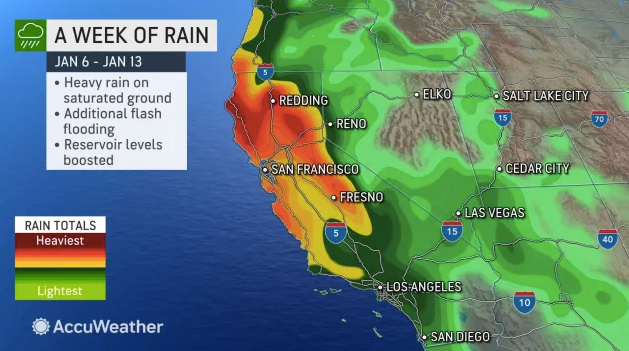
In the Bay Area, a series of weather systems are expected to impact the area through early next week, according to the National Weather Service. Rain amounts will likely be greatest in the North Bay and Coastal Ranges where totals of 2 to 4 inches are expected through Sunday.
“By Saturday night into early Sunday, the next moisture-laden Pacific cyclone is forecast to approach California with the next onslaught of heavy rain once again aiming for northern California,” the weather service said.
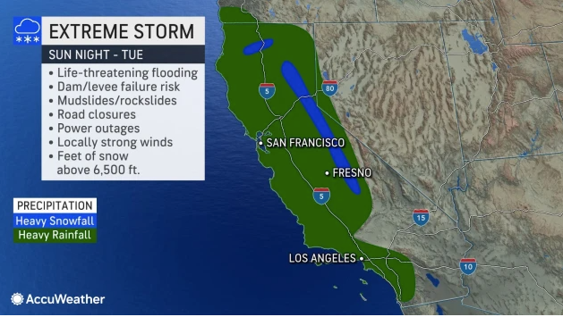
A stronger system will target the area Sunday night through Tuesday as another atmospheric river forms, according to the NWS. The system is expected to produce "copious amounts of rainfall" and will likely bring 2 to 3 inches to the Valleys and 4 to 6 inches over the higher terrain. Areas such as the Santa Cruz Mountains and Big Sur coast can expect locally higher amounts of up to 8 to 10 inches.
Flood Watches are in effect for Marin, Sonoma and Napa counties beginning Saturday morning, according to the NWS.
Parts of Southern California will likely see moisture return by Sunday, according to the National Weather Service office in Los Angeles. The strongest storm is forecast to hit the area Monday through Tuesday and will bring with it heavy rainfall, high surf and strong winds.
According to the NWS, rainfall amounts through Sunday could range between a quarter of an inch to 1 inch over San Luis Obispo and Santa Barbara counties. Farther to the south, rainfall amounts will range between trace amounts to a quarter of an inch.
Next week, rainfall totals could hit 2 to 4 inches for the coast and valleys and 4 to 10 inches in the Santa Lucias.
Will storms move out by next weekend? Not likely, forecasters told The New York Times. In fact, forecasters believe another moderate to strong atmospheric river will target the West Coast next Thursday.
The Associated Press, Bay City News Service and City News Service contributed to this report.
Get more local news delivered straight to your inbox. Sign up for free Patch newsletters and alerts.