Community Corner
Cold Storm Late Thursday Could Bring Strong Northeast Winds to the Pass
The forecast area includes the San Gorgonio Pass and the mountains of San Bernardino and Riverside counties.

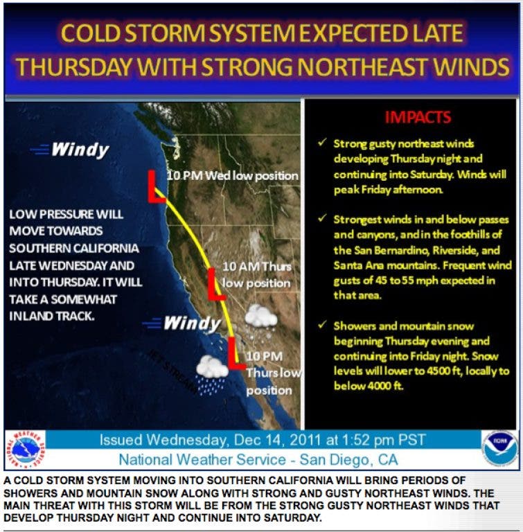

Another storm system is moving toward the San Gorgonio Pass and is expected to arrive late Thursday, according to the National Weather Service.
The cold system could bring showers and mountain snow, as well as strong, gusting northeast winds.
"The main threat with this storm will be from the strong gusty northeast winds that develop Thursday night and continue into Saturday," the Weather Service advised. "The winds are expected to peak Friday afternoon with the strongest winds in and below the passes and canyons."
Find out what's happening in Banning-Beaumontfor free with the latest updates from Patch.
The foothills of the San Bernardino, San Jacinto and Santa Ana mountains can expect frequent wind gusts in the 45 to 55 mile-per-hour range, according to the Weather Service.
Daytime temperatures for Beaumont, Banning and Cabazon are expected to remain in the 50s and 60s, with overnight lows in the high 30s to low 40s through Saturday.
Find out what's happening in Banning-Beaumontfor free with the latest updates from Patch.
The forecast area includes the San Gorgonio Pass and the mountains of San Bernardino and Riverside counties.
"Showers and mountain snow could begin Thursday evening and continue into Friday night," the Weather Service advised. "Snow levels will lower to about 4,500 feet . . . locally below 4,000 feet at times. Snow amounts of 2 to 4 inches are expected . . . mainly in the San Bernardino and Riverside mountains."
The earlier this week brought .36 of one inch of rain to Beaumont and 4 inches of snow to Pine Cove, according to the Weather Service.
Very little snow reached lower elevations in the San Gorgonio Pass during a storm system Monday and Tuesday, but were evident higher in the mountains.
Get more local news delivered straight to your inbox. Sign up for free Patch newsletters and alerts.