Weather
Heat Dome Settles Across The Pass Area: How Hot Will It Get This Week?
The Inland Empire will see many days above 100 degrees for the next week. Here's where it will be hottest.


INLAND EMPIRE, CA — Inland Empire residents, brace yourselves for another heat wave.
Triple-digit temperatures will be the norm for most of the week across the Inland Empire, where a chance of scattered thunderstorms over the mountains and deserts is also in the forecast, according to the National Weather Service.
"Temperatures will increase to around three to seven degrees above normal by Thursday, which is still forecast to be the hottest day of the week for the mountains westward," the NWS said in a statement Monday. "Heat in the low deserts will likely peak earlier in the week, as a return of monsoonal moisture on Thursday may limit heating there."
Find out what's happening in Banning-Beaumontfor free with the latest updates from Patch.
According to NWS forecast charts, ridges of the high pressure "heat dome" will strengthen over Texas, the Great Basin and Four Corners area and further influence weather patterns throughout the inland region going into the weekend.
This follows similar trends that began in July, resulting in multiple triple-digit days over the previous month in the IE.
Find out what's happening in Banning-Beaumontfor free with the latest updates from Patch.
"Continued humidity and above-normal overnight temperatures will contribute to higher heat risk," the NWS stated. "As the high becomes centered closer to the Four Corners region late in the week, south to southeasterly flow aloft will help bring in another round of monsoonal moisture. Moisture begins to increase by Thursday."
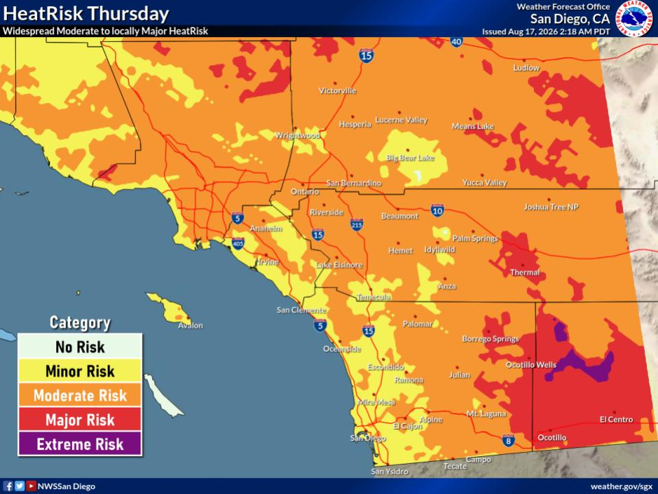
Unfortunately, according to forecast reports, the potential for widespread thunderstorms is minimal.
In the Riverside metropolitan area, daytime highs are forecast to reach the upper 90s Tuesday, with lows generally in the low 70s nightly. From Wednesday to Saturday, daily temps will likely peak at or just above 100 degrees, with no change in overnight lows.
Across the Coachella Valley, highs will top out around 110 degrees all week long, with overnight temps in the upper 80s.
Though the Lake Elsinore area is predicted to see high temperatures in the low 100s throughout the week and nightly lows around 70 degrees, the Temecula Valley will be among the coolest places in the IE, the National Weather service says. The mercury is expected to peak in the low to mid-90s from Tuesday to Saturday, with lows settling in the mid to upper 60s at night, according to meteorologists.
In the Pass Area, here's what you can expect for the next week of weather:
Tuesday
Partly sunny, with a high near 99. West wind 10 to 15 mph, with gusts as high as 20 mph.
Tuesday night
Mostly clear, with a low around 73. Southwest wind 10 to 15 mph, with gusts as high as 20 mph.
Wednesday
Sunny, with a high near 102. West wind 5 to 15 mph becoming east in the morning. Winds could gust as high as 25 mph.
Wednesday Night
Mostly clear, with a low around 75. West wind 5 to 10 mph becoming north after midnight. Winds could gust as high as 20 mph.
Thursday
Sunny, with a high near 102. North wind 5 to 15 mph becoming southwest in the morning. Winds could gust as high as 20 mph.
Thursday Night
Mostly clear, with a low around 75.
Friday
Mostly sunny, with a high near 99.
Friday Night
Mostly clear, with a low around 73.
Saturday
Sunny, with a high near 98.
Saturday Night
Mostly clear, with a low around 72.
Sunday
Sunny, with a high near 98.
Sunday Night
Mostly clear, with a low around 71.
Monday
Sunny, with a high near 97.
Get more local news delivered straight to your inbox. Sign up for free Patch newsletters and alerts.