Weather
Rain Blows In To Douse Pass Area Tuesday Night: Flood Watch In Effect
A Pass Area Flash Flood Watch will last through Wednesday as the latest storm system brings strong wind and up to 2 inches of rain.


BANNING, CA — The sunshine was fun while it lasted. This week, rain was forecast starting Tuesday night across the Inland Empire and with it comes hazardous weather conditions of strong winds and flooding in some areas, according to the National Weather Service. Banning and most Inland Empire mountain towns were placed under a flood watch until Wednesday at 2 p.m., according to the NWS.
"A trough of low pressure with an associated atmospheric river will bring widespread precipitation, along with gusty westerly winds, in the mountains and deserts, beginning Tuesday and going through Wednesday," NWS officials said in a Monday announcement. "Rain is expected to spread across the area Tuesday and Tuesday night, then decrease from the northwest Wednesday afternoon and evening."
The wet weather was predicted to douse Banning, Beaumont and the Pass Area starting Tuesday night, bringing 1.5 to 2 inches of rain. Showers are likely Wednesday in the entire county, including the deserts, according to the NWS. The heaviest rain was predicted to fall late Tuesday and early Wednesday, according to NWS Meteorologist Alexander Tardy.
Find out what's happening in Banning-Beaumontfor free with the latest updates from Patch.
This is all part of a pattern that has slammed the Inland Empire weekly for about a month, he said.
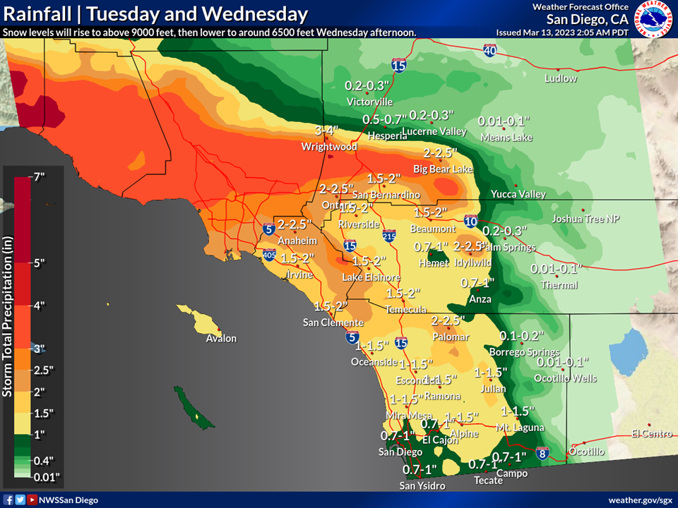
At the same time, Palm Desert and Palm Springs would see around .3 inches of rain, according to predictions from the National Weather Service.
Find out what's happening in Banning-Beaumontfor free with the latest updates from Patch.
The posted Flood Watch would likely be "caused by rain, and snowmelt is possible," the NWS reported. "Excessive runoff may result in flooding of river, creeks, streams and other low-lying flood-prone locations."
Meteorologists said precipitation in the Riverside metropolitan area will be anywhere from three-quarters of an inch to 1.5 inches over the 24-hour period.
The mountain communities of Idyllwild-Pine Cove and Mountain Center, as well as the San Gorgonio Pass, were specifically referenced in the watch.
"Snow levels will rise above 9,000 feet Tuesday afternoon, then fall to around 6,500 feet Wednesday afternoon," according to the NWS. "That would mostly limit snowfall to above 7,000 feet and mostly on Wednesday afternoon."
Daytime temperatures will be about 65 degrees in the Riverside area Tuesday, while on Wednesday, the mercury will settle around 60, with lows in the low 50s Tuesday and Wednesday nights.
In the Coachella Valley, temperatures will top out in the mid to upper 70s Tuesday and Wednesday, with lows in the low to mid 50s.
In Southwest Riverside, temps will peak in the mid 60s on Tuesday and the mid 50s on Wednesday, with lows in the mid to upper 40s, according to the NWS.
Tuesday
Rain likely, mainly after 11am. Mostly cloudy, with a high near 62. West wind 10 to 15 mph increasing to 15 to 20 mph in the afternoon. Winds could gust as high as 30 mph. Chance of precipitation is 60%. New precipitation amounts between a quarter and half of an inch possible.
Tuesday Night
Rain. The rain could be heavy at times. Low around 51. Southwest wind 15 to 20 mph, with gusts as high as 30 mph. Chance of precipitation is 90%. New precipitation amounts between three quarters and one inch possible.
Wednesday
Rain before 11am, then a chance of showers after 11am. The rain could be heavy at times. High near 54. Southwest wind 10 to 20 mph, with gusts as high as 30 mph. Chance of precipitation is 90%. New precipitation amounts between a half and three quarters of an inch possible.
Wednesday Night
Mostly cloudy, with a low around 43. Breezy, with a southwest wind 20 to 25 mph, with gusts as high as 35 mph.
Thursday
Mostly sunny, with a high near 60.
Thursday Night
Partly cloudy, with a low around 46.
Friday
Mostly sunny, with a high near 62.
Friday Night
Mostly cloudy, with a low around 47.
Saturday
Partly sunny, with a high near 61.
Saturday Night
A slight chance of rain. Mostly cloudy, with a low around 47.
Sunday
A chance of rain. Partly sunny, with a high near 58.
Sunday Night
A slight chance of rain. Mostly cloudy, with a low around 48.
Monday
A slight chance of rain. Mostly cloudy, with a high near 58.
Get more local news delivered straight to your inbox. Sign up for free Patch newsletters and alerts.