Weather
Burlingame Weather: 'Robust Warming Trend' On The Way, NWS Says
Weather forecasters say that we can expect some substantial temperature changes soon! [breaking]

BURLINGAME, CA – As you plan your week around the Bay Area, get ready for some warmer weather. After a weekend of temperatures below seasonal average – and even some rain in places – forecasters say that a "robust warming trend" is en route.
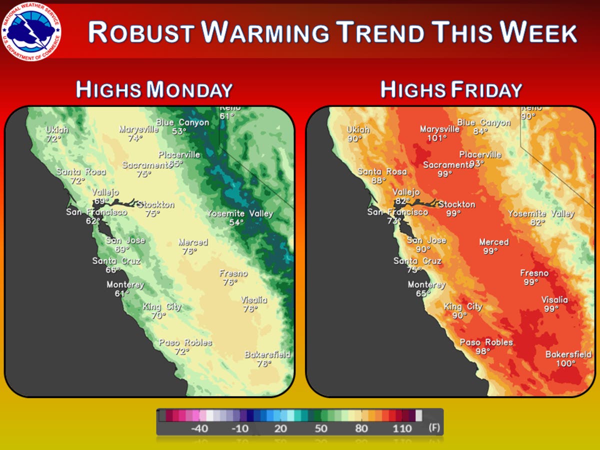
'"Locally breezy and cool conditions will persist [Monday] as an upper level trough begins to shift inland away from the coast," the National Weather Service said. "A more robust warming trend is forecast through late week with temperatures warming to above seasonal averages by Thursday."
By this weekend, you can expect dry weather conditions to continue.
Find out what's happening in Burlingame-Hillsboroughfor free with the latest updates from Patch.
Cool and locally breezy across the #BayArea to start the week. Temperatures then warm through late week to above seasonal averages! #CAwx pic.twitter.com/DmUyUryOda
— NWS Bay Area (@NWSBayArea) June 12, 2017
Here's what you can expect in Burlingame this week, according to the NWS:
Today
Partly sunny, then gradually becoming sunny, with a high near 65. Breezy, with a west northwest wind 18 to 23 mph, with gusts as high as 30 mph.
Find out what's happening in Burlingame-Hillsboroughfor free with the latest updates from Patch.
Tonight
Partly cloudy, with a low around 53. Breezy, with a west wind 15 to 24 mph, with gusts as high as 31 mph.
Tuesday
Sunny, with a high near 70. West wind 8 to 13 mph increasing to 16 to 21 mph in the morning. Winds could gust as high as 26 mph.
Tuesday Night
Mostly clear, with a low around 53. West wind 14 to 20 mph, with gusts as high as 25 mph.
Wednesday
Sunny, with a high near 72. West northwest wind 9 to 11 mph.
Wednesday Night
Mostly clear, with a low around 54.
Thursday
Mostly sunny, with a high near 76.
Thursday Night
Mostly clear, with a low around 56.
Friday
Sunny, with a high near 79.
Friday Night
Mostly clear, with a low around 56.
Get more local news delivered straight to your inbox. Sign up for free Patch newsletters and alerts.