Neighbor News
Take a Walk and Let the Hills Tell Their Story
Get out and explore. The land is stunningly beautiful and steeped in history. Learn (and feel) things you never knew you never knew!
The Martin Canyon Creek trail on the west side of Dublin is one of our best kept secrets. Located just off of Silvergate Drive and just minutes from I580, the trail follows the old creek bed and climbs a little over a mile to the very edge of the city limits. The trail is decently maintained and consists of crushed stone or packed soil at most places. It gets a little steep at times, but most anyone can do the first mile without too much of a problem. There are a couple of parallel, single track paths that branch off on the right to get a little closer to the creek. Along the way, I’ve seen deer and wild turkeys. The trail skirts the northern edge of housing developments and after a ½ mile or so gives beautiful views of a horse ranch on the hill to the right. Hawks and turkey vultures are often seen swooping overhead. This first part of the hike is really just a stroll in the park, and a beautiful one at that.
Things get a little more interesting at the city limits gate where the trail links up with the Dublin Hills Regional Park- the newest of the East Bay parks. From the gate, the next mile is all climb. Total elevation change from the very beginning is only ~500 feet, but it’ll get your heart pumping. From the gate, the scenery is entirely different. Grassy fields give way to a shaded canyon with moss covered trees. Even on the brightest and warmest of days, this part of the trail can seem cool, dark and remote. Unlike the well maintained roads at the start of Martin Canyon Creek, this second mile of the trail is very much single track in most places. It ascends literally carved into the hillside with some fairly steep slopes to your immediate right. Though not especially treacherous, I probably wouldn’t recommend this second mile for small children or for someone with a fear of heights. Believe it or not, going up is much easier than coming down, especially when the ground is extremely dry and loose, or wet. The trail meanders along the edge of the canyon and eventually (around the 2 mile mark) loops to the left and opens up into the extremely sunny and bright grassy hill tops of the Dublin Hills Regional Park and the Donlon Loop trail.
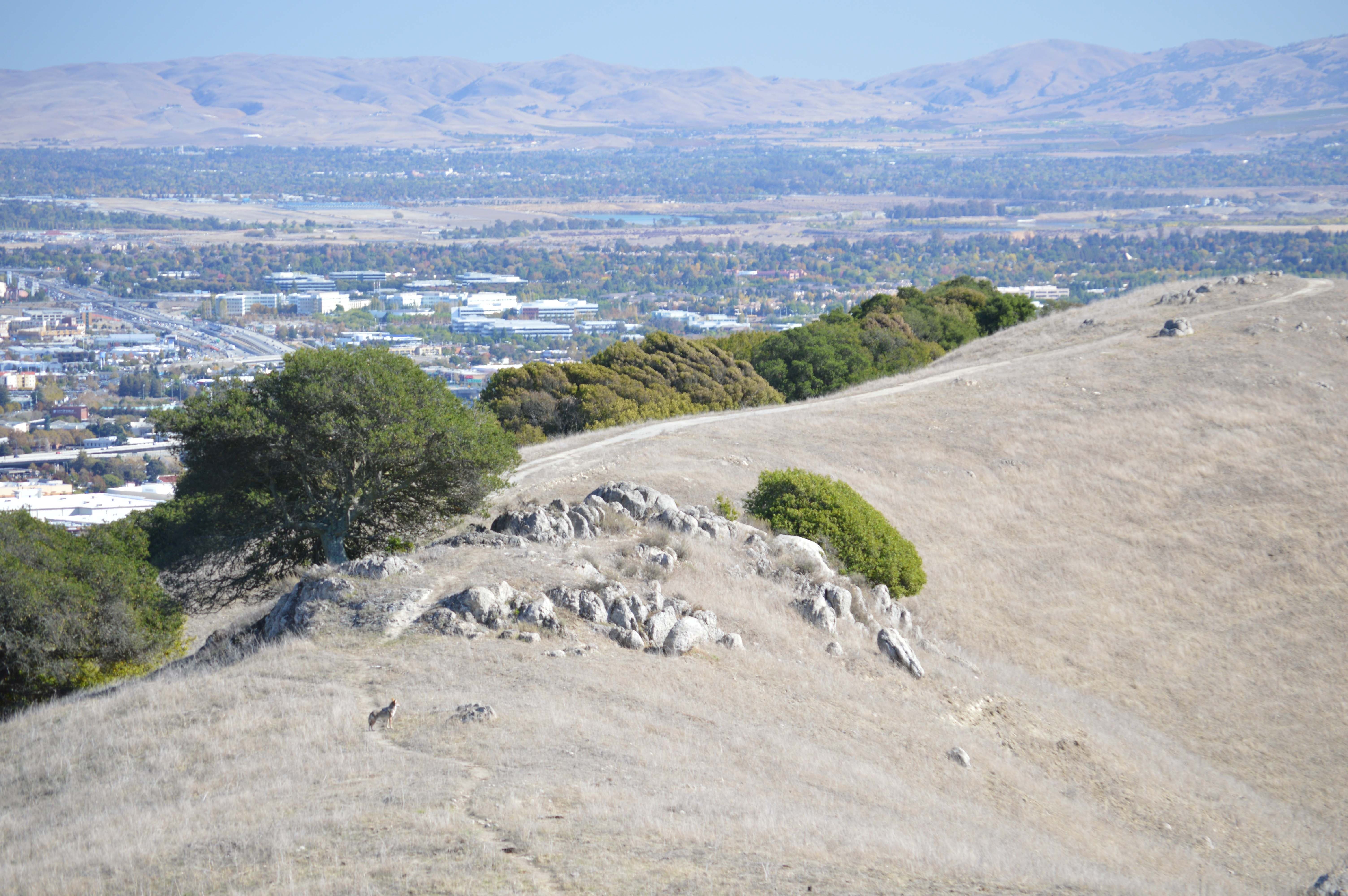
Climbing to the crest of the hill before you, you have options. To your left (east) is a rocky point overlooking the city of Dublin. To your right (west) is another rocky point that almost looks like a citadel with views all around. I recommend exploring both, but do be careful where you step or put your hands as things that crawl tend to frequent these areas. I personally skip the rocks in the warmer months and when the grass is still tall. If you venture into the rocks, you will see fossilized shells – evidence that these hilltops were once the ocean floor. There is also a ceramic gnome nestled between the rocks. If you are lucky (and there in the late afternoon), you just might spot our coyote neighbors that frequent this area. And if you are really lucky, you might witness them gathering their dinner diving head first for ground squirrels. Remember, this is their home too and part of the reason we protect these open spaces. Besides, Dublin’s hills are best when shared. Enjoy!
Find out what's happening in Dublinfor free with the latest updates from Patch.
To get home, the single track trail over the rocky citadel connects to the Donlon Loop trail. If you cross the rocky citadel and then bear left, the trail drops down to the mud pool. From the mud pool, you can take the Donlon Loop trail along the trees below Donlon Point, exit at the townhouses at Brigadoon Way and take Dublin Blvd back to the trailhead on Silvergate. Total distance either way is ~4.4 miles.
Happy trails!