Politics & Government
City of El Cerrito Releases Proposed San Pablo Avenue Specific Plan
The El Cerrito Planning Commission will review the plan at a special meeting on September 4.

The City of El Cerrito has released the Proposed San Pablo Avenue Specific Plan.
The El Cerrito Planning Commission will hold a special meeting on September 4th to consider recommending the Specific Plan to City Council. Comments may be submitted at the Planning Commission meeting in person or in writing.
The El Cerrito City Council will hold a special meeting on September 22, 2014to consider adoption of the Plan. Written comments may be submitted to the attention of Melanie Mintz, El Cerrito City Hall, 10890 San Pablo Avenue, El Cerrito, CA 94530 prior to September 12th to be included in the Council packet or comments may be submitted at the City Council meeting in person or in writing.
Find out what's happening in El Cerritofor free with the latest updates from Patch.
Both meetings will take place at El Cerrito City Hall, 10890 San Pablo Avenue, El Cerrito, CA 94530.
The Proposed San Pablo Avenue Specific Plan can be downloaded from the City’s website at www.el-cerrito.org/SPASP.
Find out what's happening in El Cerritofor free with the latest updates from Patch.
The purpose of the San Pablo Avenue Specific Plan is to articulate a vision for the future of San Pablo Avenue in El Cerrito, the City’s main commercial thoroughfare with the goal of catalyzing economic development and improving livability.
The Specific Plan’s key principles are to deepen a sense of place and community identity, attract private investment, strengthen partnerships, enhance the public realm, promote the everyday use of transit, walking, and biking, and foster environmental sustainability.
The Plan area includes the area around the two and one-half mile section of San Pablo Avenue that traverses El Cerrito. The Plan area extends east to include the Ohlone Greenway, a multi-use path beneath the elevated BART tracks. Bordered by the City of Richmond to the West, the Plan Area includes parcels within both cities and has been developed over several years through collaboration between staff from both cities and community members.
The Specific Plan establishes land use and development standards to promote investment and address future residential and commercial growth in three areas within El Cerrito: Downtown, Midtown, and Uptown. Unique characteristics and development opportunities are identified for each of these thee areas.
The Specific Plan addresses circulation along San Pablo Avenue and adjoining streets by variety of transportation options, including mass transit, automobiles, walking and biking. The Plan aims to increase the number of people walking, biking and using transit along San Pablo Avenue.
“This Plan supports the long-term General Plan goal of revitalizing San Pablo Avenue as well as the Climate Action Plan’s Sustainable Community goals by encouraging more compact, higher density development along the Avenue and increasing El Cerrito’s economic base to create more jobs, encourage greater vitality and more pedestrian-friendly economic activity,” said Melanie Mintz, the city’s Interim Community Development Director. It also supports the City’s Strategic Plan goal of deepening a sense of place and community identity by reimagining underdeveloped and underutilized properties through advance planning that encourages investment and/or new development and by encouraging the use of alternative modes of transportation.
PLAN GOALS:
The San Pablo Avenue Specific Plan’s key principles are to deepen a sense of place and community identity, attract private investment, strengthen partnerships, enhance the public realm, promote the everyday use of transit, walking, and biking, and foster environmental sustainability in El Cerrito. Five goals were developed, along with strategies to achieve those goals by 2040:
Goal A: Strengthen Sense of Place
· Strategy 1: Articulate distinctive role and identity of each focus area: Downtown, Midtown, and Uptown.
· Strategy 2: Reinforce distinguishing sense of place by responding to existing assets such as the Ohlone Greenway and key views.
· Strategy 3: Optimize place making in all developments.
· Strategy 4: Attract pedestrian activity to key nodes to foster community and identify places of interest.
Goal B: Ensure Return on Investment
· Strategy 1: Maximize TOD potential (BART and AC Transit).
· Strategy 2: Stimulate investment in vacant/underutilized sites at key focus areas.
· Strategy 3: Build on recent and planned private and public investments.
· Strategy 4: Leverage all investments to catalyze new investments.
Goal C: Encourage Practical and Market Friendly Development
· Strategy 1: Provide development clarity to encourage investment.
· Strategy 2: Incorporate flexible development codes that respond to constrained parcels,
· surrounding context and the market.
· Strategy 3: Allow ground floor residential development to provide flexibility and
expand the Specific Plan Area’s residential base.
Goal D: Enhance and Humanize Public Realm
· Strategy 1: Design streets for living instead of just driving through retreat place making principles.
· Strategy 2: Make large blocks human scale through midblock connections.
· Strategy 3: Create new gathering places to serve the needs of existing and new users.
· Strategy 4: Promote environmental sustainability.
· Strategy 5: Celebrate and strengthen the unique natural context.
Goal E: Catalyze Mode Shift
· Strategy 1: Promote infill development through increased land use intensity close to existing transit infrastructure.
· Strategy 2: Reduce parking requirements to encourage transit use and reduce reliance on the private automobile
· Strategy 3: Strengthen pedestrian and bicycle connectivity through existing and new connections that provide more alternatives to single-occupancy vehicles.
· Strategy 4: Integrate opportunities to create Complete Streets, multimodal travel ways
· that balance all users.
· Strategy 5: Improve connectivity between the Green Belt (Wildcat Canyon Trail) and the Blue Belt (Bay Trail) through pedestrian and bicycle connections
· Strategy 6: Improve walk ability through more intensive and varied development that provides additional services and locates more future residents in service-rich nodes.
· Strategy 7: Increase the supply, diversity and affordability of housing in proximity to existing or planned transportation investments.
PLANNING PROCESS
The former El Cerrito Redevelopment Agency undertook development of the Specific Plan jointly with the City of Richmond beginning in 2007 to develop a shared vision for the future of San Pablo Avenue. The Specific Plan was developed in coordination with previous and concurrent planning efforts in both El Cerrito and Richmond and incorporates City, stakeholder and community input from each stage of the planning process. The City of El Cerrito released the Draft Plan and Draft Environmental Impact Report on June 3 and received comments during the 45-day comment period mandated by California Environmental Quality Act (CEQA) mandated 45-day period. The comment period ended on July 21, 2014.
The Plan was developed with funding from the City of El Cerrito former Redevelopment Agency, Municipal Services Corporation, and the Contra Costa Transportation Authority/Measure J Sales Tax.
Several recent public and private investments have enhanced the Avenue and plan area, including Ohlone Greenway improvements, San Pablo Avenue streetscape improvements, bicycle and pedestrian infrastructure projects, a new City Hall, the restored Cerrito Theater, and new residential and commercial developments. The proposed Plan aims to continue this momentum by providing context-sensitive development regulations that support transit-oriented development along the corridor.
RESOURCES
The Proposed San Pablo Avenue Specific Plan Link: www.el-cerrito.org/SPASP
Meeting information: http://www.el-cerrito.org/
A map of the San Pablo Avenue Specific Plan area is attached (figure 10)
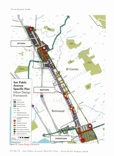
A graphic of the San Pablo Avenue Specific Plan Urban Design Framework is attached (figure 12)
Graphic and information submitted by City of El Cerrito.
Photo: A graphic of the San Pablo Avenue Specific Plan Urban Design Framework
Get more local news delivered straight to your inbox. Sign up for free Patch newsletters and alerts.