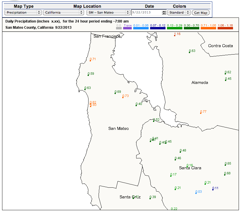


UPDATE 9/21 PM: Ummm...Well...Errr...The timing was right on, but the forecast amounts were a bit off, eh? I had measured about 1/4 inch by 10 AM, and well over 1/2 inch by the time it all ended. Reports indicate over an inch south of town and up toward Skyline! Maybe it's time to install that atmospheric river observatory mentioned in the HMB Review a couple of weeks ago...
UPDATE 9/20 AM: Well, with the front approaching, and after cutting back on the original estimates, we're back to Monday's original forecast... Somewhere between 0.10 and 0.25" over the peninsula. Watch out for those slick roads as you're buzzing around on Saturday. Ciao :-)
UPDATE 9/17 PM: Aw, man! Downgraded by an order of magnitude; Now they're saying we might just end up with some wet streets, if even that. Oh, well... There's always October. And, BTW: No change in the forecast arrival time for Autumn :-)
After another successful trip around the Sun, we again approach the first day of Autumn--this year on Sept. 22nd. And, although it's a few days out, the forecast calls for a storm system to clip the Bay Area late Friday into Saturday... Nothing serious (0.10 to 0.25"), but significant nonetheless for being the first Pacific storm to sweep through (clip?) our area. Updated images and model output at: http://www.crh.noaa.gov/outlooks/mtr