Weather
Weather Changes Return With The North Bay Hit First And Hardest: NWS
After a prolonged stretch of dry, sun-splashed days, the Bay Area's weather is turning unsettled: NWS

NORTH BAY, CA — After weeks of dry, sunny weather, rain is making a comeback across the Bay Area today—but the North Bay is expected to feel the effects first, with light rain developing earlier and lingering longer than elsewhere in the region.
According to the National Weather Service, increasing clouds this morning will give way to scattered rain chances through tonight and into early Wednesday morning, particularly in the North Bay. While rainfall totals will be modest—generally between a tenth and two-tenths of an inch where rain falls—the system marks a noticeable shift in weather, bringing cooler temperatures, gusty winds, and hazardous coastal conditions before drier weather quickly returns.
Clouds will steadily overspread the Bay Area today, with highs near 63 degrees. Winds will shift from easterly this morning to stronger southerly gusts of 12 to 17 m.p.h. by the afternoon.
Find out what's happening in Healdsburgfor free with the latest updates from Patch.
Along the North Bay coastal ranges, prefrontal drizzle or light rain is possible later this morning into the afternoon, with the bulk of the rainfall expected to arrive after sunset and move inland overnight. Rain should taper off and shift east by sunrise Wednesday.
Tonight, there is a 50 percent chance of rain, with mostly cloudy skies and lows around 50 degrees. Southerly winds of 5 to 8 m.p.h. will become light and variable after midnight, and any additional rainfall is expected to be less than a tenth of an inch.
Find out what's happening in Healdsburgfor free with the latest updates from Patch.
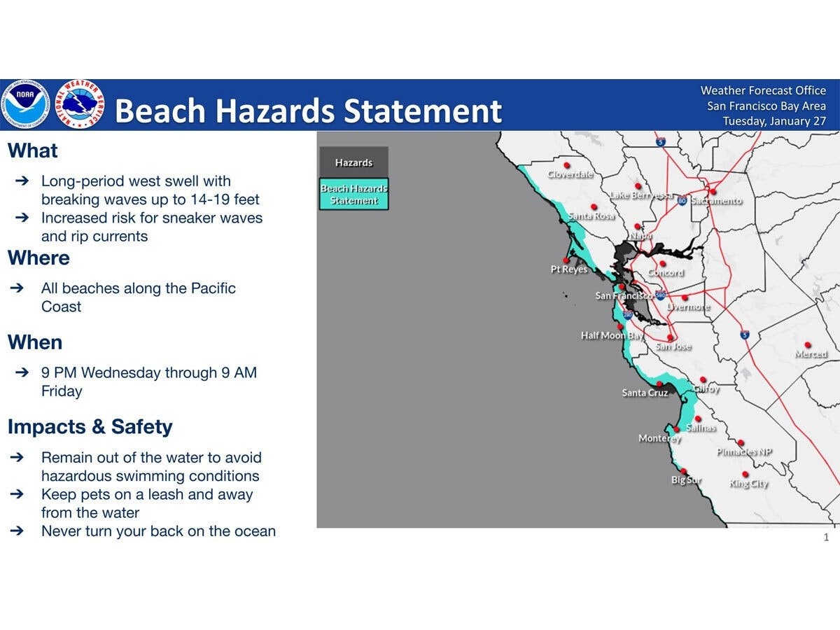
Conditions are forecast to dry out quickly by Wednesday afternoon, but coastal hazards will persist. A Beach Hazards Statement has been issued from Wednesday evening through Friday morning for the Pacific coast, warning of a long-period westerly swell that could produce strong rip currents, sneaker waves, and breaking waves reaching up to 19 feet.
Officials urge the public to stay off jetties, piers, rocks, and other waterside structures, remain out of the water during hazardous surf, and never turn their back on the ocean.
Get more local news delivered straight to your inbox. Sign up for free Patch newsletters and alerts.