Community Corner
Los Patrones Parkway Extension Part II: Estimated $50 Million Per Mile
Los Patrones Parkway Extension Part II: Estimated $50 Million Per Mile of Construction Will Burden OC Taxpayers, What's So Free About That?
Los Patrones Parkway Extension Part II: Estimated $50 Million Per Mile of Construction Will Burden OC Taxpayers, What’s So Free About That?
Although projected to break ground in 2027, finished and open by 2031, look for all Hell to break loose once those adversely impacted wake up and smell the rancid coffee: Swaths of native habitat plowed and paved over, aesthetics of the Ortega Highway viewshed (what’s visible in the corridor looking East), San Clemente surface arterials turned into parking lots and (whoopee!) air quality will plummet in the Avenida Pico/La Pata ”Bowl.”
Costs
In February of 2021 OC Public Works (OCPW) “guestimated” the final price tag at $240 million, by aerial view map legend the Los Patrones Parkway Extension (LPPE) will be about 6 miles long. As everyone knows, costs and final sticker prices soar for these capital improvement projects that haven’t even (a) finalized planning or (b) gone through enviro-review and permitting processes.
Then taxpayers can tag on the usual 25% contingency fees for contracts subsequently let out (and these become realities as well), so it shouldn’t really surprise anyone who has followed the bouncing TCA/OCPW ball that it could easily hit that $300 million, $50 million/mile tab.
Environs
Complex, physically invasive enterprises like this, that put humans first (anthropocentric) and every other creature a distant, faintly considered second, will irreparably carve up what’s left of middle San Juan Creek’s high value ecosystems.
Find out what's happening in Laguna Beachfor free with the latest updates from Patch.
They isolate species (flora and fauna), break down Environmentally Sensitive Habitat Areas (ESHA) into separate, disconnected, and often compressed islands. Many of the State and federally listed threatened and endangered species known to live in, near, forage or migrate through the proposed route will bear the brunt.
Where we should be protecting what eco-integrity is left, to ensure they aren’t haphazardly displaced, don’t all become extinct, the indigenous wildlife have adequate carrying capacity acreage, instead they've been crammed into less and less space. This is called “Habitat Fragmentation”:
Find out what's happening in Laguna Beachfor free with the latest updates from Patch.
https://en.wikipedia.org/wiki/...
Many of the more mobile, obvious coastal sage scrub species, with larger migration needs and motivations, such as coyotes, bobcats and yes, mountain lions, are pinnacle predators. They not only keep rodents and other smaller mammal specie’s populations in check but deer numbers down to levels that keep the overgrazing and denuding of flora down to viable replenishment and sustainability. Mother Nature knows what she’s doing, a delicate balancing act. She’s been quite successful at “eco-system management” for millennia.
The LPPE will affect the endangered arroyo toad, least Bell’s vireo, Southwestern willow flycatcher, and gnatcatcher to mention just a few. And readers, it might not be just the physical displacement but the light and noise 24/7/365 from vehicles on that necessary bridge across San Juan Creek that will force wildlife out and towards the Cleveland National Forest (CNF).
As I noted in Part I, OCPW will have to either plow through, carve a very deep cleft through that hill above, north of Talega, or tunnel through it. That’s where the big $$$ ticket portions will be spent. Regardless, the 6-mile swath will become a biological dead zone with the unnatural vibrations, plus the aforementioned lights and noise.
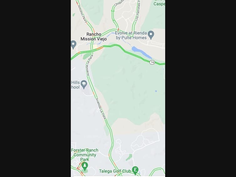
By Google Maps® (see street map photo above) it appears that the bridge will be constructed ≈2 miles upstream and east of Antonio Parkway (AP). The upstream is also critical as that stretch of San Juan Creek has been declared a critical migration corridor for the endangered, anadromous Southern Steelhead Trout.
These ephemeral creeks, that feature riparian segments with high streambed moisture content and small isolated pools in summer, usually contain a variety of salamanders, frogs and threatened species likes the Western toad.
Look at the map I downloaded: You’ll see that right where the bridge needs to transit SJC is a thickened, wide bluish area? That’s where the stream conditions are conducive to ponding, pooling, where this salmonid historically availed itself of respite on its journey either up to the forest or down the creek to the ocean.
Construction Noise
During the 4, 5 or maybe 6 years of logistical challenges and operations (believe me, it'll take longer than they promise) needed to build the LPPE, the hills will sooooo NOT be filled with the "Sound of Music." This be clamorous, heavy duty construction folks, and that's a natural amphitheater. If the physical disruption of such a ginormous, complex installation doesn't freak the critters out, that cacophony 5 days a weeks will!
Aesthetics
As for the final optics, for those of you who enjoy the State-listed Highway 74 Scenic Route corridor with the CNF as the backdrop? That bridge will be elevated, unlike AP which dips down into the channel. By my calculations and visual sighting perspective recently, hundreds of feet higher than AP will be required and of course it’ll canopy (fly) OVER the Ortega Highway then burrow into/through said hill.
It might not completely block out the entire vista during the day when completed, but dusk to dawn you’ll be looking at a superimposed concrete monster, vertical string of poles and obviously unnatural halogen lights from Cow Camp Road to the north and across the Ortega Highway to the south. During these hours the CNF will be nowhere to be seen.
As the LPPE most assuredly will need 2 wide lanes in each direction to carry those thousands of fast-moving vehicles, probably feature a center divider (also due to the high speeds), it’ll have to be at least 75-80 feet wide. If it becomes multi-use (apron bike lanes), a 100-foot width is probable.
I bring up the bikes potential because, because let’s face it: Rancho Mission Viejo (RMV) residents using Cow Camp Road could use the LPPE as a much shorter, more direct access to central San Clemente/5 Freeway down to San Onofre and even Dana Point on north to other PCH strands.
Those new E-Bikes make such commutes less imposing, and they won't need to navigate through San Juan Capistrano.
As both road bicycle exercise enthusiasts and E-Bike use and attendant lane accommodations increase, “share the road,” there’ll be a lot more distracting chaos. Intersections will become jammed gauntlets.
And btw, I can’t blame RMV corporate for allowing the easement through their property (including that hill), plus partially subsidizing the costs of planning and enviro-documentation phases. Their resident’s vehicular travels (recreational or southerly commuters), whether to the beaches or connecting to the 5 Freeway will be infinitely easier, also allowing them to circumvent central SJC.
This future dynamic will become a selling bullet point to new families: Cue up the infamous William Tell Overture Finale by Rossini “That beautiful, South OC Riviera coastal gem San Clemente? Destinations north on PCH or the maybe access the 5? Only minutes away!”
Air Quality
As I pointed out in Part I, once completed, the heavily ramped up, multi-purpose use of the “Da Bowl” corridor will snarl for long extended periods of time, probably 15 hours/day. Think of those RMV users, coupled with the thousands of LPPE vehicular commuter trips (estimated by OCPW as over 32,000/day by 2040) and hopefully dear reader, you won’t “go there.”
Air pollution concentrations from gas and diesel engine vehicles, drifting roadway dust particulates too, will peak down around SC High School and the 5 Freeway. When the 5 is backed up there (which it is, a LOT), great for outdoor athletes and regular PE classes, huh? I love the smell of hydrocarbons in the morning, howsabout you?
If presently you’ve got small children who will be going to San Clemente High School, besides playing vehicular dodgeball with those helicopter parents in Range Rovers and Escalades? Perhaps rechargeable jet packs, vertical takeoff and landing flyovers will be “the next big thing” under the Christmas tree? Parked prominently in driveway aprons as snobbish, boujee status symbols?
Joking aside, while many deride states like California for committing to all electric vehicles by 2035, if and when the LPPE opens (and no, Virginia, there's no Santa Claus and it won’t come in on budget or make the originally proposed deadline), noise and air pollution could be greatly reduced.
If you live in San Clemente and will still be there in 10 years, believe that you’ll frequently use “Da Bowl,” keep some audiobooks handy for those arterial crawls. Stare and wave at strangers, make new BFFs, you won’t be going anywhere, anytime soon anyway. If you’re driving solo, too much time on your hands, then Frankie say “Relax, don’t do it!”