Weather
Easter Storm Brings Heavy Rains, Flooding To SoCal: Latest Timeline
A storm produced by a strong cold front brought heavy rains and prompted flash flood advisories in southern California on Saturday.

LOS ANGELES, CA — A slow-moving storm is expected to drench parts of Southern California this weekend, snarling Easter travel plans with heavy rain, snow, and a chance of flash flooding.
A storm produced by a strong cold front and an atmospheric river moved into Los Angeles overnight Friday bringing bursts of heavy rain and the threat of flooding to low-lying areas.
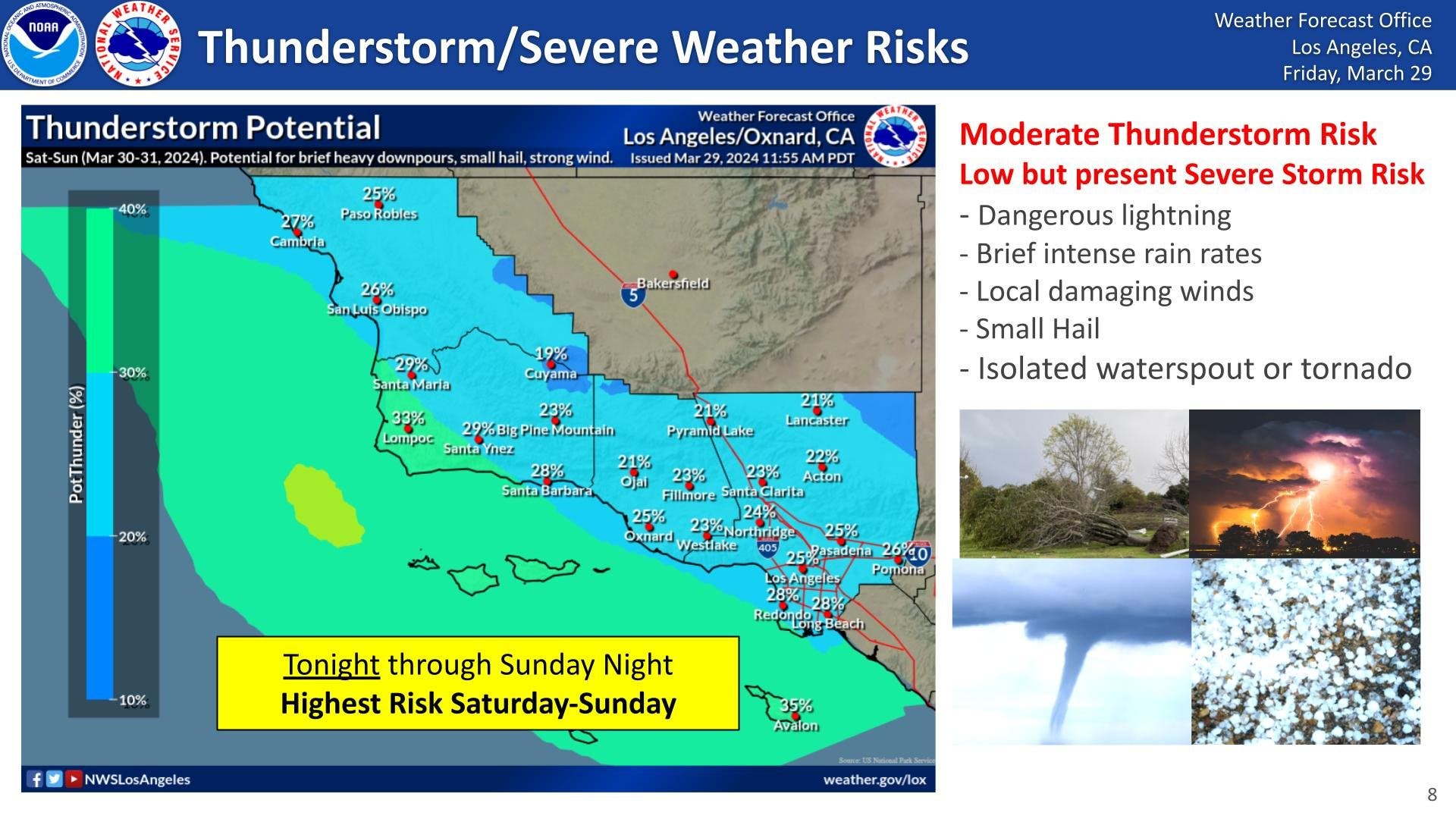
One to 2 inches of rain is expected to fall over the LA and San Diego areas through Sunday, according to the latest Accuweather forecast, while 2-4 inches is expected along the southern and western facing slopes of the Coast Ranges.
Find out what's happening in Los Angelesfor free with the latest updates from Patch.
A flood advisory is in effect until 11 a.m. for eastern Los Angeles County, according to the National Weather Service. Locations that could experience flooding include Long Beach, Acton, Pasadena, Alhambra, Whittier, West Covina, downtown Los Angeles, Glendora, Burbank and Universal City, forecasters said.
A separate flood advisory was also issued for parts of southwest California including Riverside, Orange, San Bernardino and San Diego counties until 10:45 a.m. Saturday.
Find out what's happening in Los Angelesfor free with the latest updates from Patch.
"The cold front with the heaviest rain and snow will be through the area by about 10 a.m.," NWS forecasters said Saturday morning. "Most of the area received from 1 to 3 inches of rain in the last 24 hours and will be transitioning to two days of showers and possible thunderstorms."
Gusty winds along the coast are expected to generate large waves, pounding surf, and the likelihood of overwash along the beaches, according to Accuweather. In the SoCal mountains, rain is expected to fall on major passes including Interstates 5 and 15.
By 3 p.m. Saturday, the system is expected to remain unstable as it breaks up, according to an ABC7 forecast, which could create heavy downpours at times, hail, and possible tornadic conditions.
Due to the cold front, significant snow accumulation is expected in parts of southern California above 6,000 feet. Around 3 feet of snow is likely between 6,000 and 7,500 feet with possible increasing amounts of 7,500, the NWS said.
"These winds combined with the heavy snow could produce short-term blizzard conditions. Like the rain, the most snow will fall through noon," NWS forecasters said.
A winter storm warning remains in effect through 6 p.m. Sunday for the San Bernardino County Mountains. A winter weather advisory is also in effect through 6 p.m. Sunday for the Riverside and San Diego County Mountains.
Since July 1, 2023, Los Angeles International Airport has received 19.69 inches of rain compared to a historical average of 11.25 inches, according to Accuweather. Downtown Los Angeles recorded 22.45 inches of rain since the start of July, while the San Diego area has been well above the historical average with 12.44 inches compared to 8.84 inches.
Forecasters said rain will likely end over Los Angeles County by Monday when the area is expected to see clearing skies and warmer temperatures.
Get more local news delivered straight to your inbox. Sign up for free Patch newsletters and alerts.