Weather
Mudslides, Flooding And A Busy Intersection Water Rescue Hit SoCal As 2 More Storms Barrel Down
Tuesday was the lull before the next two expected storms this week.

LOS ANGELES, CA — Southern California was walloped by a powerful winter storm Monday, marking the first of three storms set to hit the region with thunderstorms, high winds and flooding over the next week.
Monday's storm brought over two inches of rain in the wettest areas of Southern California, largely in Los Angeles County and points farther north. The storm flooded roads and brought mudslides in the mountains and burn scar areas.
Millions of residents faced flash flood warnings as rain pounded the region and people in some areas scarred by last year’s devastating wildfires were under an evacuation warning through Tuesday because of the potential for mud and debris flows.
Find out what's happening in Los Angelesfor free with the latest updates from Patch.
California’s Office of Emergency Services said it was placing fire and rescue personnel and resources in areas most at risk for flooding, mud and debris flows.
LAX issued a ground stop for departing flights Monday morning due to the heavy rain and thunderstorms. Operations were impacted at Six Flags Magic Mountain, Knott's Berry Farm and Santa Anita Park.
Find out what's happening in Los Angelesfor free with the latest updates from Patch.
🚩 TOPANGA CANYON BOULEVARD 🚩
Topanga Canyon Blvd (State Route 27) closed in both directions from PCH to Grand View Dr until further notice due to storms.
Multiple locations within the closure have mud & debris slides.👇@CaltransDist7 Maintenance & GeoTech teams on scene. pic.twitter.com/nOI3p1FsM4
— Caltrans District 7 (@CaltransDist7) February 16, 2026
In the San Bernardino Mountains, about a foot of snow fell, creating long lines of traffic amid dangerours conditions heading up and down the mountains, according to the National Weather Service.
Kashawna McInerny, a Realtor in the mountain community of Wrightwood, on Monday said she was still dealing with several tons of rock and debris on her property from Christmas and New Year's storms that pummeled the community. After the last one, she said she got help trenching part of her side yard to direct stormwater down the street and placed a barrier of metal and wood by a door in hopes of keeping out mud and debris.
“We’re not panicking yet. At least I’m not,” she said with a laugh.
Elsewhere, no evacuation orders were issued, but several roads flooded, including the busy intersection of Olympic Boulevard and Centinela Avenue, where seven vehicles were stalled and one person was rescued by firefighters, according to the Los Angeles Fire Department. Officials closed the intersection until the water cleared.
Storefronts in the Fairfax district flooded early Monday as torrential rain overwhelmed the stormwater system.
Flooding was reported elsewhere across the region, including on a segment of Colorado Boulevard in Eagle Rock that was shut down. A mudslided also impacted traffic in Pacific Palisades where evacuation warnings were issued.
Flooding was also reported on the northbound 5 Freeway in Santa Clarita, the 105 Freeway in Hawthorne and on the Baldwin Avenue on-ramp to the 210 Freeway in Arcadia.
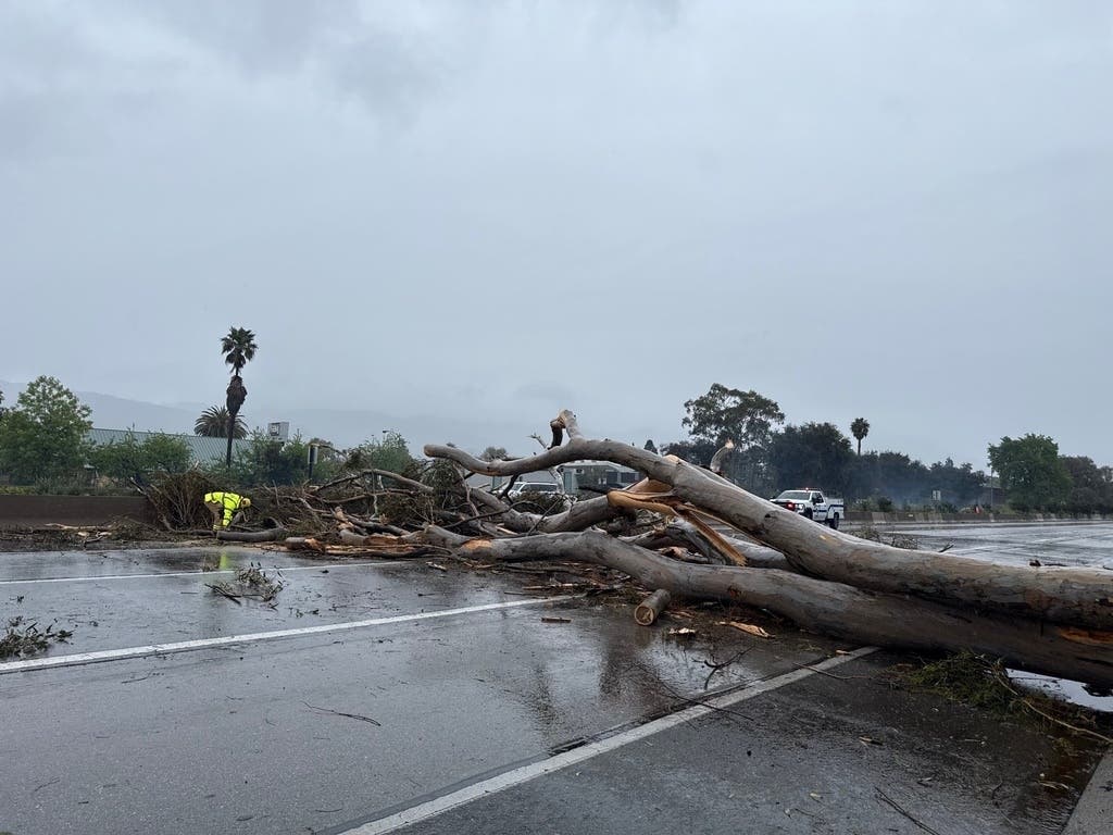
Water-logged soil may have contributed to downed trees across the area, including in Woodland Hills, where a large tree took down wires on El Canon Avenue at Valley Circle Boulevard before falling on a car early Tuesday morning.
Lull Before The (Next) Storm
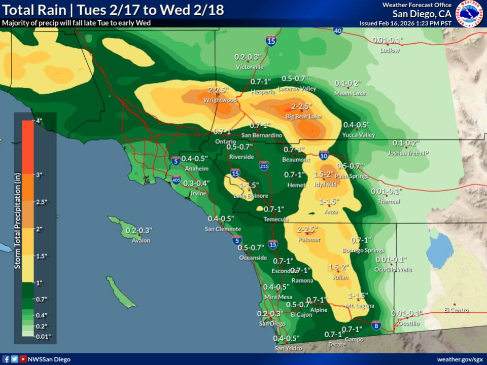
Tuesday brought a lull in storm activity across the region: More rain is expected overnight into Wednesday and again on Thursday, according to the National Weather Service.
Rain totals aren't expected to be as high as Monday's storm, with most coastal and valley locations likely to see under an inch. The snow level will drop to 3,000 feet or lower overnight. Forecasters warned that the storm could bring periods of very heavy rain and winds exceeding 60 mph.
Tuesday afternoon gusts are expected to hit 50 mph in the San Gorgonio Pass, 55 mph in the San Bernardino County mountains, and 30 mph in the Coachella Valley.
"Over the next several days, our area is expected to see several inches of rain. This increases the risk of flooded roads, downed power lines, and fast-moving water," Cal FIRE/Riverside County Fire Department said. The fire department advised residents to clear storm drains near homes, avoid driving through standing water, and to slow down and give emergency vehicles space.
Forecasters said ponding of water on roads and minor street flooding in urban areas is possible during this week's storms. In San Diego, that includes around the San Diego River through Mission Valley.
"Rain will overspread the entire area during the day on Thursday," the NWS said. "This storm is drier and less dynamic that the ones earlier this week and only a third- to a half-inch of rain is forecast."
Daytime temperatures will remain cooler for the rest of the week, lingering in the upper and mid-50s in much of Los Angeles and Orange counties and the Inland Empire. In the Coachella Valley and Palm Springs temperatures were expected to linger in the upper and mid 60s.
Overnight lows will stay in the 40s in most areas, but will drop into the 30s in the mountains and high desert from Tuesday to Friday.
City News Service and the Associated Press contributed to this report.
Get more local news delivered straight to your inbox. Sign up for free Patch newsletters and alerts.