Weather
Flood Watches Intact As Atmospheric River Sweeps Over SoCal: Forecast
Flood watches will stay in place for most around Los Angeles into early Wednesday, and the rain may ramp up overnight. Here's what to know.


LOS ANGELES, CA — A "significant" atmospheric river event is expected to dump more rain over the greater Los Angeles area into Wednesday morning before things dry out and warm up to put a cap on the workweek.
The National Weather Service's Los Angeles office said periods of moderate to heavy rain would continue to impact the forecast area overnight, with more flooding possible and locally gusty winds. Flood watches covering places like Los Angeles, Santa Barbara, Ventura and Riverside counties were extended into Wednesday.
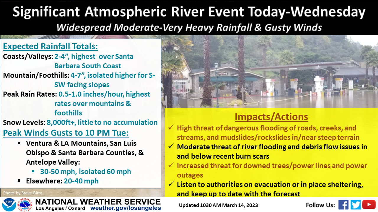
As of early Tuesday afternoon, recorded wind gusts were highest along the western San Gabriel Mountains, hitting 70 mph in places, and peaking in the 30s and 40s around the southern Salinas Valley and Santa Barbara interior.
Find out what's happening in Los Angelesfor free with the latest updates from Patch.
In an update shared just before 2 p.m., NWS Los Angeles acknowledged a somewhat slow start to the storm Tuesday for some regions but warned another burst of rain late in the afternoon and evening hours was likely to materialize.
"So far the storm has been underwhelming locals as the first impulse has moved through much faster than anticipated across SLO and Santa Barbara counties," NWS Los Angeles said Tuesday. "Rain rates around a half inch per hour have been observed but only for short durations which has significantly cut into rainfall totals there."
Find out what's happening in Los Angelesfor free with the latest updates from Patch.
By 1 p.m., San Luis Obispo and Santa Barbara counties laid claim to the highest 24-hour rainfall totals, ranging from 1.8 to 3.5 inches. The Los Angeles coast and metro saw totals closer to a quarter inch. Parts of Ventura County also got walloped Tuesday, with floodwaters triggering road closures.
@CountyofVentura Road closures due to local flooding. Visit https://t.co/w90W5iWyBt for more information. ... Cierres de carreteras debido a inundaciones locales. Visite https://t.co/w90W5iWyBt para obtener más información.#VCSheriff #CountyofVentura #VCOES pic.twitter.com/Ow2qs4bvRZ
— Ventura County Sheriff (@VENTURASHERIFF) March 14, 2023
While the atmospheric river plume still extends thousands of miles across the Pacific, forecasters said the trough was moving fast enough that it could shift and have less significant impacts. However, there is also a chance the plume could slow down or stall, which would intensify the rain.
Models were still favoring heavy rain across western San Luis Obispo and Santa Barbara counties through at least Tuesday afternoon.
Looking ahead, forecasters expect the rain to taper off into Wednesday morning, apart from a few lingering showers in eastern Los Angeles County. Drier, warmer weather is due in the wake, with highs warming to the mid-to-upper 60s for Thursday and Friday.
Another wet weather system may be in the cards for the weekend, but the National Weather Service said early models showed big discrepancies in how that will play out.
Get more local news delivered straight to your inbox. Sign up for free Patch newsletters and alerts.