Weather
Storm Expected to Go Out With One Last 'Burst'
Even as the record-setting rain eases across Los Angeles County, the region continues to face a rare combination of weather-related threats.


LOS ANGELES, CA — The atmospheric river-fueled storm that triggered more than 400 mudslides and dropped nearly a year's worth of rain in parts of Los Angeles County, is expected to cause havoc during the Wednesday evening rush hour before fading to scattered showers Thursday and Friday.
On Tuesday, various parts of the county faced a risk of flash floods, tornados, mudslides and avalanches. The mudslide and avalanche risk will continue as the storm fades out.
The final burst of downpours Wednesday evening and even the slight rain through the rest of the week remain a serious threat to canyon and hillside neighborhoods with already saturated soil.
Find out what's happening in Los Angelesfor free with the latest updates from Patch.
The rain gradually eased Tuesday and overnight into Wednesday, however, another storm will bring a "burst" of rain during the evening rush hour and into the night Wednesday, exacerbating the risk of mudslides, the National Weather Service warned. The rain could drop another inch on the Los Angeles region Wednesday.
Across Los Angeles County, scattered showers were expected to drop another inch of rain Tuesday afternoon with isolated thunderstorms causing downpours at a rate of up to an inch per hour, said National Weather Service meteorologist Carol Smith. That came on top of the more than 12 inches that fell in the Santa Monica Mountains and Sepulveda Canyon area and the nearly 14 inches that at the Cogswell Dam in the Angeles National Forest.
Find out what's happening in Los Angelesfor free with the latest updates from Patch.
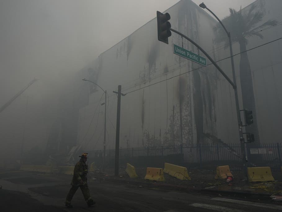
Los Angeles Fire Department Chief Kristin Crowley said that as of the LAFD had responded tomore than 307 reports of mudslides and 35 incidents of buildings requiring inspection due to mudslides or slope failures. So far, five buildings have been red-tagged as uninhabitable and seven others are yellow-tagged, which allows people to enter only to collect their belongings.
Across the state, 9 people have died in storm related crashes and flash floods, including two in Southern California, according to the governor's office.
The flooding and mudslide risk remains high.
"It's a very real risk. If you don't have to go out and drive, don't," said Smith. "When you are out driving around, be extra cautious of canyon roads. Don't drive through flood areas especially if there is a current. Up to two feet of water can carry your car away."
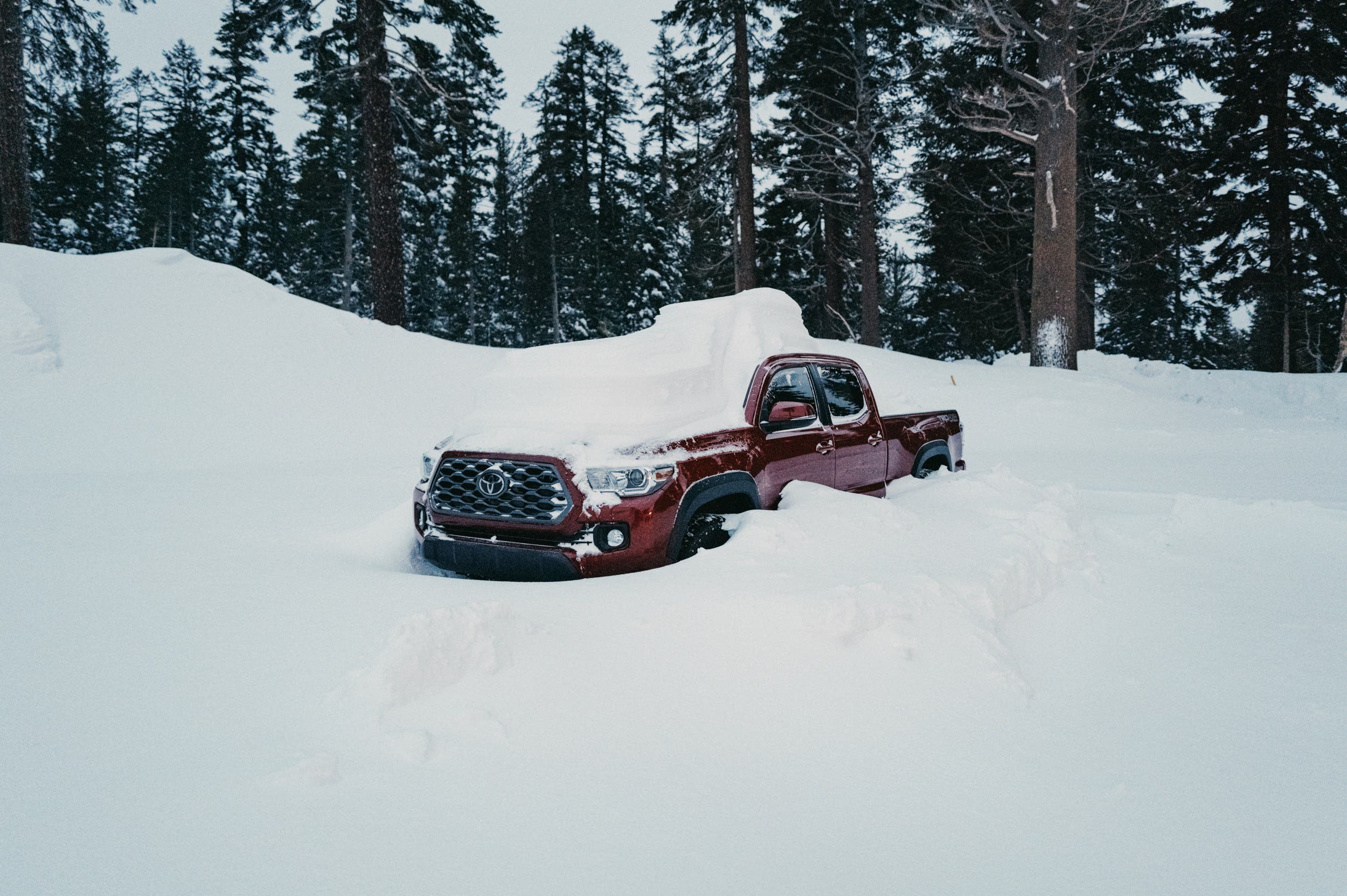
Smith also urged people to resist the urge to drive up to the snowcapped mountains, which have already received two to three feet of snow above 7,000 feet and can expect 1 to 2 feet of snow before the storm is done with Southern California.
"It's not the time to drive up and see the snow," she said.
Over the next couple of days, the mountain roads face a risk of rockslides, icy conditions and avalanches, she warned. Major mountain passes are expected to get more snow Tuesday night.
"Tonight on the Grapevine, it could get 2-4 inches of snow," Smith said Tuesday. "That's armageddon on the Grapevine."
A winter storm warning will remain in effect until 8 a.m. Thursday in the eastern San Gabriel Mountains, where forecasters said 20 inches of additional snow could fall above 7,000 feet, with as much as 3 inches possible as low as 3,000 feet.
A winter weather advisory will remain in effect until 8 a.m. Thursday in the western San Gabriel Mountains and the Antelope Valley (14) and northern Golden State (5) freeway corridors.
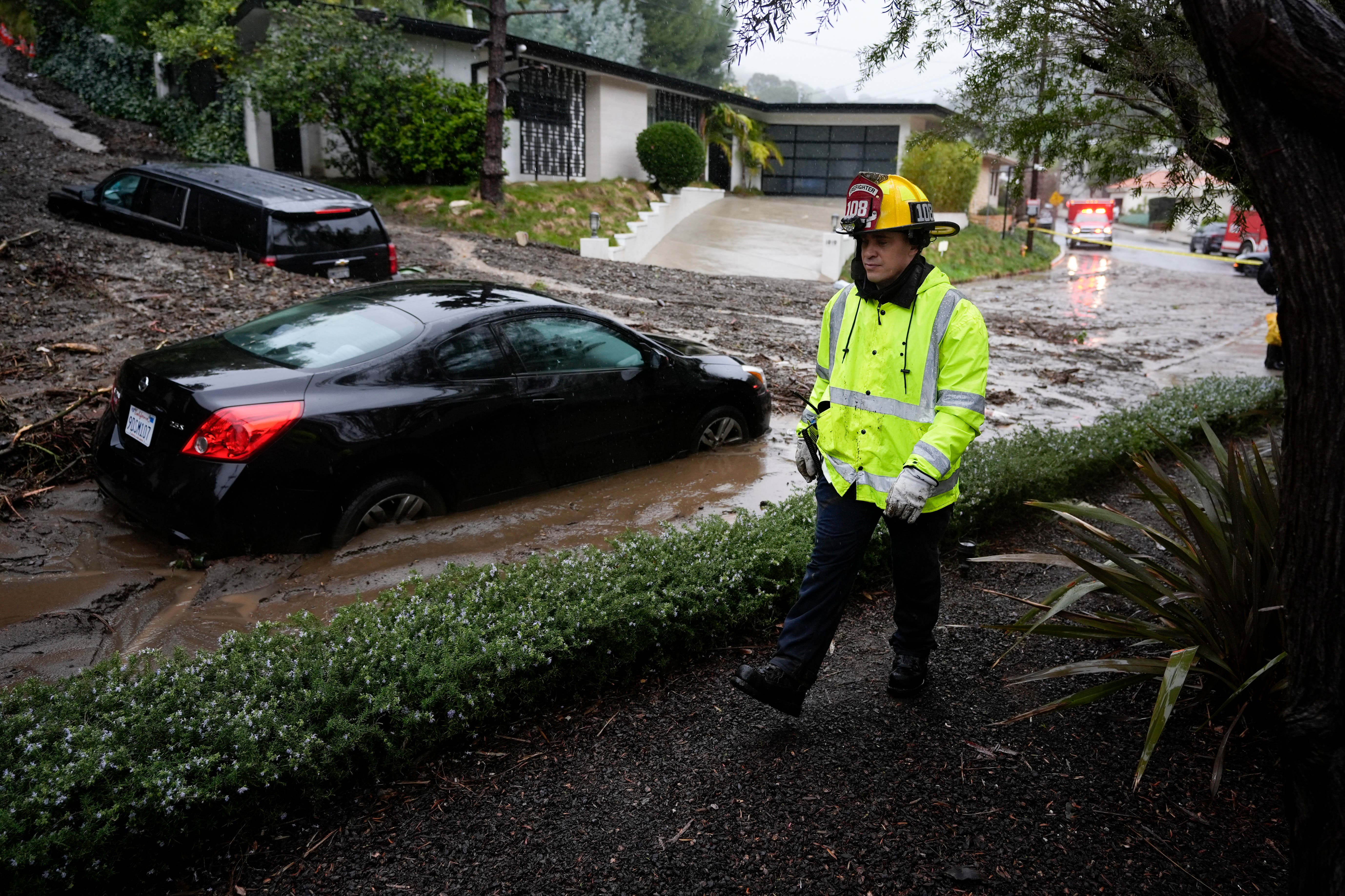
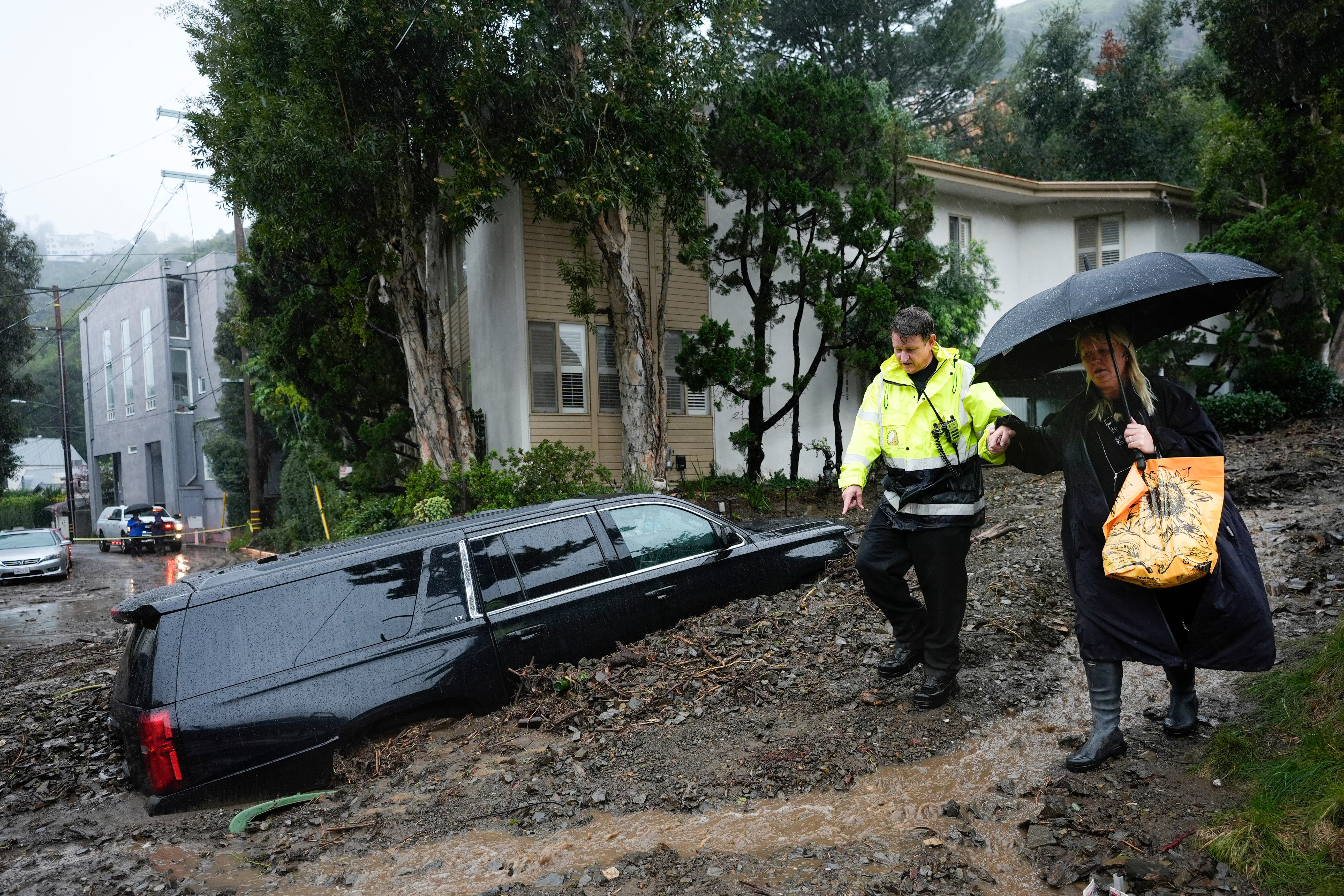
Record-setting rain totals have reached double-digits in many areas and caused mud and debris flows that forced evacuations and left some homes heavily damaged Tuesday.
The two-day rain total for downtown Los Angeles for Sunday and Monday was 7.03 inches, the third highest rain total for two consecutive days in downtown LA since 1877, when rain totals started being recorded. The highest two-day total is 7.98 inches set on Dec. 31, 1933 and Jan. 1, 1934. The second highest two-day total is 7.44 inches set on Jan. 25 and 26, 1956.
Some gusty winds are expected to develop Wednesday and continue into Thursday. There will be a chance of some precipitation by Wednesday evening, with "about a three-hour period of steady rain and mountain snow," forecasters said. Rain rates were expected to be around 0.25 to 0.5 inches per hour, highest in the mountains.
"On any other week, rain of this nature would not be much of an issue, but considering that much of our area is water logged, we might see some flooding issues in creeks and roads," according to the NWS. "There is also a 10 percent chance of thunderstorms."
"Some showers will linger around on Thursday, but all areas should finally see an end to the precipitation by Friday afternoon or evening except for light snow on the north slopes into Friday night," forecasters said.
Los Angeles County is expected to receive roughly another half-inch to 1.5 inches of rain by Friday across most of the area, with possibly double that amount in the mountains, according to the National Weather Service.
In the Hollywood Hills, a mudslide severely damaged six homes and threatened a seventh along Beverly Drive in the Beverly Crest area. Los Angeles Fire Department crews escorted 15 residents out of the area, including nine children, but no injuries were reported. City Building and Safety crews were assessing the extent of damage to the homes.
Two homes sustained significant damage in Studio City when mud and debris slid down a hillside along Lockridge Road. Fire crews evacuated residents from nine homes on the stretch. In the Tarzana/Encino area, three homes were impacted by a debris flow along Boris Drive, prompting some evacuations.
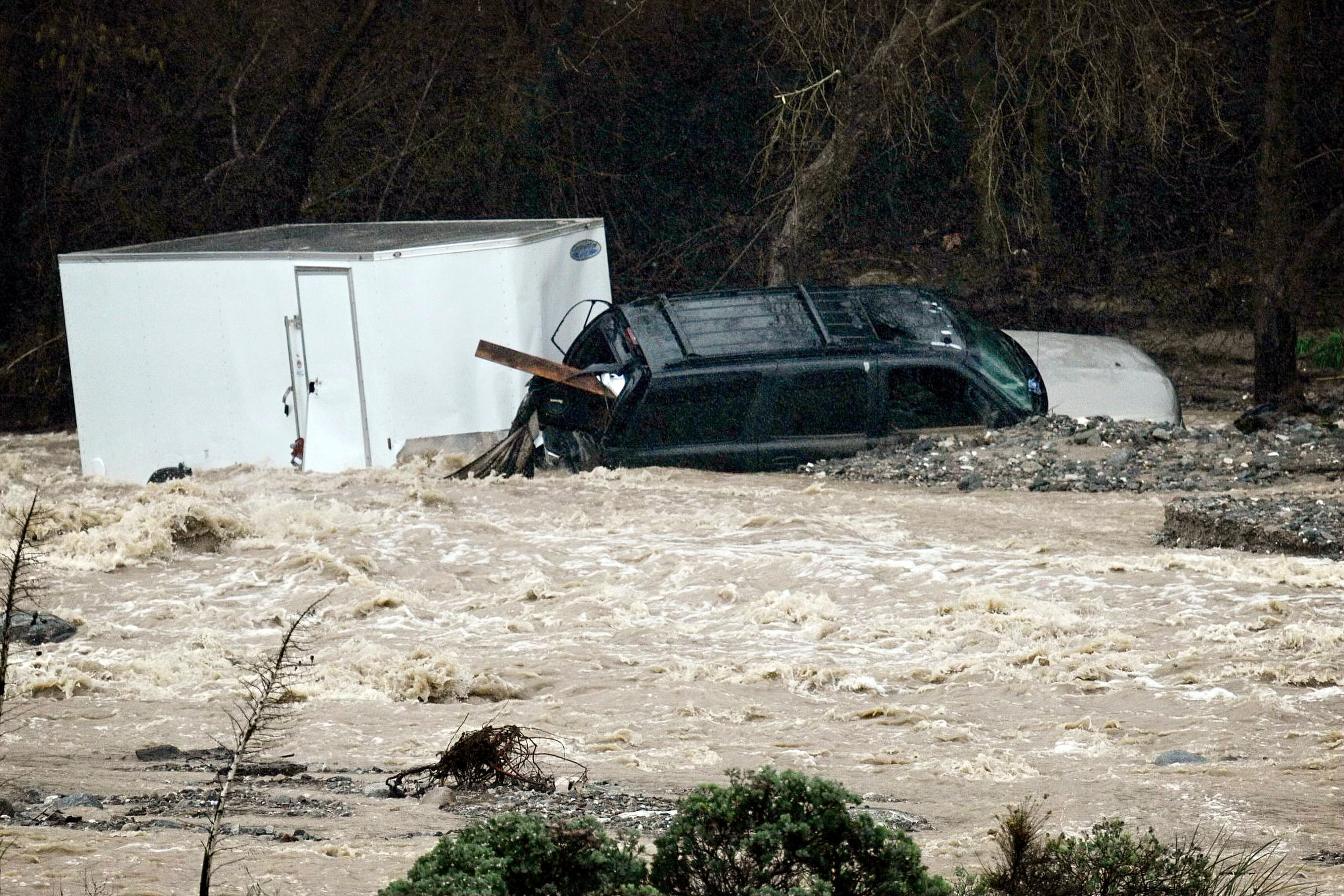
Rocks and boulders fell on parts of Malibu Canyon Road overnight, prompting a closure along that street that was later lifted. But stretches of Piuma Road and Topanga Canyon Boulevard were also closed due to flooding and debris in the Malibu/Topanga areas, with sheriff's officials reporting several vehicles completely submerged on Piuma.
The Los Angeles Fire Department reported earlier closures on Benedict Canyon and Beverly Glen Canyon roads because of flooding and rock slides.
Pacific Coast Highway at the Los Angeles County and Ventura County border was closed on the northbound side because of flooding.
Roads leading to and through the Sepulveda Basin were closed due to flooding, including Burbank Boulevard between the San Diego (405) Freeway and Balboa Boulevard and Woodley Avenue between Burbank and Victory boulevards.
Los Angeles officials urged residents to stay home and off the roads. Gov. Gavin Newsom declared a state of emergency in eight counties in the state, including Los Angeles and Orange counties.
Los Angeles County later declared its own state of emergency, and Los Angeles Mayor Karen Bass on Monday also signed a local emergency declaration.
The emergency proclamations will help expedite the procurement of vital supplies and resources, deployment of disaster service workers and the use of emergency protective measures such as evacuation orders, officials said
"We'll get any help on the way as soon as you guys request it, so just let me know," President Joe Biden told Bass in a telephone call during her late Monday afternoon briefing.
LAUSD Superintendent Alberto Carvalho said student attendance was 63% on Monday, but he said 90% of district teachers, bus drivers and classified employees reported for work.
All Malibu schools in the Santa Monica-Malibu Unified School District schools were closed Monday, with multiple reports of mud and rock flows affecting canyon roads in the area. Santa Monica campuses remained open. All schools in the district are scheduled to reopen Tuesday
Some California State University campuses were either closed or switched to modified operations Monday. Cal State Los Angeles, Cal State Northridge, Cal State Long Beach and Cal State Fullerton all adjusted operations, with many in-person classes shifting online or switching to alternative programming. Students were advised to check with their instructors for specific information.
Cal State Long Beach and Cal State Fullerton planned to return to normal operations Tuesday. Students at all campuses were again urged to check with college officials to determine the status of campus changes.
Evacuation warnings and orders were slowly lifted Tuesday as rain from the multiple-day storm slowly began to ease, but residents were still urged to remain prepared in case the threat of mudslides, flooding and debris flows returns.
Residents in the La Tuna Canyon area had been under an evacuation order since the storm began, but the order was lifted late Tuesday afternoon.
"The Los Angeles County Department of Public Works has downgraded this site to a Phase 2 from a Phase 3," according to a statement from Los Angeles city Emergency Management officials "According to the LACDPW, Phase 2 indicates that `moderate debris and mudflows are possible at more widespread locations.' Due to this downgrade, City of Los Angeles departments conducted a land survey of the evacuated area to confirm the county's assessment and concluded that the residents may return home."
The affected area was roughly bounded by Horse Haven Street to the north, Martindale Avenue to the east, Penrose Street to the south, and Ledge Avenue to the west, according to the Los Angeles Fire Department.
An evacuation center for residents that was opened at Stonehurst Recreation Center was closed Tuesday afternoon. Large animals evacuation centers at Hansen Dam Horse Park at 11127 Orcas Ave. in Lake View Terrace, and the LA Equestrian Center at 480 Riverside Drive in Burbank will remain open until 5 p.m. Wednesday.
"The La Tuna Canyon Evacuation Order has been lifted and LAPD will remove all hard closures," LAFD Fire Chief Kristin Crowley said in a statement. "As residents return to their homes, we urge them to exercise caution as the water-soaked hillsides will continue to pose a mudslide threat for days after the rain stops. We ask residents to remain vigilant and stay informed via LAFD.org and NotifyLA."
Evacuation orders that had been issued for the Agua Fire burn area along Soledad Canyon Road east of Agua Dulce Canyon Road and the Owen Fire burn area, on Santa Maria Road north of Topanga Canyon in the Topanga area, were both reduced Tuesday afternoon to evacuation warnings, although residents were still urged to be prepared to leave if needed.
Additionally, evacuation warnings were issued for areas of unincorporated Los Angeles County near burn scars, including the Juniper Hills and Valyermo areas from the Bobcat Fire, and the following areas of Lake Hughes and King Canyon from the Lake Fire:
-- 20000 block of Pine Canyon Road;
-- 18000 block of Ellstree Drive;
-- 46000 block of Kings Canyon Road;
-- 18000 block of Newvale Drive; and
-- 43000 block of Lake Hughes Road.
Duarte issued an evacuation warning for an area near the Fish Fire burn scar, but it was lifted Tuesday afternoon.
Culver City on Monday issued evacuation warnings for various streets in the Upper Crest area due to concerns about possible mud or debris flows. City officials said the warnings will be in effect until 11:59 p.m. Wednesday.
Affected areas are:
-- Cranks Road (Tellefson Road to St. James Drive) (10600 and 10700 blocks);
-- Tellefson Road (Cranks Road to Stubbs Lane) (5712 - 5825);
-- Ranch Road (Tellefson Road to Cranks Road) (10600 and 10700 blocks);
-- Stubbs Lane (entirety) (10700 block);
-- Lugo Way (entirety) (10700 block);
-- Youngworth Road (Ranch Road to Flaxton Street) (10600 block);
-- Flaxton Street (Youngworth Road to Drakewood Avenue) (10600 block);
-- Drakewood Avenue (Ranch Road to Northgate Street) (10600 block); and
-- Bernardo Road (Tellefson Road to terminus) (10800 block).
An emergency shelter was established at the Veterans Memorial Complex Multipurpose Room, 4117 Overland Ave.
In Orange County, a voluntary evacuation warning remains in effect for Silverado, Williams, Modjeska and Trabuco canyons due to heavy rains. A map with detailed depictions of the areas under evacuation warnings can be found at www.ocsheriff.gov/emergency.
Canyon residents were encouraged to prepare and voluntarily evacuate, especially those with disabilities, access and/or functional needs, and canyon residents with large animals.
Any residents with disabilities and those with access and/or functional needs requiring evacuation assistance were asked to call Orange County Sheriff's Department Dispatch at 714-647-7000.
Orange County Animal Care encouraged animal owners in voluntary evacuation areas to implement their personal evacuation plans. Pet evacuation tips are available at ocpetinfo.com/education-resources/disaster-preparedness. Any person needing assistance with information about animal or large animal evacuations should call Orange County Animal Care at 714-935-6848 from 8 a.m. to 5 p.m. or 714-259-1122 after-hours from 5 p.m. to 8 a.m.
The intense storm prompted the California Department of Water Resources to release excess storm water through the gated spillway at Pyramid Dam. The water will be stored downstream in Lake Piru for future water supply, the department reported.
The city of Los Angeles and the Los Angeles Homeless Services Authority increased shelter and housing voucher availability to accommodate an influx of homeless people coming in from the storm. Shelters were opened at the Lincoln Heights Senior Citizen Center at 2323 Workman St., Mid Valley Senior Citizen Shelter at 8825 Kester Ave. in Panorama City, South LA Sports Activity Center at 7020 S. Figueroa St. and Oakwood Recreation Center at 767 California Ave. Residents can call 2-1-1 for transportation to a shelter.
The storm was also affecting the recreational activities. Six Flags Magic Mountain, Knott's Berry Farm, the Getty Center and Villa were closed Monday as was the Los Angeles Zoo. Disneyland closed an hour earlier than scheduled, at 8 p.m.
The Los Angeles Zoo will also be closed Tuesday.
City News Service and Patch Staffer Paige Austin
Get more local news delivered straight to your inbox. Sign up for free Patch newsletters and alerts.