Weather
Tropical Storm Rachel Threatens Southern California: What To Know
It's been almost a century since a tropical storm hit SoCal, bringing a combination of tropical swells, high tides, winds and downpours.


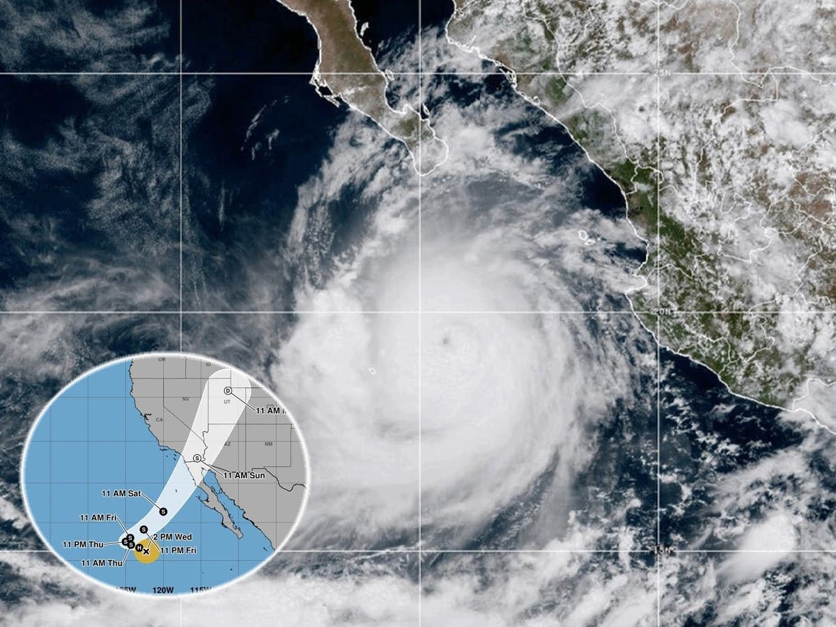
SAN DIEGO, CA — Tropical Storm Rachel is approaching Southern California, bringing the prospect of dangerous coastal flooding, powerful surf, gusty winds and torrential rain this weekend as an unusual combination of weather systems threatens to create hazardous conditions along the Southern California coastline.
Although the storm has weakened from hurricane strength, it's still expected to reach landfall as a tropical storm - not something California has seen since 1939, according to Accuweather. Hurricane Hilary came close in 2023, but "Hilary was officially downgraded to what the National Hurricane Center calls a post-tropical cyclone before the center of the storm reached the United States," AccuWeather reported. "But, heavy rain continued with the storm, fitting AccuWeather’s classification as a tropical rainstorm since that rain was associated with the tropical storm and significant impacts related to flooding persisted for days."
Currently the storm's path is unpredictable, but meteorologists expect it to reach San Diego County Sunday morning and head north into the Inland Empire with the possibility of flash flooding in Palm Springs.
Find out what's happening in Los Angelesfor free with the latest updates from Patch.
"Enough rain will occur to hinder outdoor plans and slow travel in the region. Where the heaviest rain falls, perhaps at the rate of 1-3 inches per hour, life-threatening flash flooding could occur," AccuWeather warns.
"The exact numbers we're still trying to shake that out right now, but you can guarantee that there will be minor coastal flooding because even without the impacts from Tropical Storm Rachel, we were already expecting minor coastal flooding due to just high tides, sort of being high tides in combination with an already susceptible coastline," said Kyle Wheeler, Meteorologist, National Weather Service San Diego.
Find out what's happening in Los Angelesfor free with the latest updates from Patch.
"So chances are we'll actually have more moderate or high impacts than we were expecting previously."
The storm is not expected to strike Los Angeles directly, but meteorologists say its arrival could coincide with exceptionally high tides, swells from the Southern Hemisphere and an approaching upper-level weather system, creating a potentially dangerous convergence of conditions.
"It's very unique," Bryan Lewis, a meteorologist with the National Weather Service's Los Angeles/Oxnard office, told Patch on Thursday. "It's a lot of different factors coming into play."
In the hardest-hit areas, meteorologists expect between 0.5 inches to 1.5 inches or 0.5 to 3 inches of rain, posing flooding and mudslide threats in areas such as the Line Fire burnscar San Bernardino Mountains. However, the storm's path could still shift north.
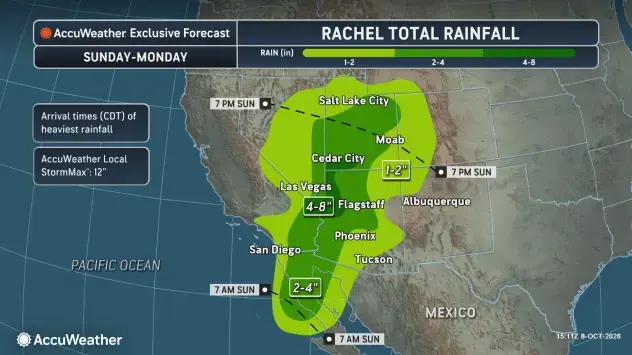
"If Rachel were to trend further north, then we could see a jump in the rainfall amounts. It's hard to say exactly what that would be, but that is sort of worst-case scenario and as of right now, we're going with the more likely scenario, which is that it stays south."
According to the National Hurricane Center's early Thursday advisory, Rachel had maximum sustained winds of 70 mph at 2 a.m. PDT, when it was approximately 895 miles west of the southern tip of Baja California. The storm was moving west-northwest at 8 mph, with a turn toward the northeast expected as it approaches the region.
What To Know About Tropical Storm Rachel
Why Coastal Flooding Is The Biggest Concern
While rainfall from Rachel is currently expected to be mostly light to moderate across the coast and heavier in the deserts and mountains, the combination of conditions developing offshore could present a more serious threat.
Lewis explained that exceptionally high tides are expected to coincide with long-period swells arriving from the Southern Hemisphere and additional waves generated by Rachel. At the same time, an unusually cold upper-level trough moving down the California coast could produce gusty winds and another significant swell from the west.
The result could be seawater pushing farther inland than usual, flooding normally dry stretches of beach and reaching vulnerable parking lots, walkways and other low-lying coastal locations.
"I haven't been here for too long, I'm still relatively new, but just in my short couple of years, I've never something this complex that I can remember," Lewis said.
The National Weather Service has issued a coastal flood advisory through 2 p.m. Tuesday for Southern California.
The advisory warns of minor to locally moderate coastal flooding, with seawater likely to inundate some vulnerable low-lying locations around high tide. Moderate to significant beach erosion is also possible, along with isolated damage in particularly exposed areas.
The greatest flooding risk is expected Sunday, especially during the morning high tide. Dangerous rip currents and elevated surf could also threaten swimmers, surfers and anyone venturing onto exposed rocks or jetties.
Where Rachel Is Headed And How Much Rain To Expect
Rachel's projected path remains subject to change, although forecasters have become increasingly confident that the center of the storm will remain south of Los Angeles County.
Lewis said the system could stay near Baja California without reaching San Diego, although another possibility would bring it closer to the San Diego area before moving northeast into the western United States.
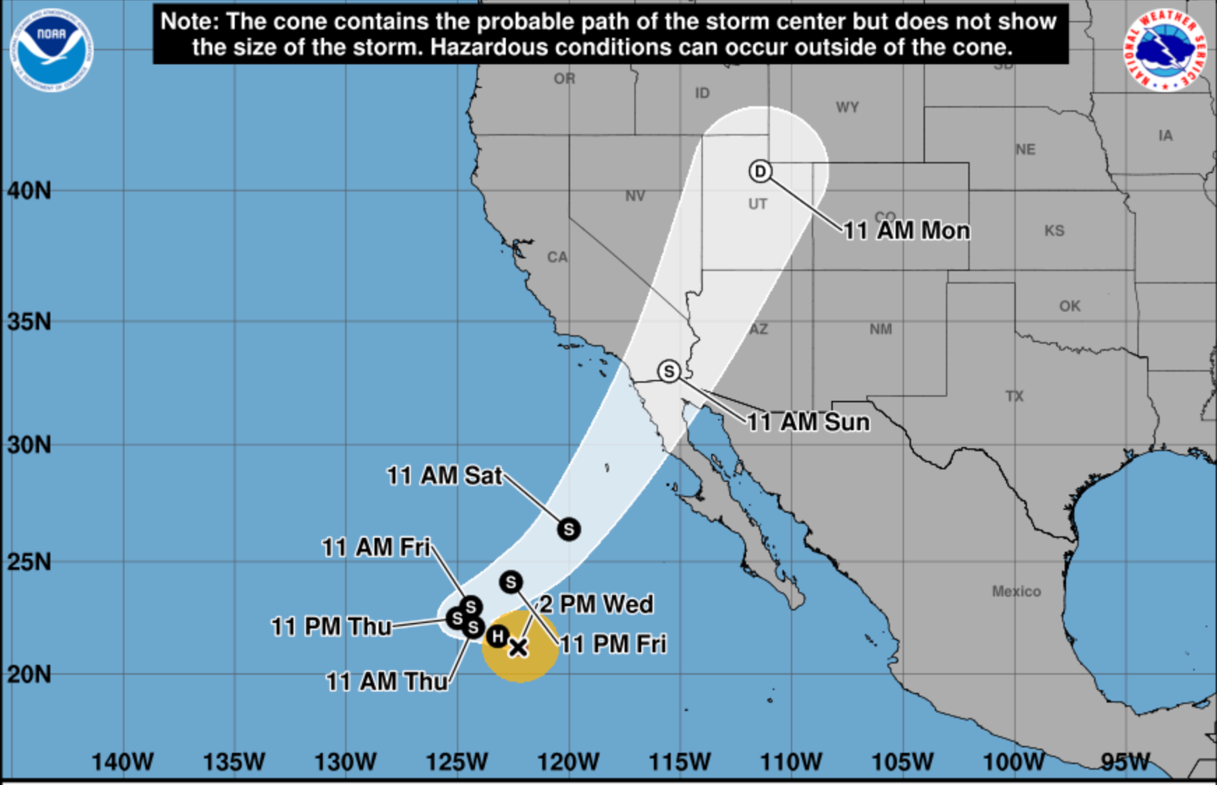
"Things are kind of trending a little bit further south than what they looked like a couple days ago," Lewis said. The National Hurricane Center expects Rachel to continue weakening as it approaches the region, although tropical moisture associated with the system could still produce rain across Southern California.
For LA County, Lewis said the most likely rainfall totals currently range from a quarter-inch to three-quarters of an inch, with greater amounts possible in the San Gabriel and Santa Monica mountains. There is also approximately a 10 percent chance of thunderstorms, although widespread inland flooding is not anticipated unless stronger showers or thunderstorms develop.
The approaching system will also bring a dramatic end to Southern California's October heat wave. According to the NWS Los Angeles/Oxnard office, temperatures that have reached 95 to 105 degrees in parts of the region Thursday are expected to fall into the 70s by Sunday or Monday. Rain chances could continue into Tuesday night, with the highest probabilities Sunday and Monday.
Despite Rachel's tropical origins, Lewis cautioned against comparisons with Tropical Storm Hilary, which brought historic rainfall to parts of Southern California in August 2023.
"It does not look like that at this point," he said. "Especially for our area, we'll see impacts a few steps down at least."
When Conditions Will Be Worst And How To Prepare
Although Rachel's precise track could still change, Lewis identified Sunday as the day when the greatest number of weather hazards could coincide.
"It looks like Sunday is probably going to be the worst of it in terms of the combination of everything: surf, tides, winds, even rain," he said.
The wheather is urging residents to monitor changing conditions, particularly those living or traveling near the coast. Officials recommend protecting vulnerable coastal property, avoiding flooded roads and staying away from exposed rocks and jetties as surf conditions deteriorate.
Lewis also warned that even relatively modest rainfall can cause localized street flooding in Southern California. "Never drive into flooded roads," he said.
For beachgoers, his advice was equally straightforward.
"Definitely staying out of the water is probably a good idea here with these elevated surf and significant winds coming up, as well as some pretty dangerous rip currents," Lewis said.
Residents can monitor Rachel's changing track and intensity through the National Hurricane Center and find the latest local forecasts, watches and warnings through the National Weather Service Los Angeles/Oxnard office.
Get more local news delivered straight to your inbox. Sign up for free Patch newsletters and alerts.