Weather
Temperature Drop Finally On The Way To LA As Tropical System Forms: See Timeline
The cooling will be accompanied by increased onshore flow and a return of marine-layer clouds.

LOS ANGELES, CA — Southern California will continue to cool down Monday before moisture from tropical storm Karina brings a chance of showers and thunderstorms Tuesday, while forecasters are also watching another possible tropical system that has a chance of developing into a hurricane near the region.
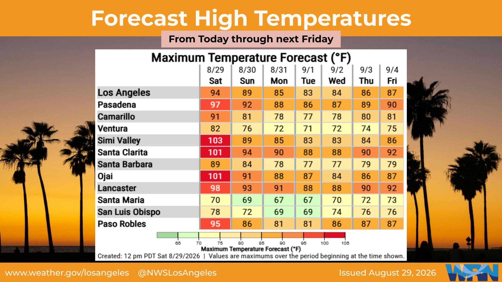
Temperatures Monday are expected to be 4 to 8 degrees below normal in most areas, with highs in the valleys only reaching the mid-80s to lower 90s, according to the National Weather Service.
The cooling will be accompanied by increased onshore flow and a return of marine-layer clouds. Forecasters said low clouds should become more widespread Monday morning, particularly along the Los Angeles County coast.
Find out what's happening in Los Angelesfor free with the latest updates from Patch.
Temperatures are not expected to change much Tuesday, but conditions will become more humid as subtropical moisture moves into the region.
"This subtropical moisture influx will lead to a 15 to 20 percent chance of showers and thunderstorms focused over LA County Tuesday afternoon and into the evening," forecasters said.
Find out what's happening in Los Angelesfor free with the latest updates from Patch.
National Weather Service forecasters say the chances of another tropical system in the Pacific Ocean developing into a hurricane that reaches near Southern California remain uncertain.
Temperatures in Los Angeles County should gradually rise from Wednesday through Saturday, although most areas will remain below normal, with the major exceptions of the Los Angeles County coast and San Gabriel Valley.
"It's all hypothetical still because the storm currently is just an area of disorganized thunderstorms off the Southern Mexico coast. However, the general forecast is that in the next 48 hours we'll expect tropical cyclone development as per the National Hurricane Center's forecast, and it'll continue to drift north and west," said David Munyan, a meteorologist for the National Weather Service in San Diego.
"From there, very, very significant amount of uncertainty about how close it will track to Southern California or whether or not it will stay south and curve west out into the Pacific, that's almost a 50/50 chance on whether it'll curve west or maybe stay closer to the coast and keep it on more northerly track instead of a westerly track. But even for those that northerly track, if that was to occur, it is fairly uncommon," he added.
"We have had tropical systems move in our direction before. We've had Hillary 2023, and I believe it was K a couple years prior to that. But the way that the ocean temperatures cool is you increase latitude and go further north. Tropical storms, hurricanes or not, usually fall apart and weaken. And it's only the remnants of those tropical systems that draw close to California."
City News Service contributed to this report.
Get more local news delivered straight to your inbox. Sign up for free Patch newsletters and alerts.