Weather
Seal Beach May Be Underwater In 30 Years, Coastal Scientists Say
What could Seal Beach look like in 2050? Flooded, covered in rising seas, according to a Sea Level Rise Vulnerability & Adaptation Workshop.


SEAL BEACH, CA — The sea may be calm, but it is reaching out to our shores, experts say. The city of Seal Beach constructs sand berms each winter to keep the king tides and huge waves at bay. Still, flooding projections say that a 1.6-foot sea level rise is possible, even likely, by 2050.
Worst case scenario? According to the Sea Level Vulnerability report, a 3.3-foot rise was expected by 2070, along with non-storm flooding, and by 2100? The water would rise by 6.6 feet, experts say. Nearby wetlands, such as San Gabriel River and Anaheim bay, will double in depth.
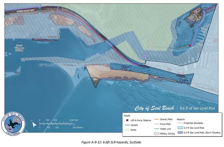
If that happened, Old Town Seal Beach would become an island, and those broad sandy beaches the town is famous for could disappear altogether.
Find out what's happening in Los Alamitos-Seal Beachfor free with the latest updates from Patch.
Best case scenario? Ocean rise would be roughly half what has the report predicted, the Coastal Commission has said.
That commission works to review Local Coastal Plans, and has recently opposed buildings planned for 17th Street, according to the Orange County Register report.
Find out what's happening in Los Alamitos-Seal Beachfor free with the latest updates from Patch.
Residents, while concerned, were wary of the figures presented to them at the Marina Community Center.
"We want to make sure we’re not underestimating future sea-level rise because the consequence to coastal resources, development, life, and safety could be severe," commission spokeswoman Noaki Schwartz told the Register.
The city of Seal Beach will need to continue developing their Local Coastal Plan, and their state-mandated climate adaptation plans, she said.
Get more local news delivered straight to your inbox. Sign up for free Patch newsletters and alerts.