Politics & Government
Ballona Wetlands: The Christmas Week Storms of 2021
Though the December 20-25 rainstorms seemed to go on forever, they didn't cause a big flood in Ballona Creek

[Please scroll to the end for author's affiliations.]
Perhaps because we've been experiencing such a painful drought over the past several years, the recent rainstorms in December felt epic. Indeed, Los Angeles received well over a week of nearly continuous rainfall prior to and through Christmas Day. It was a steady, light to moderate rain, with a few periods of heavy downpours. It’s been bone dry since then.
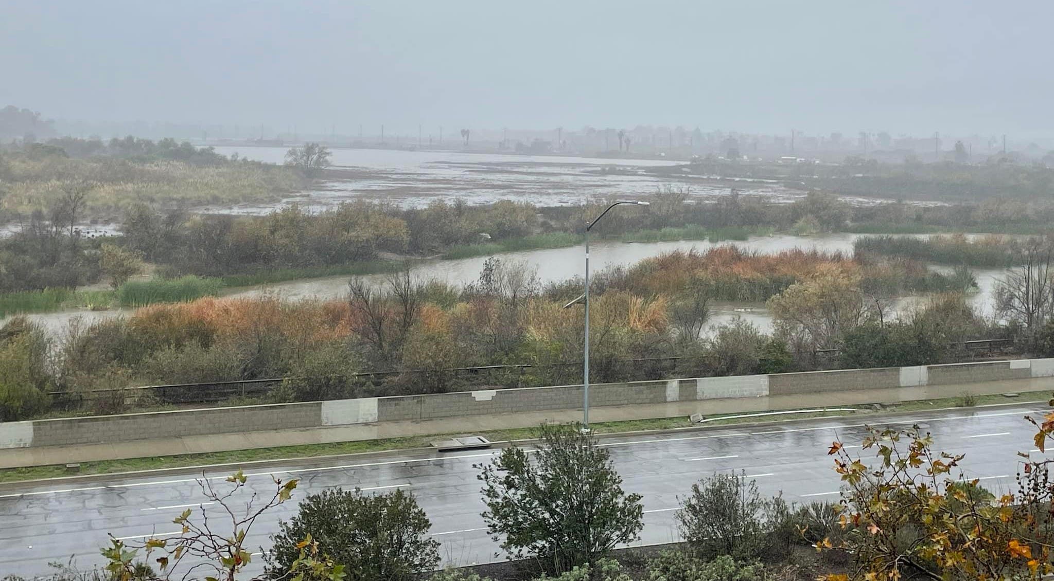
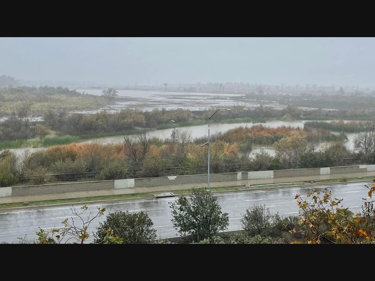
Above: The Ballona Freshwater Marsh and Ecological Reserve Area B on 12/29/2021. Photo by Deborah Doll-Breindel.
Find out what's happening in Marina Del Reyfor free with the latest updates from Patch.
The photo above shows rainwater accumulating in the southeastern Ballona Wetlands during this period. While this rain helps the wetlands vegetation in the short term, over the long term it would degrade the historical habitat.
The native vegetation here is salt-tolerant and the soils hypersaline from historical tidal flushing over centuries. Tide gates in the Ballona Creek concrete banks, closed during large storm runoff and high tides, hold back this fresh water for a brief time before letting it drain to the Ballona Creek channel.
Find out what's happening in Marina Del Reyfor free with the latest updates from Patch.
The Department of Fish and Wildlife's proposed Ballona Wetlands Restoration Project will remove these tide gates, restore tidal flushing and maintain hypersaline soil conditions.
The National Weather Service records water surface elevations in Ballona Creek at a gauging station at Sawtelle Blvd. While this station does not capture the additional flow from Centinela Creek, its measurements represent over 95% of Ballona Creek's storm flow. The graph below shows the water surface elevation changes recorded during that wet week spanning Christmas.
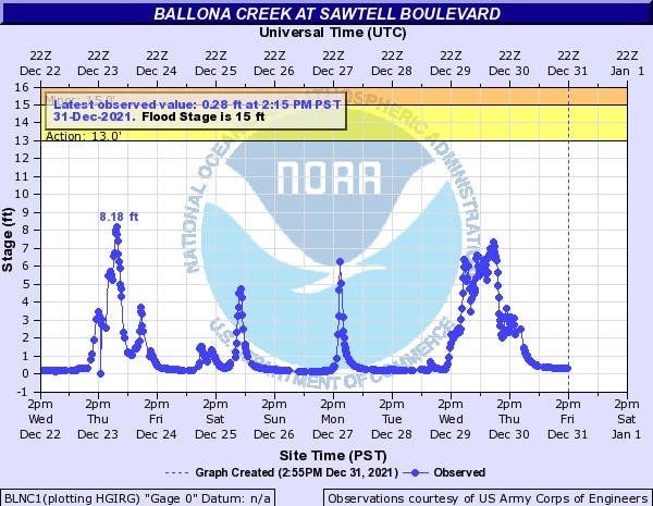
The highest water surface elevation during the week was 8.18 feet above channel bottom on 12/23, but the peak on 12/29-30, although slightly lower, had a longer duration. The 12/23 runoff event produced the larger instantaneous flow.
The table below, produced by the Los Angeles County Department of Public Works, converts the NWS water surface elevation data into water flow results. This table shows the peak flood flow rate that week, measured in cubic feet per second (cfs), reached 10,008 cfs on 12/23 at 9:55 PM.
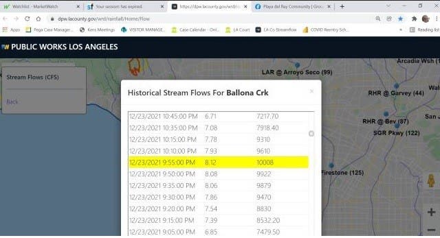
While this number may feel large, it is only slightly larger than the typical 1-year return storm flow of 7,769 cfs. The 1-year return value is that storm flow which is likely to occur every year, based upon historical records. For comparison, the larger 5-, 10- and 50-year flood return flows are 17,660, 22,000 and 32,140 cfs, respectively. So, our December 23rd storm was perhaps a 2-year return storm flow.
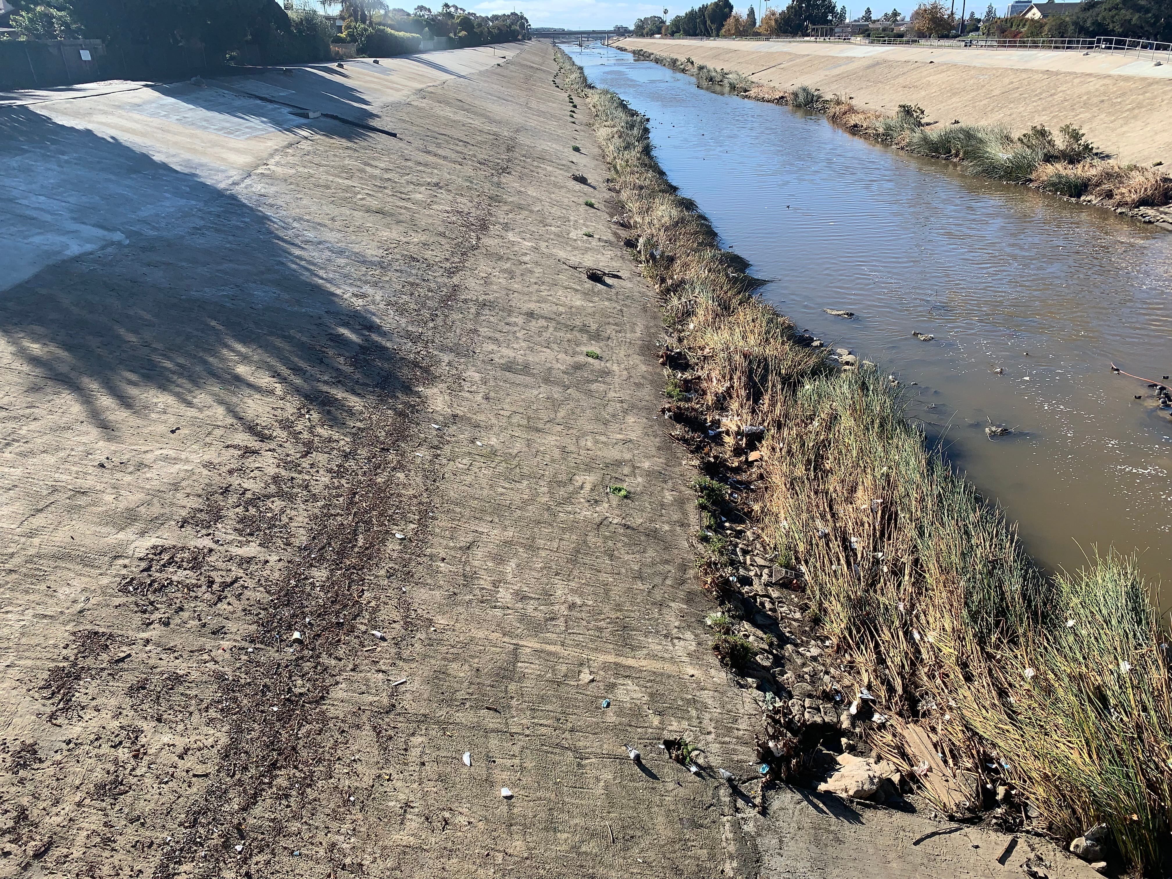
The image above shows the debris line recording the high water mark in Ballona Creek at Centinela Avenue, taken on 12/31/2021, a few days after the Christmas week storms ended. Only a fraction of the flood control channel's capacity was used. Such channels were typically designed to hold the flood flow from a 100-year storm, plus a factor of safety.
Back in 2014, Friends of Ballona Wetlands commissioned a study of Ballona by a renowned river hydrologist, Dr. Howard Chang of San Diego State University. An expert in river flood scour, Dr. Chang created the FLUVIAL-12 model, used worldwide to accurately predict how high water levels will reach during a given river flood and how the flood will scour the river's channel. In the 2014 study, Dr. Chang applied FLUVIAL-12 to an 1876 map of the Ballona Wetlands, shown below, created by the predecessor agency of the U.S. Geological Survey.
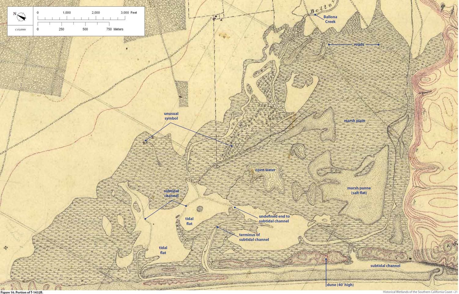
Above: The Ballona Wetlands as mapped in 1876. Later maps provided land elevations.
Using the historical records of flood flows from the Sawtelle Avenue gauging station, Dr. Chang used FLUVIAL-12 to calculate how various Ballona Creek floods would have scoured the creek's channel back in 1876, including the channel's tidal inlet where it crossed the beach (south of today's Cafe Pinguini). The model output for a typical 1-year return period storm, picked from the Sawtelle Avenue gauging station records, is shown below for the 1876 beach inlet in Playa Del Rey.
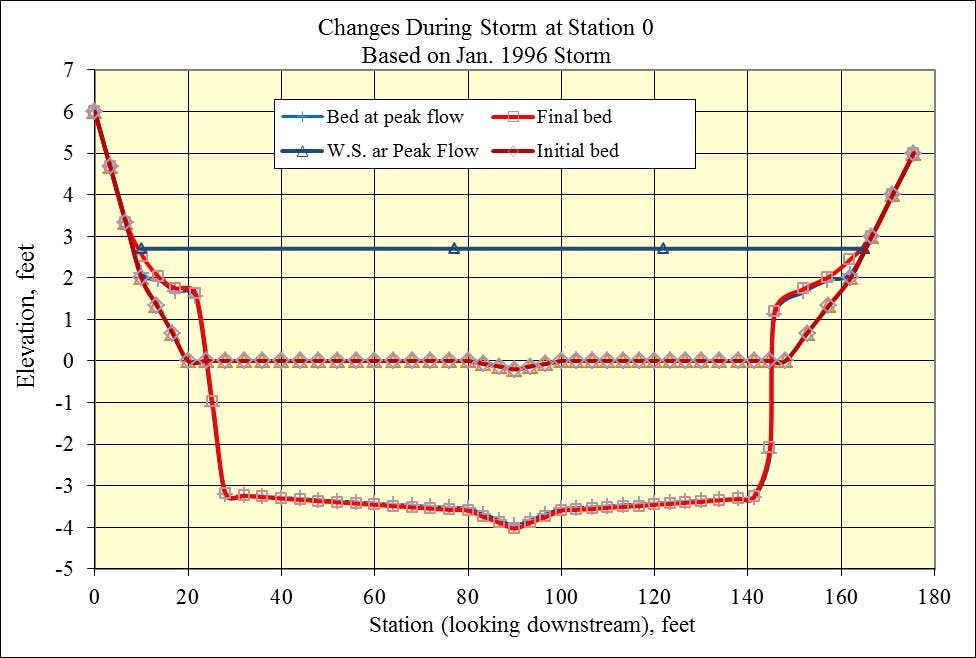
What the diagram above shows is that the typical 1-year return period storm (somewhat smaller than we experienced this past Christmas week) would have scoured the 175-foot wide sandy tidal inlet of Ballona Creek, where it crossed the beach back in 1876, down to -4 feet elevation (about 4 feet below mean sea level).
Once the rainy season ends here around March-April, the 1876 tidal inlet channel at the beach begins to fill back in with sand. Incoming tides, enhanced by wave action, deposit a little more sand into tidal inlets than the ebb tide flows can scour back out. So, over time, there is a net accumulation of sand in the inlet.
According to studies on other tidal inlets in Southern California (Jenkins et al.), the 1876 Ballona tidal inlet would take 6-9 months to fill back in with sand, and close. In years with larger storm flows, such as 5- or 10-year return period floods, the inlet would not close at all before the next winter's rains scoured it out again. In any case, the Ballona tidal inlet would only close late in the year, if at all, and then be scoured open again by the first large winter storm flows in the creek.
What this all means is that the Ballona Wetlands were almost always open to daily tidal flushing with salty seawater, twice each day, when the moon spoke to the sea.
The Christmas week storms also caused a healthy flood flow in Malibu Creek. Malibu Creek serves as the tidal inlet for the Malibu Lagoon, a miniature version of the Ballona Wetlands. The Christmas week storms scoured down the sandy beach berm at Malibu on which beach lovers congregate year round. The photos below don’t show how far downward the flood flow scoured the inlet, but do show the width of scour. Since Malibu Creek carries lots of sediment when it floods, that sediment deposits and reduces the final depth of scour as the flood recedes. The FLUVIAL-12 model accounts for this sediment "refilling" of a river channel as a flood episode ends, so the model does not overestimate scour.
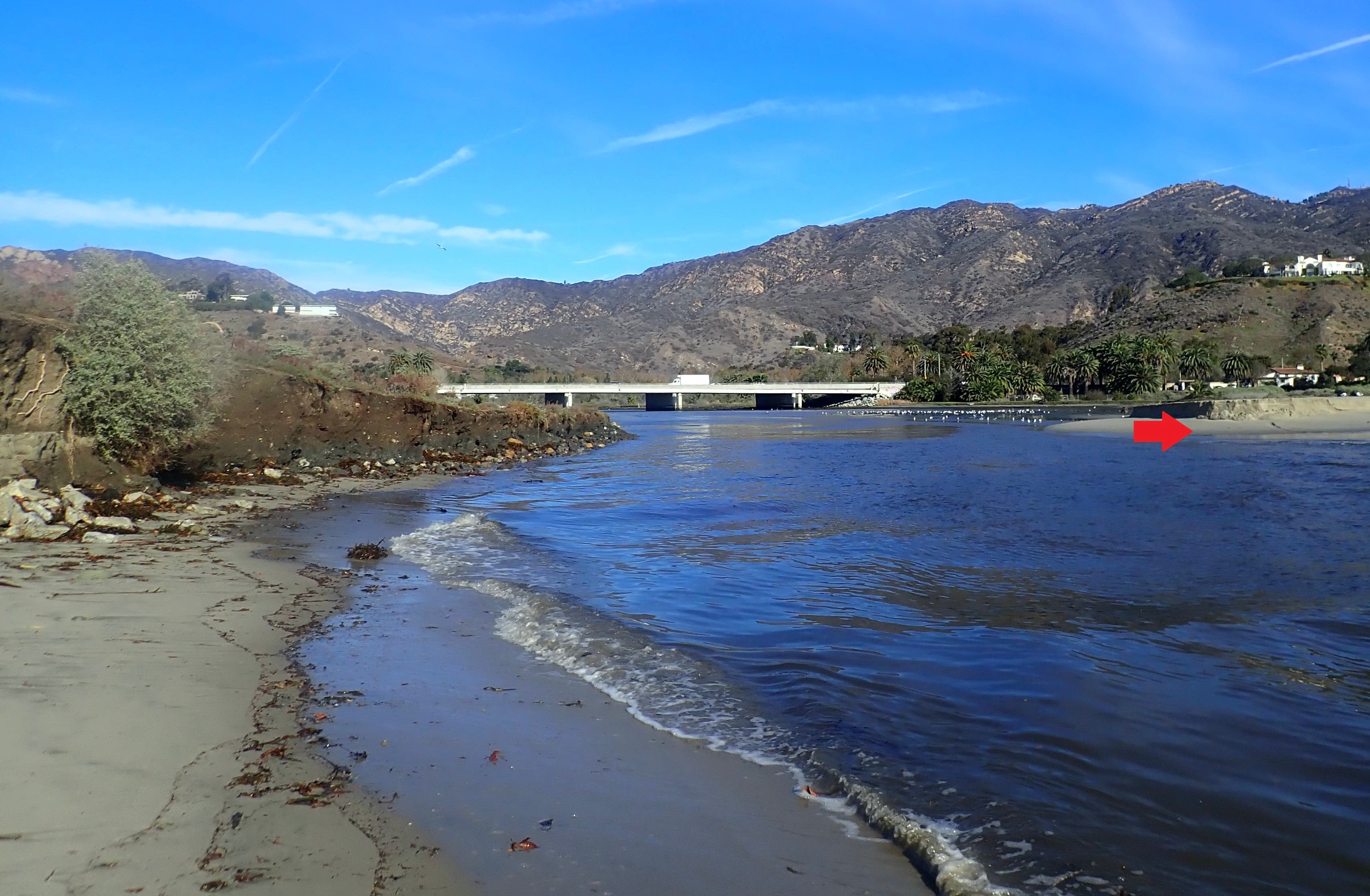
Above: The Christmas week storms scoured a very wide and deep tidal channel through the beach berm at Malibu Lagoon. The scarp shown at the red arrow gives a clue about the depth of downward scour. Photo courtesy of Rosi Dagit, RCD of the Santa Monica Mountains.
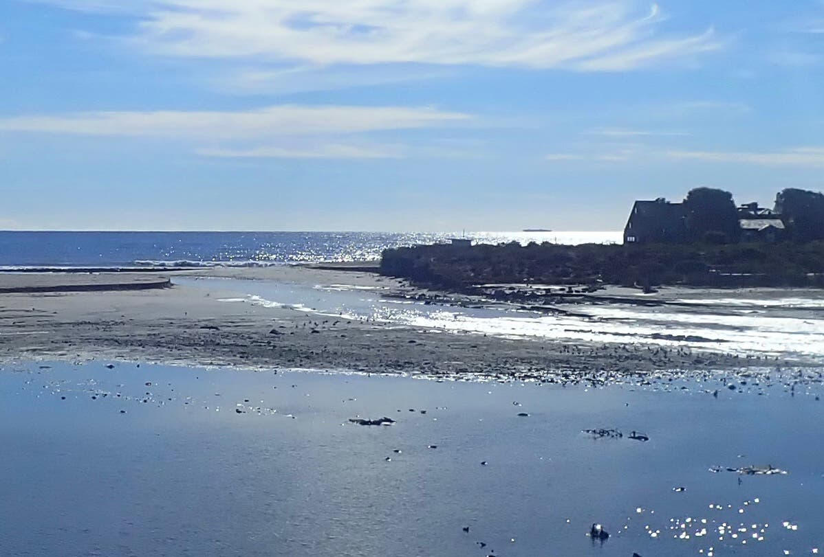
Above: The main tidal channel at Malibu Lagoon. The Christmas week flood obliterated the beach berm, which will likely take months to return. Photo courtesy of Rosi Dagit, RCD of the Santa Monica Mountains.
It will be instructive to watch how long it takes in 2022 for the Malibu Creek tidal inlet to close.
References
1. Ballona Wetlands Restoration Project final EIR/EIS. California Department of Fish and Wildlife. https://wildlife.ca.gov/Region...
2. National Weather Service. Advanced Hydrologic Prediction Service. Ballona Creek at Sawtelle Blvd. gauging station. https://water.weather.gov/ahps...
3. L.A. County Department of Public Works. Streamflow Data. https://dpw.lacounty.gov/wrd/r...
4. Fluvial Study for Ballona Creek Estuary. Prepared for Friends of Ballona Wetlands. P. O. Box, 5189, Playa del Rey, CA 90296. Prepared by Howard H. Chang, Ph.D., P.E. February 2014. Chang Consultants. P. O. Box 9492, Rancho Santa Fe, CA 92067.
5. Jenkins, S.A and J. Wasyl 2001. Tidal Hydraulics of the Final Plan for the San Dieguito Lagoon Restoration. Dr. Scott A. Jenkins Consulting. Also, various prior studies supporting EIR/EIS, 2000, Environmental Impact Report/Environmental Impact Statement for the San Dieguito Wetland Restoration Project. State Clearinghouse No. 98061010.
3. Ballona Wetlands Preview: Malibu Lagoon's Resounding Success. Marina Del Rey Patch. September 26, 2019. https://patch.com/california/m...
Author's note on affiliations:
Dr. David W. Kay served on the Board of Directors of the non-profit Friends of Ballona Wetlands from 2007 until 2015, and served as Board President in 2012-13. He presently serves on the Board of Ballona Discovery Park in Playa Vista. David is a staunch advocate for the state of California's plans to restore the Ballona Wetlands Ecological Reserve.
Since 1984, David has been employed by Southern California Edison Company, exclusively in the company's environmental services organizations. His many responsibilities included restoration of the 440-acre San Dieguito Wetlands near Del Mar. He is presently Senior Manager for Major Project Environmental Management at the company.
David earned bachelor and masters degrees in biology and a doctorate in environmental science.
See David's Patch Community Contributor profile here.