Politics & Government
Ballona Wetlands Hydrology: Hard Science Made Softer
Before the 1900s, Ballona Wetlands Were a Shallow, Tidal Saltmarsh, Always Open to the Sea. Modern Forensic Hydrological Modeling Proves It


In a previous Patch article, I explained how pre-historic shell piles created by Native Americans showed the Ballona Wetlands were saltwater, tidal marsh open to the sea going back at least a thousand years. The exclusively saltwater Venus Clam, Chione, dominated these shell stockpiles. Other contemporary evidence also supports a historic saltwater Ballona environment.
Most of the original 2000-acre Ballona Wetlands were gradually filled in since the early 1900s, first by agriculture and grazing, later oil and gas production, and during the 1950-60s by Marina Del Rey and Marina Freeway construction waste disposal. The State of California purchased all of the remaining open land, around 600 acres, and designated it Ecological Reserve. California proposes to dig out and restore the infilled portions of lands to create and enhance a mix of saltwater tidal, brackish, freshwater and upland habitats, accessible by extensive public trails and paths. The photo below at left center shows the northern half of the wetlands being filled with mud dredged from Marina Del Rey construction. Today the area is covered with 12-17 feet of dry, weedy fill dirt.
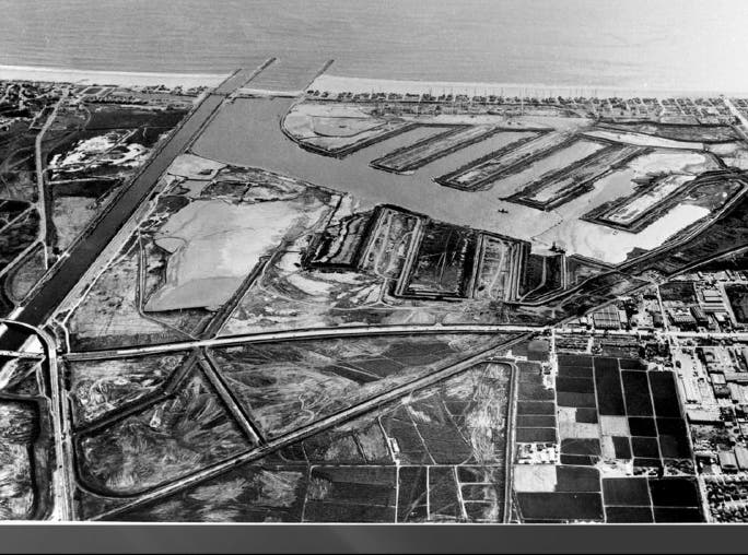
Above: Marina Del Rey construction, around 1960. Hydraulic dredging spoils were pumped into a fenced 200-acre area, shown just left of center, where they drained and compressed as they dried out.
Find out what's happening in Marina Del Reyfor free with the latest updates from Patch.
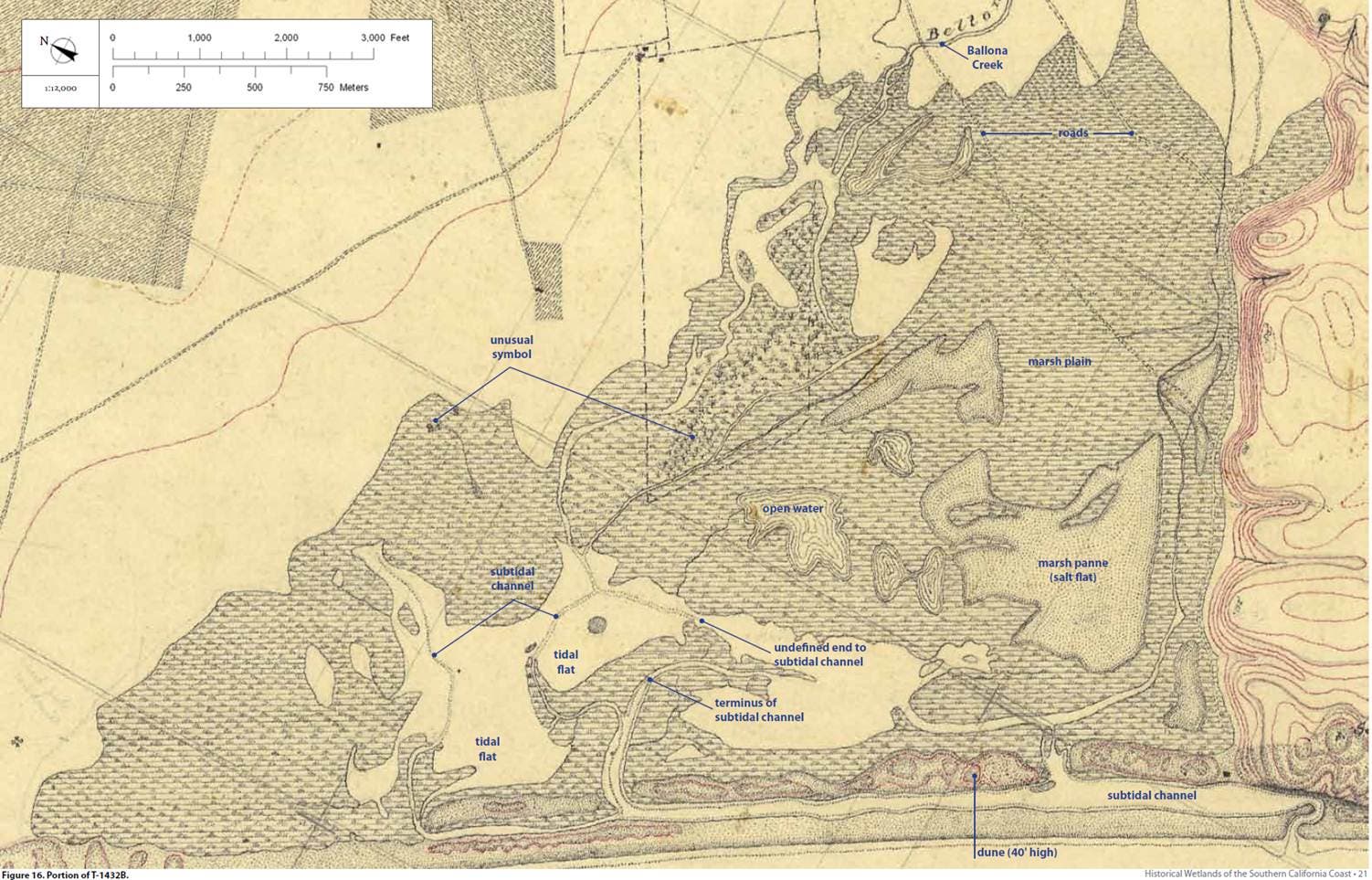
The Ballona Wetlands historically covered over 2000 acres, stretching from the Westchester Bluffs north to present-day Venice Beach, and east to Lincoln Blvd. The earliest reliable map of the Wetlands is an 1876 U.S. Coast Survey map (see below).
Up until 47 years before this map was made, the Los Angeles River flowed to the ocean through Ballona into Santa Monica Bay and Ballona Creek was merely one of its tributaries. A flood in 1825, changed the course of the river — relocating its mouth from Santa Monica Bay to Long Beach. So, this map represents Ballona not long after that change occurred. The Ballona Creek watershed drains 130 square miles, while the L.A. River drains 580 square miles. The typical winter storm runoff flow to the Bay from the Los Angeles River before the 1825 flood was roughly 80% larger than the typical Ballona Creek storm flow of today.
Find out what's happening in Marina Del Reyfor free with the latest updates from Patch.
The upper right hand corner of this map is where present day Lincoln Boulevard slopes downhill toward the north from Westchester. This map and later updates provided data for a modern “forensic” hydrological modeling of the wetlands and their historic tidal inlet across the beach.

The 1876 map above shows a tidal inlet across a soft sandy beach at lower right, approximately 160 feet wide. This tidal inlet is also the mouth, or outlet, of Ballona Creek, where the creek flows into the ocean. The inlet would have been much deeper and wider before the 1862 flood changed the Los Angeles River's course.
The inlet flows out of a subtidal channel landward of and parallel to the beach, known today as Ballona Lagoon. This channel is in fact the Los Angeles River's prehistoric channel, forced to turn southward by downcoast beach sand migration. From this map, you can see how much wider this channel is than the beach inlet, documenting the scouring power of the pre-1825 river flood flows. The "sand spit" that forced the river to make a 90 degree left turn to the south is a typical topography found in historical and some present day undisturbed southern California tidal wetlands. Standard symbols in this map show marsh conditions along nearly 2 miles of coastline, extending irregularly landward about 1.5 miles to the confluence of Ballona Creek.
In a later 1934 map shown below, the U.S. Geological Survey shows the Ballona Wetlands' areal extent largely unchanged from the 1876 map. However, the tidal inlet is shown on this map to be confined by rock jetties, Ballona Creek is shown channelized to the approximate location of present-day Lincoln Boulevard, the Venice Canals had been developed and roads and railroad infrastructure had been built across the southern third of the wetlands area. The subtidal channel landward of the beach is labeled Ballona Lagoon on this map, which still exists today north and south of the Marina Del Rey main channel. The bottoms of subtidal areas are below sea level, so they never completely drain at low tide. Ballona Lagoon's subtidal condition resulted from repeated downward scour of the channel bottom by the Los Angeles River's annual winter storm flood flows.
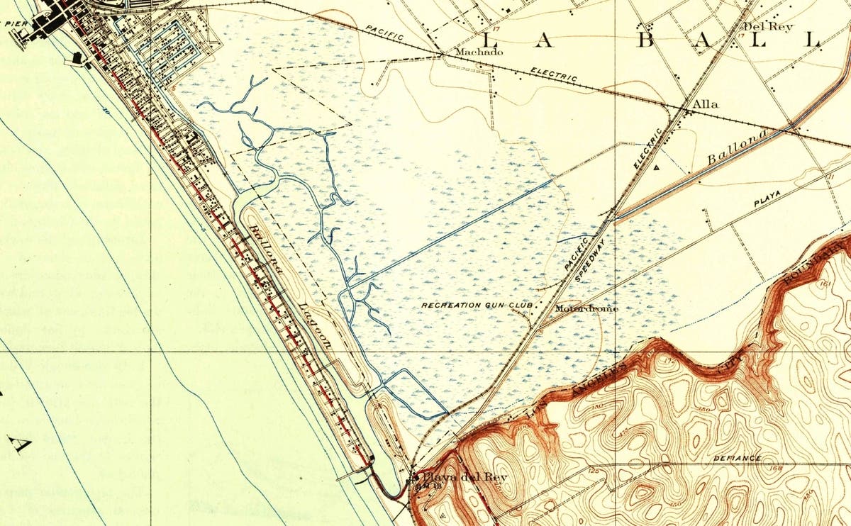
Above: The USGS 1934 topo map shows land elevations below the high tide line throughout the entire Ballona Wetlands estuary.
The 1934 map surveyors established elevation contour lines and document a single continuous contour of elevation +5 feet surrounding the Ballona Wetlands (that's about 5 feet above Mean Sea Level). This 5 foot elevation line is important, as it establishes that all lands within the 5 foot contour were at elevation 5 feet or lower. Since southern California high tides typically exceed 6 feet in elevation, all coastal lands at or below around 5 feet elevation, and which have an ocean connection, become saltwater tidal wetlands.
A few years ago, Dr. Howard Chang, an expert river hydrologist and Professor Emeritus of Engineering at San Diego State University, applied his world-renowned river flood and scour model, known as FLUVIAL-12, to the 1876 Ballona conditions (1). Dr. Chang’s FLUVIAL-12 computer model very accurately predicts how a river or creek’s flood flow will scour the river's own channel bed and banks all the way to its mouth. Since the federal government kept decades of records of Ballona Creek’s flows at the Centinela Avenue Bridge during all seasons, Chang had very reliable measurements of the Creek’s typical winter storm flood flows for input into the modeling run.
To model Ballona using FLUVIAL-12, Dr. Chang used data from a fairly typical mid-winter rain storm from January 1996, which produced runoff flows in Ballona Creek that rose and peaked to 9,500 cubic feet per second (cfs), then fell again over a six-hour period as the flood subsided (see hydrograph below). Much larger and smaller storm flows are recorded for Ballona Creek, but 9,500 cfs is typical for a mid-winter Pacific storm during a normal rainfall year, and so would have been typical 140 years earlier in 1876. Dr. Chang also assumed the 1876 sandy beach mouth of Ballona Creek rested at around 0 feet elevation (zero, or around Mean Sea Level), which again is typical of such river mouth tidal inlets observed today along the southern California coastline.
In 1876, of course, the entire Ballona Creek watershed up to the Hollywood Hills was undeveloped earthen land, easily eroded by rainfall runoff’s scouring forces. Even though the land was not paved over like today, once early storm fronts saturated the surface soil, all subsequent rainfall would run off as if the ground were impervious. Flood flows would carry eroded sediments towards, and eventually into the ocean at the shoreline, nourishing the beach with sand.
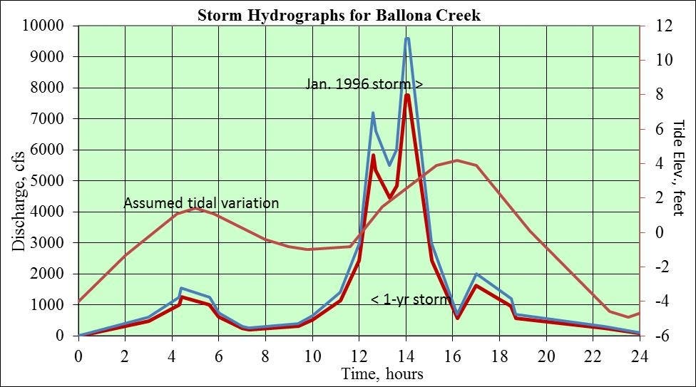
Above: Storm hydrograph for Ballona Creek at Centinela Avenue, showing the January 1996 storm flow, as well as the 1-year return period storm.
Dr. Chang’s model results for the Ballona Creek sandy beach inlet are shown in the figure below. Looking at this figure, imagine you are standing in the inlet channel 140 years ago, looking at the ocean through the gap where the channel cuts through the sandy beach. Left to right you see the south-to-north cross-section channel bed elevation at the beach inlet. The dark red line shows the channel bed cross-section shape at the beginning of the storm (the initial bed), while the bright red line shows the shape at the end of the storm, the final bed. You can see how the inlet channel depth changes from before, to after the storm by comparing these two lines against the measuring scales at bottom and left (in feet).

Above: FLUVIAL-12 model output showing Ballona Creek channel cross section at the beach from the January 1996 storm. Chang, 2014.
Before the storm, the inlet across the beach was at 0 feet in elevation and about 160 feet wide. At the end of the 9,500 cfs sediment-laden storm runoff event, six hours later, the inlet channel is scoured downward to a depth of -4 feet elevation (about four feet below Mean Sea Level). If you imagine pouring a toy bucket of water over a sand castle, you understand how easily the storm’s runoff scoured the soft sandy tidal inlet so deeply. Larger storms would scour the inlet channel even deeper, up to 8 feet downward for a 10-year storm flood event and 10 feet deep for a once in fifty year storm, according to the FLUVIAL-12 model run. Chang’s model produced similar figures for each cross-section of Ballona Creek, including the subtidal Ballona Lagoon, all the way upstream to Centinela Ave., and for any magnitude storm return period.
One reason Dr. Chang’s model is considered so precise, is that it predicts not only the earth scoured out of a river’s bed by the rising storm flow, but also predicts how the river re-deposits eroded sediment carried by its own flood waters back into its own channel as the flood flow subsides. So, the model does not over-predict channel scour. For this reason, the model is used worldwide to predict not only river flood scour, but also the rising and falling of the flood water surface elevation throughout the duration of a flood event.
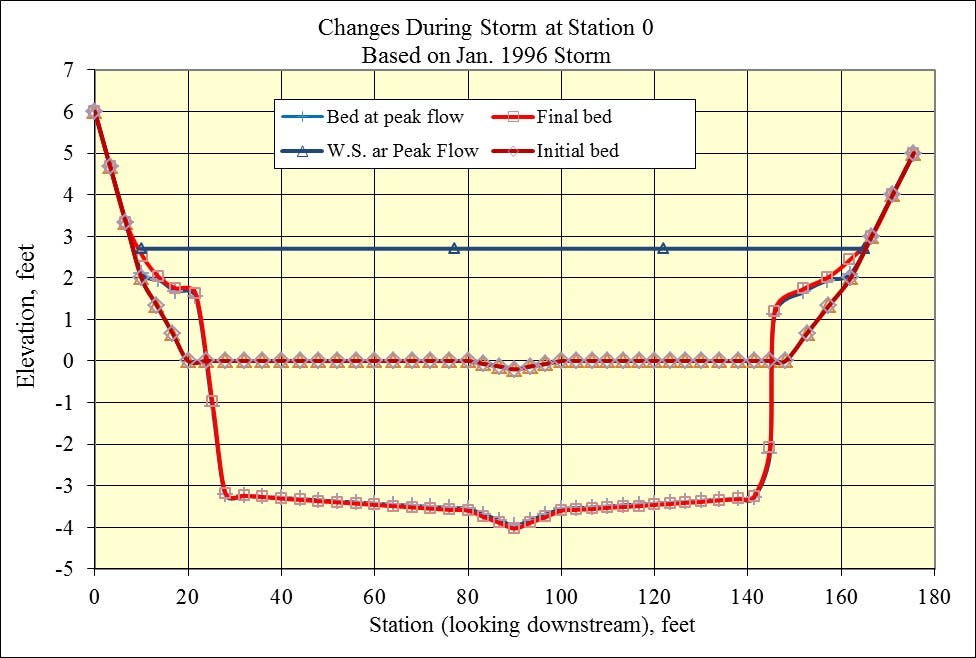
Back to the figure above. Imagine now the moon's gravitational force lifting the high tide up to +5 feet following this hypothetical 1876 mid-winter storm. With the inlet channel now scoured down to -4 feet elevation, a rising wall of ocean 9 feet deep and 160 feet wide flowed through the inlet at a speed of 3 feet/second into the Ballona Wetlands, filling up the wetlands area until the tide began to reverse and fall six hours later (2). The incoming ocean water would reach the most distant marsh plants near present day Lincoln Blvd. Alternating every six hours thereafter, the rising and falling tides flowed in and out of the sandy inlet, keeping it scoured open, refreshing the salt-tolerant wetlands vegetation, and invertebrates like the Venus Clam, with seawater. Fish swam into the wetlands during post-storm high tides and spawned in the protective, shallow Ballona Lagoon just behind the beach, their fry eventually swimming out months later into the ocean to continue the circle of life. Birds feasted on the unlucky ones.
Simply looking only at the 1876 map above, one's intuition suggests so much seawater couldn't possibly flow in and out of a tidal inlet which visually appears so relatively small on the map. But in reality, the inlet is neither small nor shallow, and the mathematics prove that the moon's tidal forces can indeed push 326 million gallons of ocean through the inlet every day, twice a day. Watch this great time lapse video of the incoming tide at Ballona: Click Link
So, how long would the storm-scoured sandy inlet have remained open to the ocean back in 1876? We know that sand lapping up onto the beach with summer surf and migrating downcoast along the shoreline will eventually fill in a scoured inlet channel. Another southern California scientist (affiliated with Scripps Institution of Oceanography), Dr. Scott Jenkins, is an expert on the dynamics of tidal flows into wetlands and estuary areas. Dr. Jenkins also uses precise mathematical modeling to predict how far beyond a wetland’s beach inlet the incoming tides will flow, and also how long it will take before the beach inlet fills in with transported sand.
Using the output from Dr. Jenkins’ modeling of the very similar San Dieguito Wetlands near Del Mar, California (3), one could conservatively estimate that during the 1800s, it would take 8-12 months before the flood-scoured Ballona Creek tidal inlet would fill back in with 5-7 feet of beach sand, potentially blocking out the incoming tides. For 10- or 20-year flood event inlet scour, inlet closure by sand deposition would take much longer; well over a year.
This means if the 1876 Ballona Creek beach tidal inlet channel were scoured out during the rainy January-March time frame every year, it wouldn't fill back in with enough sand to close up until the following September-December period, 8-12 months later, at the earliest. By then, fresh water inflow from the hot and dry Ballona Creek watershed was reduced to a trickle, and so could not have diluted the massive volume of seawater trapped in the 2000-acre wetlands. Furthermore, winter storms are already forming in the Gulf of Alaska in fall, preparing to pound southern California during the imminent rainy season and begin the inlet's flood scouring process all over again. So, except for a rare month or two at a very dry year’s end, the historical Ballona Wetlands always stayed open to the Pacific Ocean’s refreshing saltwater tides, nourishing the wetlands' flora and fauna twice each day, when the moon spoke to the sea.
Enjoy your Ballona Wetlands!
References
(1) Chang, H.H. 2014. Fluvial Study for Ballona Creek Estuary. Chang Consultants.
(2) 9 ft. x 160 ft. = 1440 sq. ft.; 1440 sq. ft. x 3 ft./sec tidal velocity = 4,320 cfs.; 4320 cfs x 3 hours incoming tide = 47,000,000 cubic feet of water, or 326 million gallons. That’s enough to cover the entire 2000 acres of the historic Ballona Wetlands with 1/2 foot of water.
(3) Jenkins, S.A and J. Wasyl 2001. Tidal Hydraulics of the Final Plan for the San Dieguito Lagoon Restoration. Dr. Scott A. Jenkins Consulting. Also, various prior studies supporting EIR/EIS, 2000, Environmental Impact Report/Environmental Impact Statement for the San Dieguito Wetland Restoration Project. State Clearinghouse No. 98061010
(4) L.A. County Flood Control District. History of the Los Angeles River. https://ladpw.org/wmd/watershe...