Weather
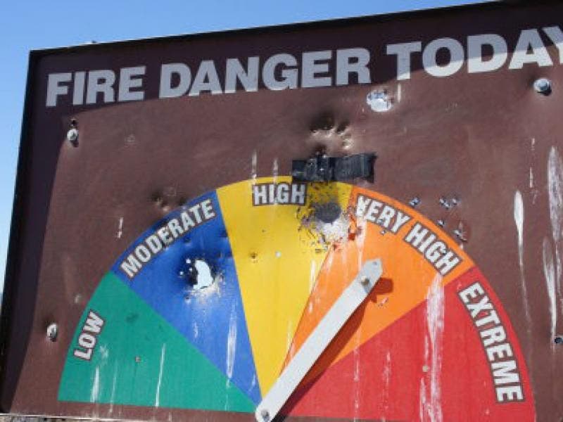
Fire Danger Elevated to Extreme for Montrose-La Crescenta, San Gabriel Mountains
A fire weather watch will be in effect from Wednesday afternoon through Saturday afternoon in the San Gabriels and Angeles National Forest.
LOS ANGELES, CA -- Gusty northwest winds again will sweep the San Gabriel Mountains and Antelope Valley on Tuesday, maintaining an elevated danger of fire, but the threat will become "extreme" Wednesday with an expected drop in humidity levels, the National Weather Service warned.
The areas most seriously affected Tuesday again will be the Interstate 5 corridor in the San Gabriels and the western tier of the Antelope Valley, with gusts of between 35 and 50 miles per hour expected, according to an NWS statement.
"The main impact through Wednesday morning will be elevated fire danger, especially considering the extremely dry fuels," the statement said, setting the stage for a replay of Monday's conditions. But it also pointed to a new wrinkle.
Find out what's happening in Montrose-La Crescentafor free with the latest updates from Patch.
"There is the potential for extreme fire danger starting Wednesday afternoon, as humidity values drop into the teens and single digits in the mountains. Other impacts may include reduced visibility in the Antelope Valley due to blowing dust, along with gusty crosswinds for high profile vehicles," it said.
In the San Gabriel Mountains, a wind advisory was scheduled to be in force until noon Tuesday. A fire weather watch, which is a notch less severe than a red flag warning, will be in effect from Wednesday afternoon through Saturday afternoon in the San Gabriels in L.A. and Ventura counties, the national forests that cover those mountains, the Santa Monica Mountains Recreational area, and the San Fernando and Santa Clarita valleys.
Find out what's happening in Montrose-La Crescentafor free with the latest updates from Patch.
Off the coast, a small craft advisory was scheduled to be in effect until 11 p.m. Tuesday, with NWS forecasters warning of brisk northeast winds gusting to between 20 and 25 knots per hour, and combined seas of 6 to 8 feet with a swell period of between 7 and 9 seconds, all producing steep waves.
"Inexperienced mariners, especially those operating smaller vessels, should avoid navigating in these conditions," a statement warned.
The NWS forecast sunny skies in Los Angeles County on Tuesday and highs of 70 on Mount Wilson; 74 in Avalon; 75 at LAX; 77 in Long Beach; 78 in downtown L.A., Palmdale and San Gabriel; 79 in Burbank and Lancaster; 80 in Saugus; 81 in Pasadena; and 82 in Woodland Hills. L.A. County highs will rise by a few degrees Wednesday and by several more Thursday, remaining in the 90s at least through Monday in some communities.
Sunny skies were also forecast in Orange County, along with highs of 72 in San Clemente; 73 in Newport Beach; 75 in Laguna Beach and Mission Viejo; 76 in Anaheim; 77 in Irvine and Fullerton; and 78 in Yorba Linda. Temperatures will generally stay the same Wednesday but climb by as much as 10 degrees in some communities Thursday, and by a few more degrees Friday and Saturday, piercing the low 90s before reverting to the 80s Sunday and Monday.
-- City News Service, photo credit: Renee Schiavone/Patch