Weather
108 Degrees In Murrieta Forecast As 'Dangerous' Heat Wave Hits Region, NWS Says
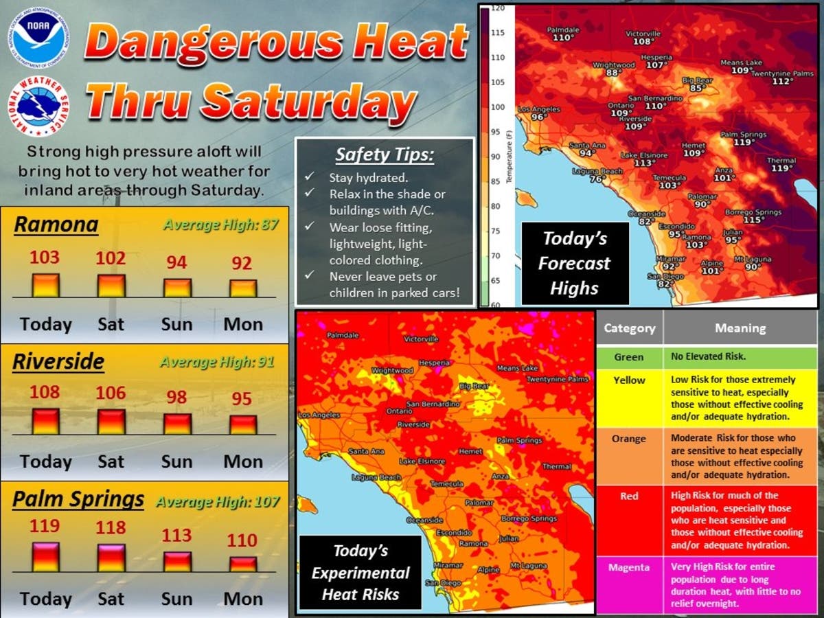
It was already 84 degrees in town by 9:30 a.m. Friday, as the NWS says temps will reach 115-120 in the lower desert and 110-114 in the I.E.

MURRIETA, CA – A spell of extra-hot weather will send temperatures across Murrieta and Riverside County soaring Friday into the weekend. By 9:30 a.m. Friday, it was already 84 degrees in parts of Murrieta, National Weather Service data showed.
"It's heating up in the desert this morning with some spots already surpassing 100 degrees as of 8 a.m.," the NWS said in a forecast discussion Friday morning. "The absence of a humid surge of air from the Gulf of California in the lower desert has allowed for this quicker warmup today."
An NWS excessive heat warning for the Temecula and Elsinore valleys, the San Gorgonio Pass zone, which includes Banning and Desert Hot Springs, the Coachella Valley and the valleys around Riverside is set to take effect at 11 a.m. Friday and extend until 9 p.m. Saturday. A less severe heat advisory for the mountains will run concurrently.
"Temperatures will reach 115-120 in the lower desert and 110-114 in the Inland Empire and high desert," the agency said. "Today is expected to be hottest in the lower desert as a gulf surge is expected during the mornings this weekend. That will mean more humid air tempering the heat, but not the comfort level."
Some of the high temperatures expected Friday include: 101 degrees in Anza; 104 degrees in Temecula; 108 degrees in Hemet; 109 degrees in Riverside; 113 degrees in Lake Elsinore; 119 degrees in Palm Springs; and 119 degrees in Thermal, according to the NWS.

On Saturday, highs will range from 105 to 112 degrees in Riverside and the surrounding valleys, 94 to 101 degrees in the mountains, 112 to 117 degrees in the San Gorgonio Pass zone and 113 to 118 degrees in the Coachella Valley.
Cooler conditions are expected to prevail early next week, but isolated afternoon thunderstorms that will increase the risk of dry lightning may develop over the mountains, with the greatest potential Sunday.
Here's the full forecast from the NWS for Murrieta for the coming days:
Today
Mostly sunny, with a high near 108. Light and variable wind becoming southwest 5 to 10 mph in the afternoon. Winds could gust as high as 20 mph.
Tonight
Partly cloudy, with a low around 69. Southwest wind 5 to 10 mph becoming light and variable in the evening. Winds could gust as high as 20 mph.
Saturday
Mostly sunny, with a high near 108. North wind 5 to 15 mph becoming southwest in the morning. Winds could gust as high as 20 mph.
Saturday Night
Partly cloudy, with a low around 65. South wind around 5 mph.
Sunday
Mostly sunny, with a high near 94. Light south wind becoming southwest 10 to 15 mph in the morning. Winds could gust as high as 25 mph.
Sunday Night
Partly cloudy, with a low around 64.
Monday
Mostly sunny, with a high near 92.
Monday Night
Mostly clear, with a low around 62.
The hot weather will raise the risk of heat-related illness and anyone working or spending time outdoors would be more susceptible, as will the elderly, children and those unaccustomed to the heat. Forecasters advised residents to reschedule strenuous activities to early morning or evening, drink plenty of water, wear lightweight and loose fitting clothing and be aware of the signs and symptoms of heat exhaustion and heat stroke.
Authorities have also warned against leaving children, seniors or pets in parked cars, which can heat up to lethal levels in just minutes, even with a window partially open.
– City News Service contributed to this report / Image via National Weather Service