Crime & Safety
Current CA Fires: 240,000+ Acres Burned By 13 Major Incidents; 7,600 Firefighters On The Lines
Check out California's latest statewide fire summary and location map as of Friday, July 21. (Breaking)

California firefighters are in the thick of fire season, battling more than a dozen major incidents across the state as of Friday. Those incidents have burned a combined total of more than 244,000 acres, the state's lead firefighting agency reports.
One of the biggest blazes of them all, the Detwiler Fire, continues to rage on near Yosemite. That inferno has burned through more than 74,000 acres alone, taking out 58 residences and 60 other structures in the process, according to Cal Fire. Another 1,500 structures are threatened, and containment is only estimated at 15 percent.
However, while firefighters are still working to get the upper hand on some incidents, they have made significant progress on others.
Find out what's happening in Novatofor free with the latest updates from Patch.
"Crews hard work has resulted in gaining the upper hand on five blazes, the Humboldt, Creek, Range, Hogback and Fox fires, bringing them to full containment yesterday," Cal Fire said.
You can catch the full California Statewide Fire Summary for Friday, July 21 below. (Scroll down for a map of current fires and details on the major incidents)
Find out what's happening in Novatofor free with the latest updates from Patch.
A warm-up has begun, bringing afternoon highs this weekend in the Sacramento and San Joaquin Valley to over 100 in many areas, with the foothill regions experiencing temperatures in the upper 90s. Additionally, humidity in many parts will drop into the teens. Southern California will remain warm, and there is a potential for local north winds of 10-20 mph over portions of Santa Barbara County.
Did you know that embers from a wildfire can travel up to a mile away from the main fire and ignite a new fire? Make sure your home is hardened and ready to defend itself against a wildfire at http://www.readyforwildfire.org/
Courtesy of Cal Fire, here are the main fires of interest that crews are fighting as of Friday, July 21:
**CAL FIRE Incidents**
Detwiler Fire, Mariposa County (more info…)
Detwiler Rd x Hunters Valley Rd, east of Lake McClure
∙ 74,083 acres grass and brush, 15% contained
∙ Evacuations remain in effect
∙ CAL FIRE Incident Management Team 4 (Derum) in command
#DetwilerFire [update] 2 miles east of Lake McClure (Mariposa County) is now 74,083 acres and 15% contained.https://t.co/zBoyaN9sl1 pic.twitter.com/d1onECNZj8
— CAL FIRE (@CAL_FIRE) July 21, 2017
Garza Fire, Kings County (more info…)
8.5 miles east of Parkfield near the Monterey, Kings County Line
· 48,889 acres, 98% contained
Elephant Fire, Tulare County NEW
Strathmore Street at Road 234, east of Lindsay
· 416 acres, 80% contained
Zenon Fire, San Luis Obispo County (more info…) NEW
Zenon Way, Nipomo
· 47 acres, 70% contained
#ZenonFire [update] off Zenon Way, Nipomo (San Luis Obispo County) is now 47 acres and 70% contained. pic.twitter.com/1rmgw9lGVN
— CAL FIRE (@CAL_FIRE) July 21, 2017
Park Fire, Fresno County (more info…)
Parkfield Rd x Hwy 198, west of Coalinga
∙ 1,649 acres brush, 85% contained
∙ CAL FIRE Incident Management Team 2 (Patterson) in command
#ParkFire [update] 7 miles west of Coalinga (Fresno County) is now 1,649 acres and 85% contained. https://t.co/enbWDhCMW9 pic.twitter.com/G4OWKUoDtU
— CAL FIRE (@CAL_FIRE) July 21, 2017
Laverne Fire, Shasta County (more info…)
Laverne Ln & Saddle Trail, southwest of Redding
∙ 180 acres grass, brush, 90% contained
Range Fire, Mendocino County (more info…) *FINAL*
Cow Mountain Rd x Mill Creek Rd, east of Ukiah
∙ 20 acres, brush, 100% contained
Grade Fire, Mendocino County (more info…)
Hwy 101, 5 miles northwest of Redwood Valley
900 acres grass, brush, 97% contained
Hogback Fire, Tulare County *FINAL*
Hogback Dr x Whitaker Forest Dr, community of Badger
∙ 58 acres grass and brush, 100% contained
Fox Fire, Tulare County *FINAL*
Balch Park Rd x Bear Creek Dr, 4 miles north of Springville
∙ 59 acres grass and brush, 100% contained
Maria Fire, Calaveras County (more info...)
Jesus Maria Rd x Music Gulch Rd, Mokelumne Hill
∙ 117 acres grass and brush, 95% contained
**Unified Incident**
Humboldt Fire, Butte County *FINAL*
Humboldt Road at Highway 132, east of Chico
· 103 acres, 100% contained
· CAL FIRE in unified command with City of Chico Fire Department
**Local Incident**
Creek Fire, Glenn County *FINAL*
Stoney Creek, Orland
· 60 acres, 100% contained
**Federal Incidents**
Whittier Fire, Santa Barbara County (more info…)
Lake Cachuma area, south of Hwy 154
· 18,430 acres, 83% contained
Canyon Fire, Ventura County (more info…)
· 35 acres, 50% contained
Island Fire, Siskiyou County (more info…)
14 miles west of Etna in the Marble Mountain Wilderness
· 1,220 acres
Schaeffer Fire, Tulare County (more info…)
17 miles north of Kernville
· 16,031 acres, 94% contained
Long Valley Fire, Lassen County (more info…)
Hwy 395 x Cowboy Joe Rd, north of Doyle
· 83,733 acres, 71% contained
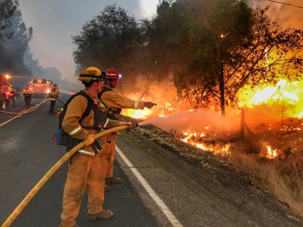
Image courtesy: Alameda County Fire Department
Get more local news delivered straight to your inbox. Sign up for free Patch newsletters and alerts.