Health & Fitness
Blast from the Past: So THAT's Where That Used to Be...
Is there anything Google CAN'T do?

A question that comes up a lot when discussing any historic structure or property that no longer exists is, “Where exactly did that used to be?”
Now, thanks to the magic of Google Earth and the good folks at the Contra Costa County Department of Conservation and Development, that question can be answered precisely. You can almost literally fly over any part of the county you want, and set the “way-back machine” to any year’s photos that are available. Be warned, though, you can start exploring the landscape, and the next thing you know, you look up and six hours have passed. This is THAT addicting.
Anyway, probably the coolest feature of Google Earth (and I’ve barely started exploring it) is you can overlay a map of the current streets onto the landscape.
Find out what's happening in Pinole-Herculesfor free with the latest updates from Patch.
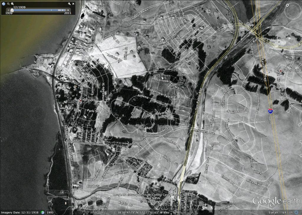
Take a look Figure 1. I know it may be a bit difficult to make out, especially on a web page. Downtown Pinole is at the very bottom of the page, just right of center. San Pablo Avenue should be very familiar, as it exists pretty much in the same state today. Just north and to the east of Pinole is what is now the Village Park development, and just east of that is Interstate 80. To the west of San Pablo Ave., you should be able to make out the streets of Olympian Hills (the old water tower is somewhere in there), and the familiar streets of Hercules by the Bay are just to the south. Just northeast of Olympian Hills is the Baywood neighborhood.
Figure 2 focuses in a bit closer to the old plant. Bottom center is Triangle Park (the big building I believe is the Community Center, now located in Pinole). Further west is the now Historic Homes neighborhood. Just to the north of Talley Way, right above what is now Promenade St, is White Columns. Continuing north on Santa Fe, between what is now Main Street and Sycamore Avenue, are the Clubhouse and Administration buildings, where they still stand.
Find out what's happening in Pinole-Herculesfor free with the latest updates from Patch.
Pretty much anything to the northwest of Sycamore is the former Powder Works plant.
Like I said, download Google Earth at your own risk. I’ve lost a good chunk of my Saturday to this. But if you’re a map geek like I am, you won’t be able to pull yourself away. Nothing has made our history more tangible to me than know EXACTLY where it happened.