Crime & Safety
Airport Fire Shows Signs Of Slowing Its Path Of Destruction
The massive blaze injured ten firefighters, two civilians and destroyed an unknown number of homes after it ignited in Orange County.


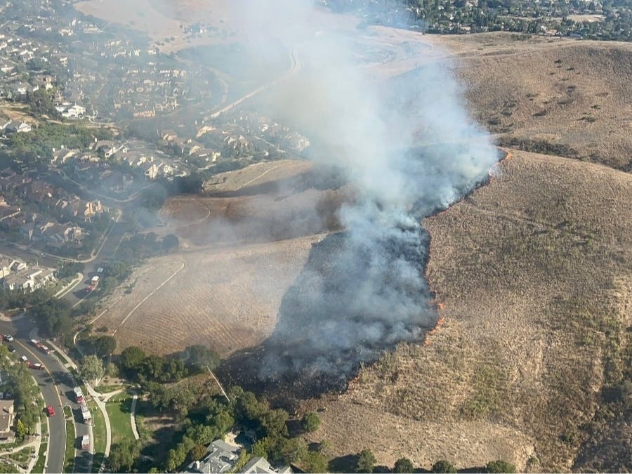
TRABUCO CANYON, CA —Aided by cooler weather, the spread of the destructive Airport Fire burning in Orange and Riverside counties has significantly slowed Thursday, and progress has been made on a blaze that has destroyed an unknown number of structures, injured 10 firefighters and two civilians and forced various school closures.
"Most of those firefighters injured were heat-related illnesses," Orange County Fire Authority Capt. Steve Concialdi said. "But one did get stung by numerous bees, and one sustained minor burns and the other couple had some injuries from fighting the fire, but all were released from the hospital and are doing well."
At a Wednesday afternoon news conference, OCFA Division Chief Kevin Fetterman reported two civilian injuries -- one who suffered a medical emergency and one with unspecified burns -- and a total of 10 firefighter injuries.
Find out what's happening in Rancho Santa Margaritafor free with the latest updates from Patch.
Cooler temperatures and denuded hillsides were aiding firefighters Wednesday, resulting in far less spread of the conflagration, Concialdi said.
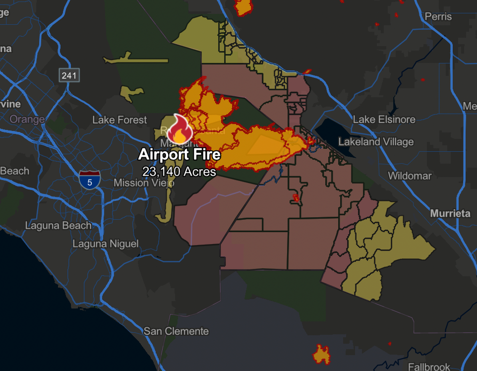
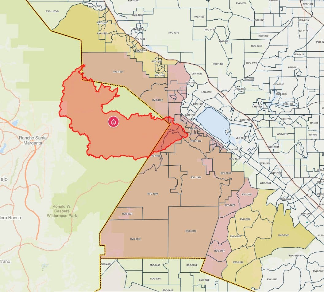
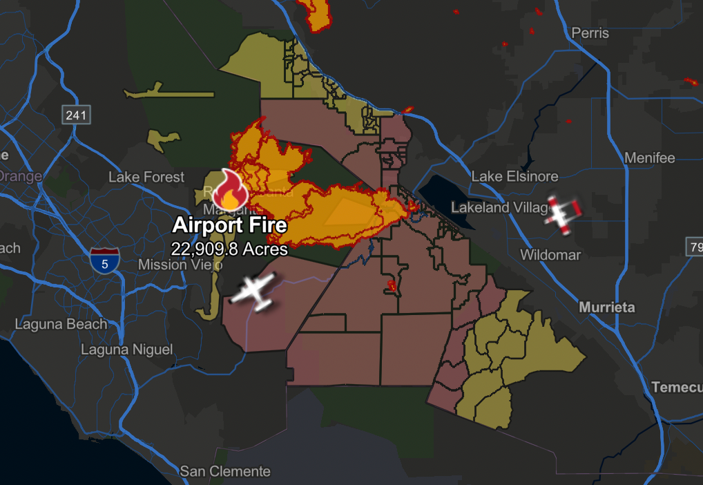
As of 7 p.m., Cal Fire reported that the fire was five percent contained, with 23,140 acres burned.
Find out what's happening in Rancho Santa Margaritafor free with the latest updates from Patch.
The blaze destroyed an unknown number of structures, injured 10 firefighters and two civilians and forced various school closures.
"We got a lot of recovery [Tuesday] night because it cooled down," Fetterman said. "Last night, it was 60 degrees, so that helped us improve those containment lines. That containment is expected to grow in our next report."
The agency's new firehawk helicopters also have "made a tremendous impact," he said.
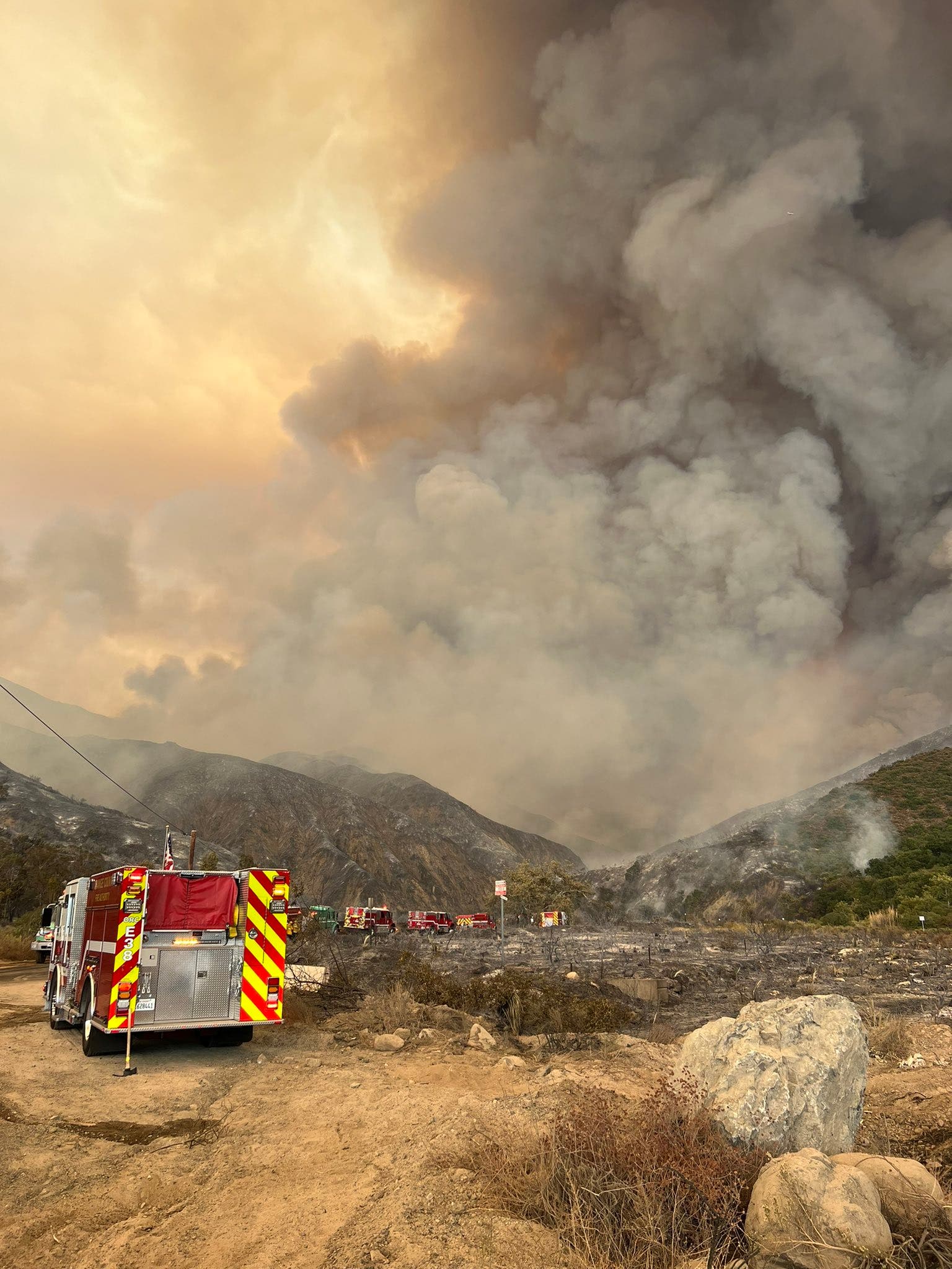
Orange County fire officials also reported that structures have been damaged or destroyed in the El Cariso, Long Canyon, Ortega Highway and CCC camp area. It was not immediately known how many buildings were consumed by the blaze.
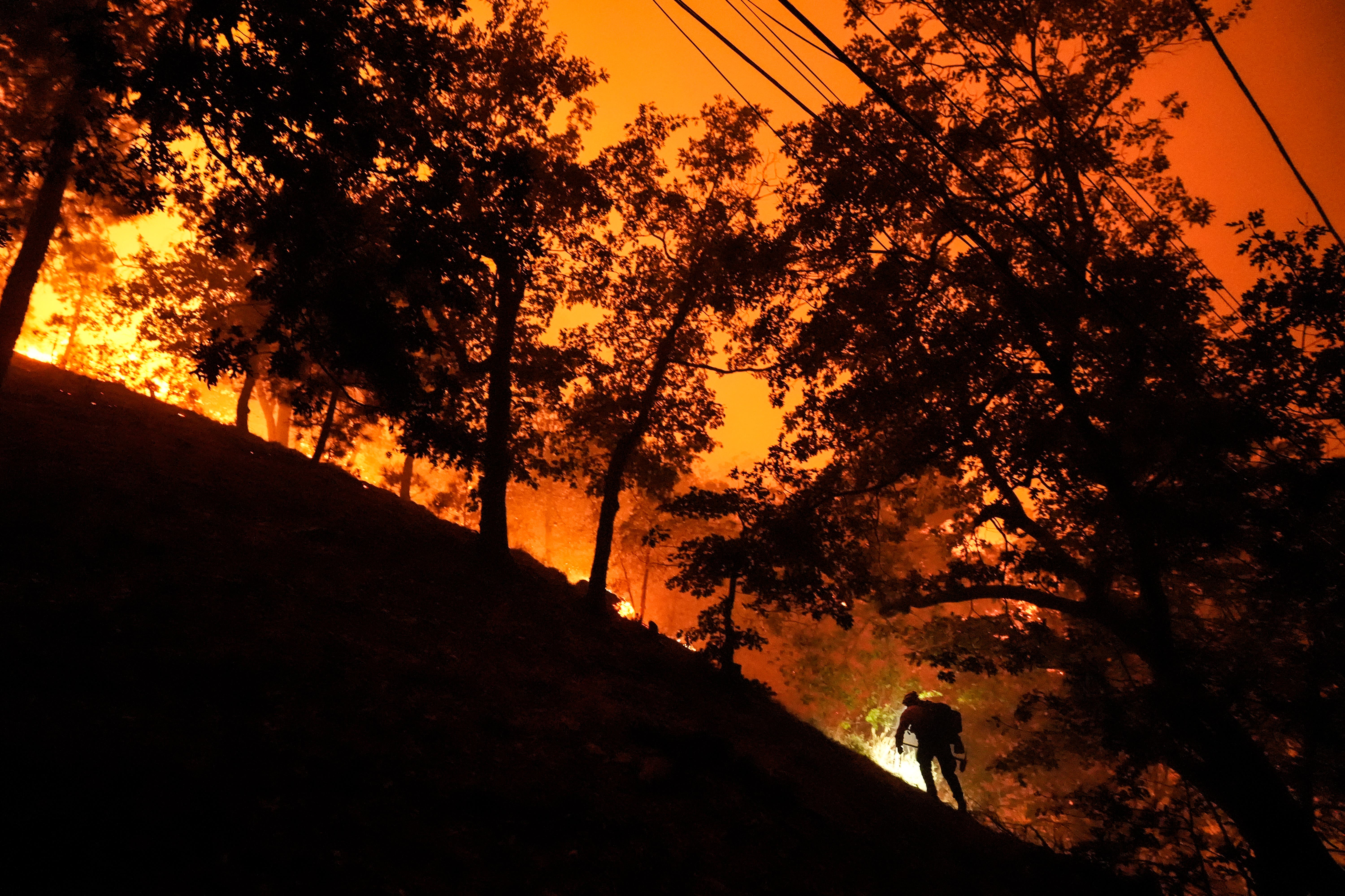
The brush fire that authorities said was unintentionally caused by county workers Monday afternoon continued to rage through the foothills Wednesday, jumping Ortega Highway to destroy multiple homes as it pressed from Orange County into Riverside County.
Thousands were forced to evacuate Tuesday as the growing blaze threatened their communities.
The wildfire burned through 22,372 acres with zero containment as of 3:30 p.m. Wednesday, according to the Orange County Fire Authority. The blaze was moving in the southeast direction toward Ortega Highway and deeper into Riverside County.
"Firefighters aggressively attacked from both air and ground. Heavy fire activity in the communities of the Ortega Highway has impacted structures," the OCFA wrote in a Facebook update. "Crews will continue to work on all three branches with the objective of perimeter control and structure protection."
Wednesday morning, Cal Fire announced new evacuation warnings for the following areas in Southwest Riverside County:
- South of White Sage St./Sugar Cane Ct.
- West of Interstate 15
- East of the Orange County/Riverside County line
- North of Maritri Rd./Santiago Cantou Rd./Mayhew Canyon Rd.
CalFire also upgraded evacuation warnings to evacuation orders in areas north of the Riverside County/San Diego County line, South of Lake Elsinore near the base of Ortega Highway, East of the Orange County/Riverside County line and West of South Main Divide Road/Grand Avenue.
New evacuation warnings were also issued for Silverado Canyon, Coto de Caza — East Side (Zones 1 & 2) and Modjeska Canyon Tuesday, according to the OCFA.
Residents can view an interactive map of evacuations by following this link.

Video by ABC7 showed several homes in the unincorporated Lake Elsinore area*, charred and burned to the ground Wednesday morning. In El Cariso, an unincorporated community near Lake Elsinore, photos showed firefighters battling intense flames amid homes eaten by flames.
It was not immediately known how many structures and homes were destroyed by the fire.
By Wednesday morning, Cal Fire reported that the fire had grown from 10,000 acres to 22,376 acres with no immediate word on containment.
"It has crested the north main divide and gone into Riverside County," Orange County Fire Concialdi said Tuesday.
On Tuesday, the blaze was boring down on Santiago Peak, which houses a series of radio and television broadcast towers used by local media as well as federal and local government agencies.
According to the OCFA, crews were working to protect the peak but had to withdraw from the area due to intense flames.
Tuesday night, the flames headed downslope toward Lake Elsinore, triggering countless evacuations.
"The fire continues to spread with the southeastern fronts showing the most growth. The fire made several significant runs at the Santiago Peak communications array this morning," Cal Fire said in a statement. "The fire has crossed Ortega Highway and is actively impinging upon structures in the area. As of this posting, it is unknown how many, or to what extent."
Over 626 firefighters were reported on the ground by Cal Fire, along with helicopters and airtankers. Additional fire resources were defending neighborhoods and communities, Cal Fire said Wednesday.
Mandatory evacuation orders for areas along Ortega Highway, near Caspers Park, remained in place Wednesday. The highway remained closed in both directions.
The blaze, which has zero containment, is burning through "dense vegetation," Concialdi said.
Talbot Hayes of the Cleveland National Forest said, "Three things are driving the fire right now and that's weather, fuel and topography."
Firefighters were battling areas with grass as high as four feet with chaparral as high as 8 feet, Hayes said. The terrain is at times "barely hikeable even for our most fit firefighters."
See the Riverside County evacuation updates here. For Orange County evacuation updates, click here. Also, Cal Fire has an online tool that lets residents and business owners quickly determine the evacuation status for their street address. Find the tool here.
A list of evacuation centers for humans and animals can be found here.
Related: Ortega Highway Closed In Both Directions Due To Airport Fire (note: find all road closures here)
City News Service contributed to this report.
* Correction: An earlier version of the story misstated where homes were destroyed. Homes in an unincorporated area of Lake Elsinore were destroyed by the fire.
Get more local news delivered straight to your inbox. Sign up for free Patch newsletters and alerts.