Weather
Cold Weekend Storm To Bring Rain And Snow To SoCal
After a few days of warmer weather, temperatures will drop along with rain and snow levels across Southern California.

SOUTHERN CALIFORNIA — Another wet weekend is in store for Southern California.
After a few days of warmer weather, much cooler weather is expected Friday through the weekend as another late-season storm moves into the region. The system is expected to bring rain, a chance of thunderstorms and mountain snow to the Southland, according to the National Weather Service.
While temperatures Wednesday and Thursday spiked 6 to 12 degrees above normal reaching 75 to 85 degrees across the Southland, daytime highs are expected to drop 10 degrees by Friday, according to the weather service. By the weekend, much of the Southland will be more than 10 degrees below normal.
Find out what's happening in San Diegofor free with the latest updates from Patch.
Temperatures will further drop to the low 60s by the weekend and even lower in the mountains, according to Rose Schoenfeld, a National Weather Service meteorologist in Oxnard.
"With this storm, we're going to see a drastic drop in temperatures first," Schoenfeld told Patch. "Today, we have a very above-normal day, warm, sunny and very summer-like. Then we're going to fall up to 10 degrees or so between today and tomorrow. Saturday and Sunday will be very cold for this time of year. We're looking at around 10-15 degrees below normal."
Find out what's happening in San Diegofor free with the latest updates from Patch.
Rain is expected to start falling along the Central Coast by Friday night, reaching Los Angeles County by Saturday morning or afternoon, according to the NWS. Showers could last until Sunday.
Total rain amounts are not expected to be high, Schoenfeld said. Los Angeles County totals are expected to measure around a quarter-of-an-inch to up to an inch of rain in the mountains.
Further south, chances of light showers will develop this weekend, with the first round expected on Saturday, and the second round on Sunday.
According to the NWS San Diego Office, rainfall totals for the weekend range from a few hundredths of an inch up to a quarter-of-an-inch of rain across the coast and valleys. In the deserts, generally, less than a tenth-of-an-inch of rain is anticipated. A tenth-of-an-inch to a half-inch of rain is forecast for the mountains, with isolated higher amounts in San Bernardino County.
Gusty winds are expected over the mountains and deserts, peaking Saturday afternoon and evening with gusts up to 40-55 mph, according to the NWS. A second, weaker round will occur Sunday afternoon and evening.
There will also be a 10-20 percent chance of isolated thunderstorms.
"It's a pretty medium storm," Schoenfeld said.
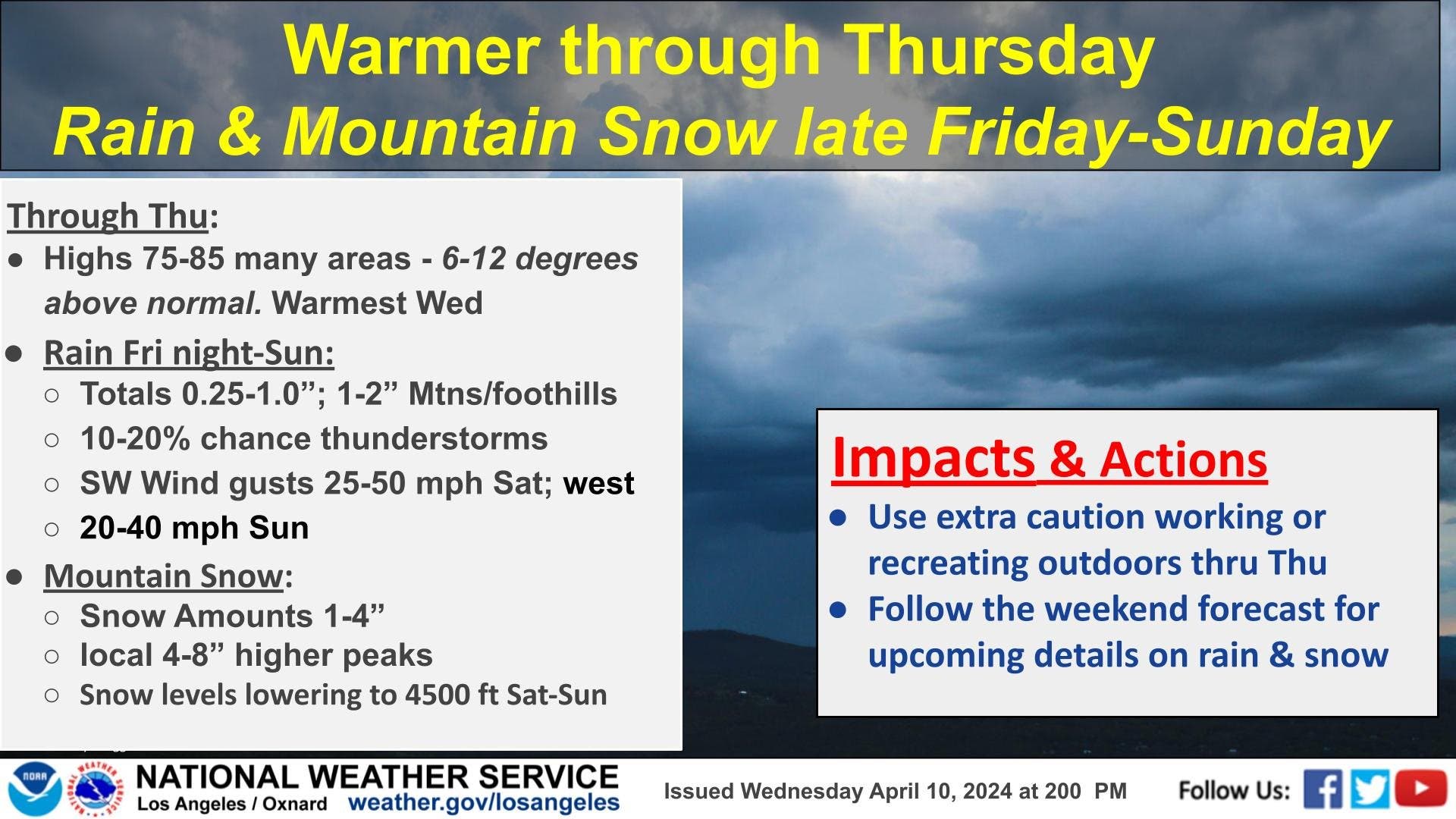
The storm will also bring snow to the Los Angeles County mountains. Snow levels will initially fall to about 6,000 feet, with several inches of snow possible on higher peaks, according to the NWS. By Sunday morning, snow levels will drop to about 3,500 feet in elevation. Light snow is possible over the Grapevine stretch of Interstate 5.
Further south, snow levels look to remain around 5,500 to 6,500 feet for the first round on Saturday before falling as low as 4,500 to 5,500 feet on Sunday.
Unsettled weather returning this weekend (sorry to be the bearer of bad news 🫤). Gusty winds are expected over the mtns into the deserts Fri through the weekend. West of the mtns periods of showers can be expected, most likely during the day Sat with scattered showers on Sun. pic.twitter.com/D4Xvz3iENw
— NWS San Diego (@NWSSanDiego) April 10, 2024
After this storm, long-range forecasts predict a drier rest of the month. The six- to-10 day and eight- to 14-day outlooks are both trending toward below-average rainfall, according to the National Weather Service's Climate Prediction Center.
"Nothing is evident on the horizon to us, but it's not impossible," Schoenfeld said.
Get more local news delivered straight to your inbox. Sign up for free Patch newsletters and alerts.