Weather
'Major Winter Storm' To Bring More Rain, Mountain Snow To SoCal
The notably cold storm system will bring rain, gusty winds and mountain snow to Southern California.


SOUTHERN CALIFORNIA — Another powerful storm system is moving toward California.
Although the majority of rain from the cold winter storm will fall in Northern California, which is expected to get 12 feet of snow on the Sierra Nevada mountains, the system will bring rain, gusty winds and mountain snow this weekend to Southern California, according to the National Weather Service.
The storm is expected to bring blustery conditions to the region with temperatures as much as 15 degrees below normal, low snow levels and powerful wind gusts from the coast to the mountains and deserts. Unlike the recent atmospheric river storms, this cold storm is unlikely to bring intense downpours to the region. However, with already saturated hillsides, the storm poses mudslide threats to some areas.
Find out what's happening in San Diegofor free with the latest updates from Patch.
"We do have another storm on the way for the end of the week, but each projection has been trending weaker," said National Weather Service Meteorologist Ryan Kittell. "We're not really expecting a lot of rain with this storm, though it will likely result in a pretty prolonged period of fairly steady light rain."
Travel over the Sierra will be nearly impossible Thursday-this weekend as a major winter storm approaches. Be sure to follow @NWSSacramento, @NWSReno, and @NWSHanford for more updates on upcoming winter weather conditions over the mtns. Stay safe! #CAwx https://t.co/oloFwGU0bk
— NWS Bay Area 🌉 (@NWSBayArea) February 27, 2024
The storm could bring light rain or drizzle to the area as early as Thursday night, with more widespread rain expected Friday morning through Sunday afternoon, Kittell told Patch Tuesday afternoon.
Find out what's happening in San Diegofor free with the latest updates from Patch.
This storm system will be colder than recent storms with heavier rainfall. There won't be as much moisture, Kittell said, so there will be less rainfall when the storm hits the region.
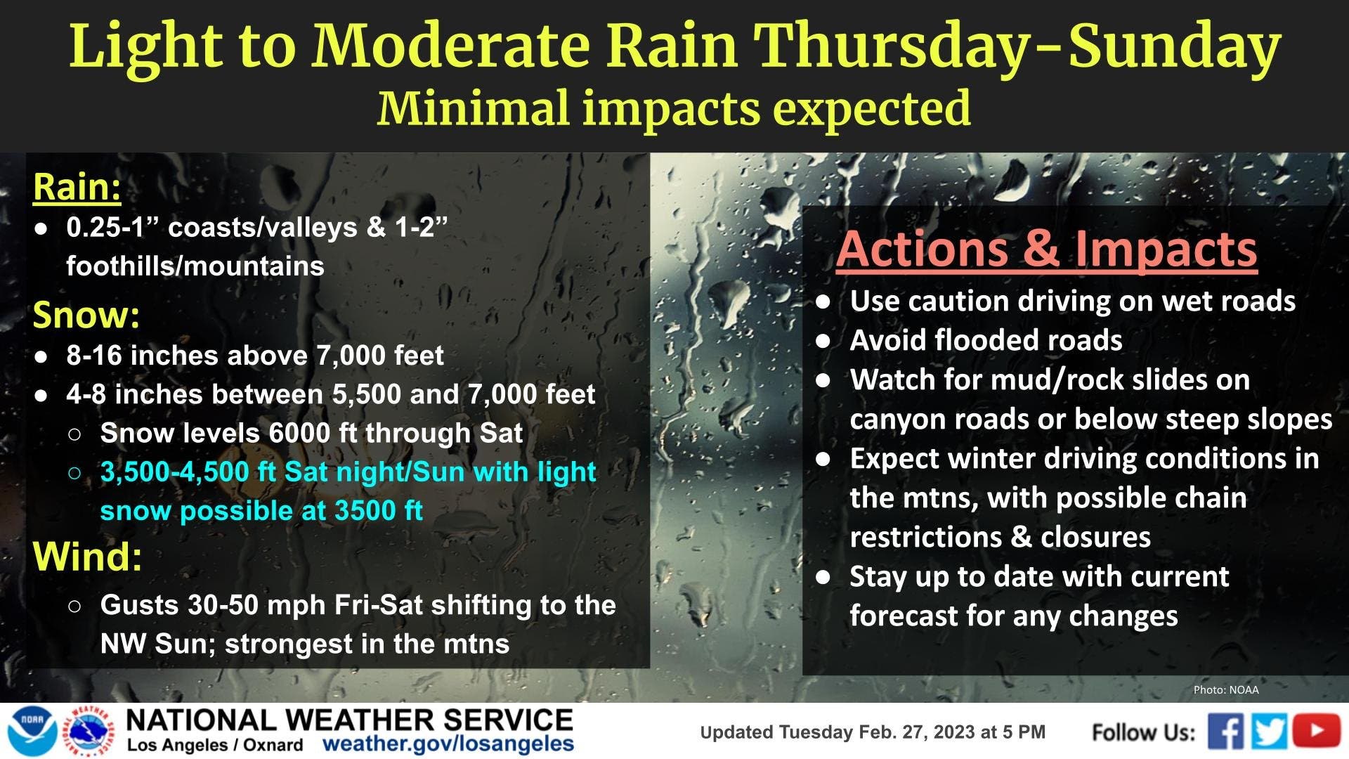
A quarter of an inch to an inch of rain is expected in the coastal areas and valleys, while the foothills and mountains could get between 1 to 2 inches of rain, according to the weather service.
"Those totals are spread out over a fairly long period, so the intensity is fairly low," Kittell said.
There is still uncertainty in the forecast, especially with rainfall estimates and timing, for when the storm moves south.
"This system is interesting because it looks like it's going to move inland, probably across the Pacific Northwest," said National Weather Service meteorologist Elizabeth Adams.
"The track of the actual system is really going to have a big impact on how much rain is going to fall," Adams told Patch Tuesday afternoon. "It looks like a lot of the moisture is really going to be missing us to the north. They're expecting really, really heavy snowfall across the Sierra Nevada and heavy rain in Northern California. By the time it gets down here, it looks like a lot of the moisture is going to get wrung out."
The atmosphere over the Gulf of Alaska looks like it's in a silly mood 😉 It's no laughing matter though, this low will eventually move south and inland across CA, bringing rain, heavy snow in the Sierra, and strong winds to much of the central and northern parts of the state. pic.twitter.com/Hki539ysjs
— NWS San Diego (@NWSSanDiego) February 28, 2024
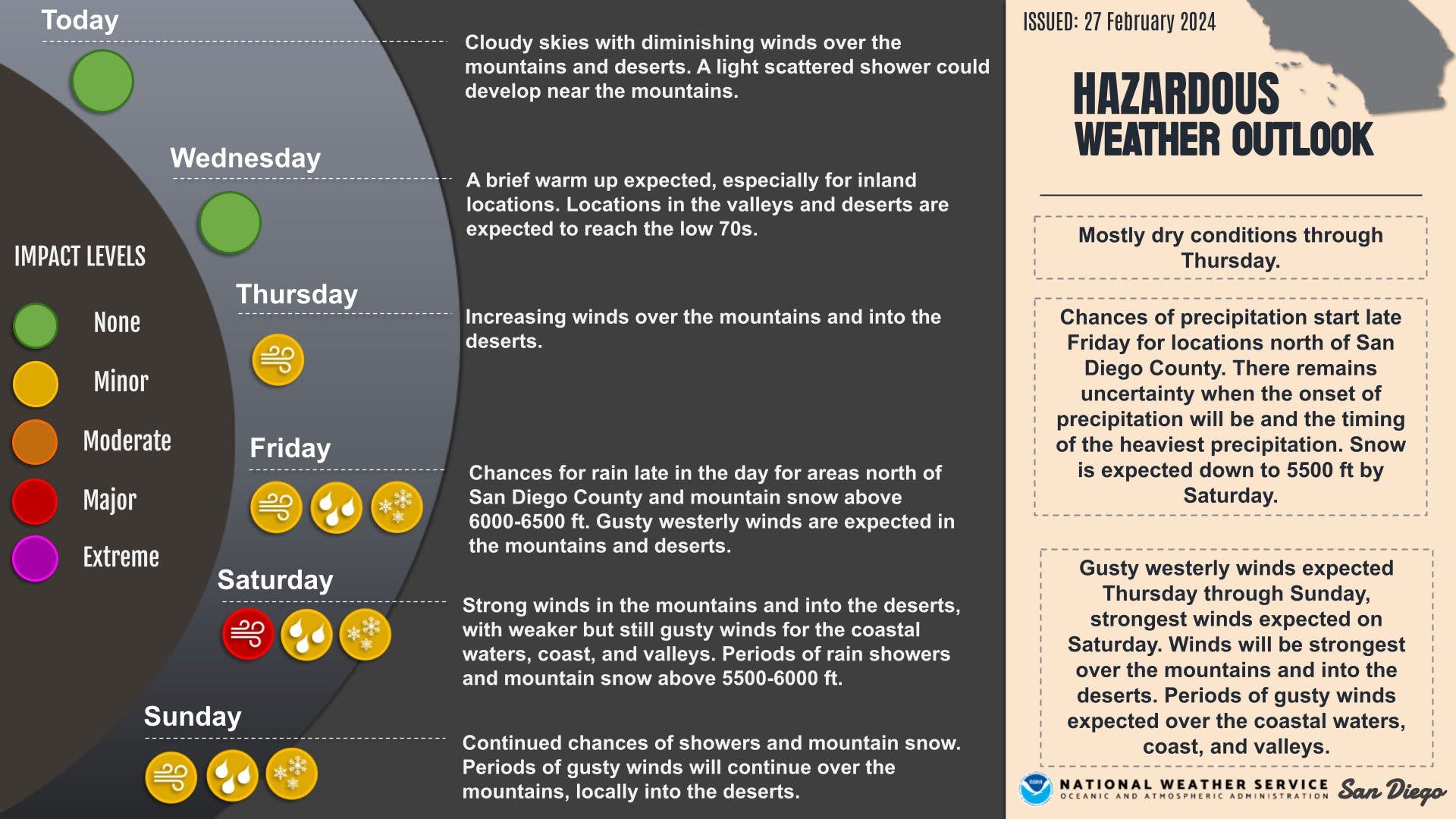
Chances of rain are expected to start late Friday for areas north of San Diego County, including the Inland Empire and Orange County, Adams said. The storm system will likely reach the San Diego region Saturday morning.
"It looks like the brunt of it is really going to fall through the daylight hours on Saturday," Adams said. "Rain chances are going to diminish from north to south Sunday morning."
As of Tuesday afternoon, a few tenths of an inch of rain is expected for the coastal areas and valleys of Orange and San Diego counties, Adams said. Rain is expected to be heavier in the mountains, which could receive between a half-inch to an inch-and-a-half of rain. The deserts could get a trace, up to about a tenth of an inch of rain.
"What we're most uncertain on in the forecast right now is how much rain is actually going to fall," Adams said. "We don't know how much moisture is really going to make it down here."
Although this storm is only expected to bring light to moderate rain to Southern California, forecasters still advised residents to use caution when driving on wet roads, avoid flooded roads, and watch out for mudslides or rockslides on canyon roads or below steep slopes.
"The ground is pretty saturated still," Adams said.
The storm is also expected to bring gusty winds to parts of the region.
"The bigger threat of this system for us is actually going to be wind," Adams said. "It's going to be pretty breezy, even including coastal areas."
Gusty westerly winds are expected Thursday through Sunday, with the strongest winds expected Saturday, according to the NWS San Diego Office.
Winds will be strongest over the mountains and into the deserts. Periods of gusty winds are also expected over the coastal waters, coast and valleys.
Wind gusts from 30 to 40 mph are possible in the coastal areas and valleys, Adams said. Stronger winds are expected in the mountains where wind gusts are expected to reach at least 50 mph and could reach as high as 70 to 80 mph. Wind gusts from 40 to 50 mph are possible in the deserts.
Further north, wind gusts could reach from 30 to 50 mph Friday through Saturday, with the strongest winds expected in the mountains, according to the NWS Los Angeles/Oxnard Office.
Wind gusts will peak from 25 to 35 mph in the urban areas, Kittell said.
Kittell noted that the "most significant thing" about this storm is that it is colder that the most recent storms.
The snow levels will start around 6,000 feet Friday and then steadily lower to 3,500 to 4,500 feet by Sunday morning, according to the NWS Los Angeles/Oxnard Office. Forecasters expect 8 to 16 inches of snow above 7,000 feet and 4 to 8 inches of snow between 5,000 and 7,000 feet.
"While we don't expect a lot of snow because the precipitation isn't going to be very high, some lower elevations have a risk of accumulating snows," Kittell said. "That means more impacts to mountain roads, which would include the Cajon Pass/Grapevine area on Interstate 5."
Further south, snow is expected down to 5,500 feet by Saturday, according to the NWS San Diego Office. Snow levels could fall as low as 3,500 feet late Saturday night into Sunday morning, Adams said.
"It's actually going to be a pretty cold system," Adams said. "Highs are generally going to be running about 10 to 15 degrees below normal. Combining passing rain showers, strong winds and cold high temperatures, it's going to feel pretty chilly this weekend."
Drier and warmer — yet still cool — weather is expected Monday and Tuesday. High temperatures on Tuesday are predicted to be a few degrees below average near the coast and between 5 to 10 degrees below average for the mountains.
Get more local news delivered straight to your inbox. Sign up for free Patch newsletters and alerts.