Health & Fitness
Visualizing North Bay Transit
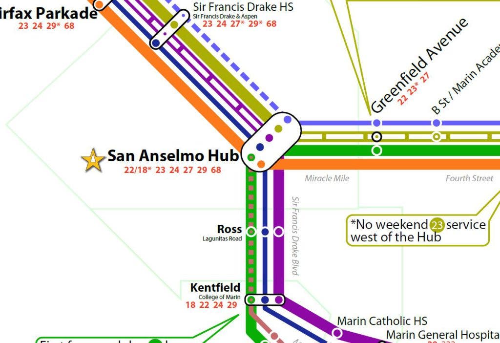
A custom-designed bus map for Ross Valley brings clarity to our transit system's complicated map.
The greatest problem with bus lines is that nobody knows where they go. While light rail or streetcar tracks are not for every route, they do let people visually understand where transit goes. Buses, however, travel along the same roadways as cars, leaving potential riders in the dark as to where they go. Communicating a route properly is extremely important to pulling back the veil of our transit system, and for showing people how transit is freedom from the car.
To address this problem in at least one corner of Marin, I’ve designed a draft spider map for the San Anselmo Hub (PDF). We . In short, they are schematics of where buses intersecting a certain point run. Such diagrams are used most successfully in London where they integrate with Tube stations, although Washington, D.C., has made some forays into this field of late by putting bus line schematics at bus stops and huge Transit Information Displays, or TIDs, in their metro stations. (If anyone can find me a PDF of those TIDs, I’ll be forever grateful.) The point is to simplify a bus map by pulling out any unnecessary clutter and isolating just the bus routes, showing where riders can go without transferring. It is, at least to some degree, a map of the freedom available to you from a given point.
My Hub spider map don’t show all the stops, as those can change. Rather, the map shows primary stops that are unlikely to change, such as . The route lines and stop circles are displayed differently depending on levels of service to give riders a clear visual of where they can always go and where they may need to check a schedule.
Find out what's happening in San Rafaelfor free with the latest updates from Patch.
As people generally don’t care what service they use to go from point A to B, I included all possible transfers, along with the logos of other agencies, wherever necessary. This is best seen at the San Rafael Transit Center, which has transfers to all over the North Bay. Transfers in San Francisco, such as connections to the Cable Car, may be valuable to families that want to spend a weekday as tourists in the city. Including such data also helps riders start to build a mental map of transit beyond Marin, adding connection points to knit them all together. Plus, it provides advertising for the other agencies. I had never bothered to take the bus to the Oakland Airport, but now I know I can. If I want to take a bus to the city of Sonoma, I know I can take the 38S, even if I don’t know when. The regional transit network map is intended to be an aid in that process.
Giving people a destination-based frequency guide shows riders how they could go from A to B. If I’m in San Anselmo and I want to get to San Rafael, I don’t care if I take the 23 or the 22. The two lines complement one another along that corridor, and the frequency table reflects that. Given space restrictions I did not include a full-fledged timetable, but I’m assuming other signage is nearby. Timetables will still be necessary, as this map is for outbound trips only; the 22 doesn’t always leave from Sausalito and once per weekday winds through Mill Valley on its way north, but never does going south. These inbound trips are not visualized, and could confuse travelers.
Find out what's happening in San Rafaelfor free with the latest updates from Patch.
The rest of the design is taken from MTC’s TIDs (PDF of AC Transit's TIDs), which are sadly missing in Marin. The orange i logo, the headers, the green were added to visually identify this map with those more common maps. A San Franciscan visiting San Anselmo would instantly recognize the visual vocabulary, knitting together in their mind that the Hub is still part of the regional transit network even if MUNI doesn’t run buses there, and a San Anselman would feel a similar sense of recognition when leaving the county.
I chose to map the Hub mostly because I know San Anselmo best, but also because of the location’s flexibility. With some modifications it could be adapted for use up and down Ross Valley. Used in conjunction with broader system maps and timetables, it would be a powerful tool for Marinites.
Since it’s a draft, I’d appreciate any comments and criticisms. You should know that I added a small border around the map, which is why things look a bit more squished inward than they otherwise ought. I'll post a final copy when it's done, which you should feel free to print (and laminate!) and put it at the Hub. I designed it on tabloid-sized paper, less than half the size of a traditional TID, so you can print it out without much hassle, though I'm sure print shops would be happy to print it double-sized.
What do you think? What TIDs and maps should come standard at any Marin transit hub?