Crime & Safety
More Of Santa Monica Is Now In A 'Very High' Fire Hazard Zone
For the first time in over a decade, the state has released updated maps showing wildfire hazards in local neighborhoods.

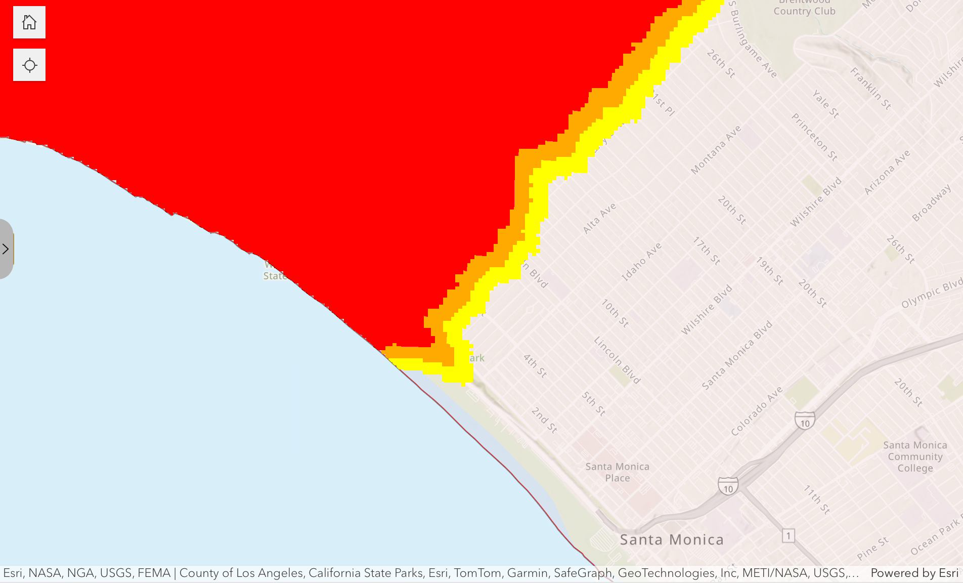
SANTA MONICA, CA — The number of Santa Monica homes and businesses within "very high" fire hazard zones has increased, according to new maps released by Cal Fire this week.
The agency released updated Fire Hazard Severity Zone maps for Los Angeles County on Monday, which use various criteria — including terrain, fire history, weather patterns and the presence of fire fuels — to identify wildfire hazard areas and rank them in three categories: "moderate," "high" and "very high."
The maps, generally updated every decade, can impact building and clearance requirements in areas deemed to be in particular hazard areas.
Find out what's happening in Santa Monicafor free with the latest updates from Patch.
The new maps for Santa Monica show an increase in the size of hazard areas in the northern limits of the city, compared to the last set of maps released between 2007 and 2011.
Cal Fire determines the level of hazard based "on the physical conditions that create a likelihood and expected fire behavior over a 30- to 50-year period, without considering mitigation measures such as home hardening, recent wildfire or fuel reduction efforts."
Find out what's happening in Santa Monicafor free with the latest updates from Patch.
Now that the hazard zone maps have been released by the state, local jurisdictions can adopt them or amend them by increasing the hazard level for particular areas. Jurisdictions cannot reduce the hazard levels from those recommended by state officials.
The Los Angeles County Fire Department said it is not recommending any additions or increases. The agency noted that the updated maps likely mean an increase in the number of local parcels falling within hazard zones.
"These changes may influence building and vegetation management requirements for properties located within newly classified fire hazard zones," the department said.
The Los Angeles County Board of Supervisors must act within 120 days to adopt the maps, which are used to guide land-use decisions and building standards. The county is expected to schedule public hearings for people to comment on the proposed maps, but specific dates have not yet been determined.
More information, including the fire zone maps, is available on Cal Fire's website.
City News Service contributed to this report.
Get more local news delivered straight to your inbox. Sign up for free Patch newsletters and alerts.