Crime & Safety
Evacuation Warning For A Fast Moving Fire On Los Alamos Road In Sonoma County
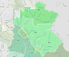
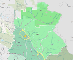
This area is referenced as zones 6A1, 6B1 and 6B2 in the attached map.

September 27, 2020
There are multiple fires on Los Alamos Road. This is an Evacuation WARNING for the following areas:
Find out what's happening in Sonoma Valleyfor free with the latest updates from Patch.
Zone 6A1:
Southwest of Highway 12
Find out what's happening in Sonoma Valleyfor free with the latest updates from Patch.
East of Santa Rosa City Limits, the eastern boundary of Annadel State Park, and Savannah Trail
North of Bennett Valley Road
West of Warm Springs Road
Zone 6B1:
South and west of the Napa/Sonoma County Line
Northeast of Highway 12 and north of the southernmost boundary of Sugarloaf Ridge State Park
Northwest of Adobe Canyon Road
East of Pythian Road and Hood Mountain Regional Park
Zone 6B2:
Northeast of Highway 12
Northwest of Nelligan Road/Nuns Canyon Road
West of the Napa/Sonoma County line
Southeast of Adobe Canyon Road and south of Sugarloaf Ridge State Park
Go to socoemergency.org or call 2-1-1 if you have any questions. View the interactive evacuation map and search your address at https://arcg.is/0buuL1. If you need help evacuating animals, call 707-861-0699 (Sonoma CART). If you need help evacuating livestock, call 707-234-7193 (NorCal Livestock Evac).
This area is referenced as zones 6A1, 6B1 and 6B2 in the attached map. Future orders will reference this map as well.
If you feel unsafe, evacuate.
This press release was produced by the Sonoma County Sheriff's Office. The views expressed here are the author’s own.