Weather
Hurricane Florence: Latest Forecast Good News For Connecticut
The storm could still have some leftover impact to Connecticut.

A hurricane churning hundreds of miles off the East Coast is now increasingly likely to hit land, but it appears Connecticut will be spared from the brunt of the storm. Still, it is too early to determine the storm's exact path.
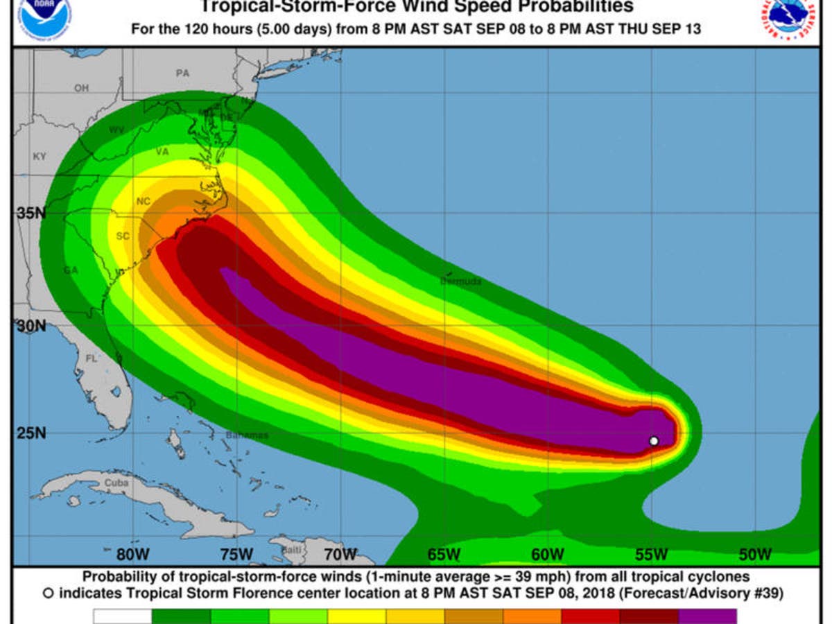
The National Hurricane Center warned people from South Carolina into the mid-Atlantic region to watch the storm's progress closely and prepare for a potential impact.
The center's latest projections late Sunday morning say the hurricane's track puts it as far north as New Jersey, with an estimated landfall of Thursday night. However, the odds of even New Jersey seeing sustained strong winds from the storm are below 20 percent.
Find out what's happening in Across Connecticutfor free with the latest updates from Patch.
"The risk for impacts along the East Coast has increased," according to the National Weather Service.
WTNH Meteorologist Gil Simmons predicts that Connecticut could get some leftover heavy rain early next week.
Find out what's happening in Across Connecticutfor free with the latest updates from Patch.
Hurricane Florence's winds continue to sir the Atlantic east of Bermuda, according to the National Hurricane Center. It's moving northwest at 12 mph and is expected to retain its status as a hurricane for several days.
Meteorologists said there is a very real chance the Northeastern US, from North Carolina to New England, will be affected. On Sunday, forecasters remained committed to that prediction.
The latest track from the National Hurricane Center brings Florence into the western Atlantic by Wednesday, according to the National Weather Service. At that point, there is still uncertainty with the eventual track of Florence.
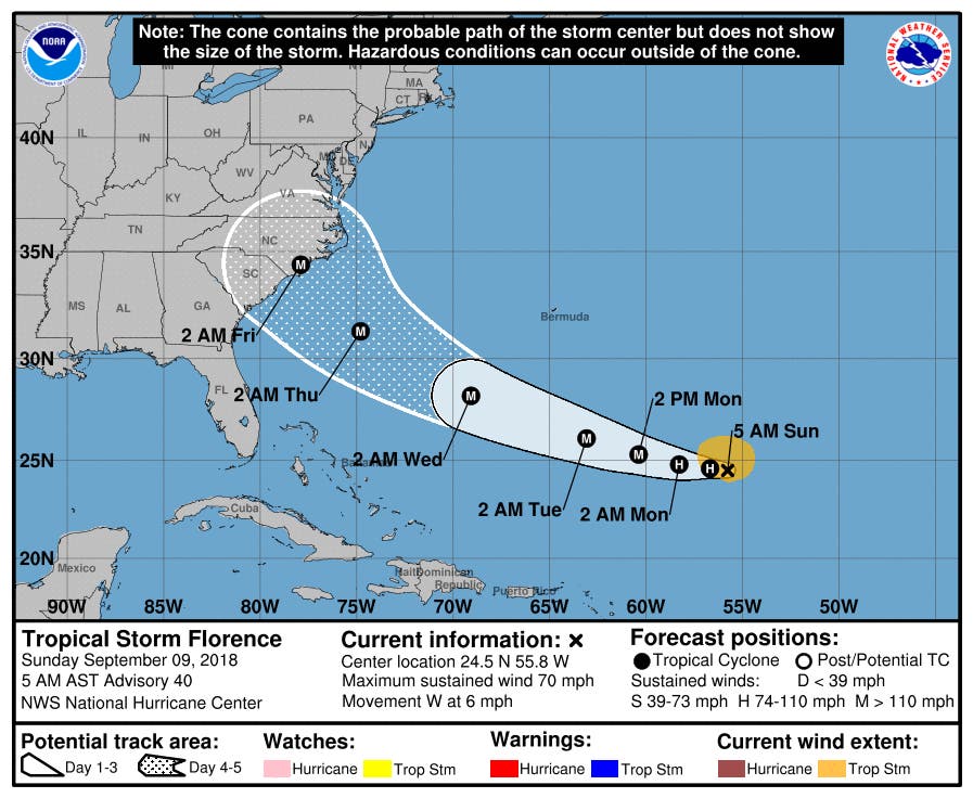
The storm was expected to weaken a little as it passed through a jet stream before restrengthening.
Connecticut can expect some wet weather this coming week.
Below is the forecast for southern Connecticut:
Tonight
Rain, mainly after 11pm. Low around 58. East wind 15 to 17 mph. Chance of precipitation is 80%. New precipitation amounts between a quarter and half of an inch possible.
Monday
Periods of rain. High near 73. Breezy, with an east wind 18 to 20 mph. Chance of precipitation is 80%. New precipitation amounts between three quarters and one inch possible.
Monday Night
Showers and thunderstorms likely. Cloudy, with a low around 73. Southeast wind 8 to 18 mph. Chance of precipitation is 70%. New rainfall amounts between a half and three quarters of an inch possible.
Tuesday
A 50 percent chance of showers and thunderstorms. Mostly cloudy, with a high near 84. Southwest wind 8 to 11 mph.
Tuesday Night
Mostly cloudy, with a low around 70.
Wednesday
A 30 percent chance of showers and thunderstorms. Mostly cloudy, with a high near 85.
Northern Connecticut forecast
Tonight
A chance of showers, mainly after 4am. Cloudy, with a low around 55. Northeast wind around 9 mph. Chance of precipitation is 30%. New precipitation amounts of less than a tenth of an inch possible.
Monday
Showers, with thunderstorms also possible after 2pm. Some of the storms could produce heavy rain. High near 67. East wind around 10 mph, with gusts as high as 20 mph. Chance of precipitation is 90%. New rainfall amounts between a half and three quarters of an inch possible.
Monday Night
Showers and possibly a thunderstorm, mainly before 5am, then a chance of showers and thunderstorms after 5am. Some of the storms could produce heavy rain. Patchy fog. Low around 65. Southeast wind 6 to 9 mph, with gusts as high as 20 mph. Chance of precipitation is 80%. New rainfall amounts between a half and three quarters of an inch possible.
Tuesday
Showers and thunderstorms likely, mainly after 7am. Cloudy, with a high near 81. South wind around 6 mph. Chance of precipitation is 70%.
Tuesday Night
A chance of showers and thunderstorms, mainly before 11pm. Mostly cloudy, with a low around 67. Chance of precipitation is 40%.
Wednesday
A chance of showers and thunderstorms after 8am. Mostly cloudy, with a high near 81. Chance of precipitation is 40%.
With reporting by Adam Nichols'
Lead image by the National Hurricane Center
Get more local news delivered straight to your inbox. Sign up for free Patch newsletters and alerts.