Weather
Nor'easter Impacts On CT: Here's Everything We Can Expect From This Storm
Find out the latest storm track and what it means for your weekend, according to meteorologists.

A powerful nor’easter hitting the east coast this weekend will have minor impacts here in Connecticut, with only a small amount of snow expected in the southeastern corner of the state, according to meteorologists.
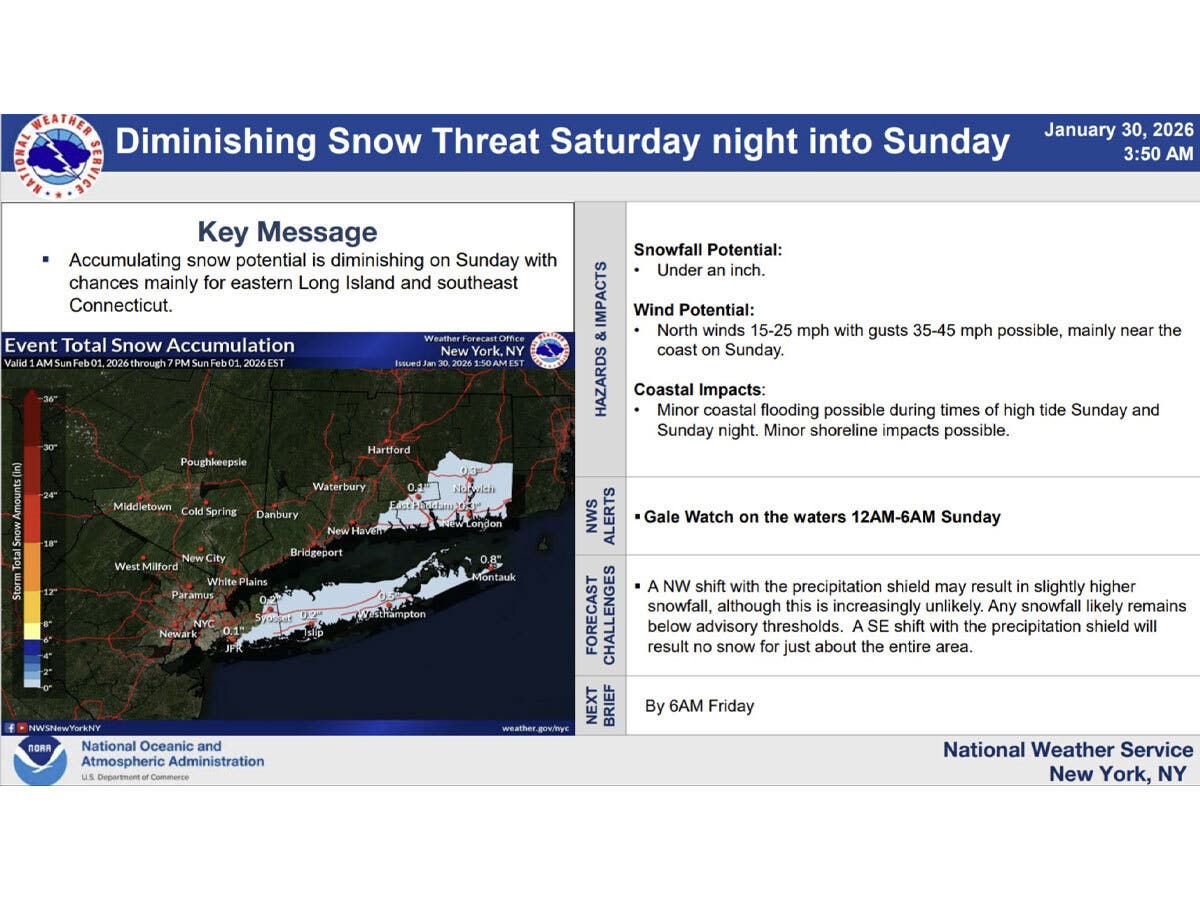
The National Weather Service in New York on Friday morning reported the snow potential for Sunday is diminishing.
“Most of the area will see no snow accumulation with the highest chance residing across eastern Long Island and southeast Connecticut,” the National Weather Service said. “However, amounts will be under an inch.”
Find out what's happening in Across Connecticutfor free with the latest updates from Patch.
Strong winds remain possible near the coast on Sunday, with gusts of up to 45 miles per hour, according to the National Weather Service. There could also be minor coastal flooding around high tide Sunday. There is a gale watch on the water for midnight to 6 a.m. on Sunday.
“A (northwest) shift with the precipitation shield may result in slightly higher snowfall, although this is increasingly unlikely,” the National Weather Service said. “Any snowfall likely remains below advisory thresholds. A (southeast) shift with the precipitation shield will result in no snow for just about the entire area.”
Find out what's happening in Across Connecticutfor free with the latest updates from Patch.
WFSB’s meteorologists are reporting Friday that the models continue to show the storm moving to the east, away from Connecticut.
“We’re not expecting snow this time around, although with that said, there could be some flakes in NE/SE CT,” WFSB reports. “We expect the intensity of the wind to increase Sunday, into Sunday night. Gusts between 30 and 40 mph will be likely.”
According to WFSB, a shift further east would mean a complete miss for Connecticut on Sunday, while a westward shift could mean a bigger impact here.
WTNH is calling the storm “a miss” for Connecticut, with just clouds and flurries on Sunday. It also predicts it will be cold and windy Sunday, with gusts up to 40 miles per hour and high tide coastal flooding.
If you have plans to travel south this weekend, closely monitor the weather. While the nor’easter isn’t expected to have much impact here in Connecticut, it is expected to be a major winter storm in the Carolinas and southern Virginia, according to the National Weather Service.
Read More:
- $1M Worth Of Property Stolen In Home Burglaries: Police
- Parent Outcry Results In Cancellation Of Education Secretary Linda McMahon's Visit To Local School
- Man Rescued From Icy Waters, Taken To Hospital: Police
Here are the forecast details for southern Connecticut via the National Weather Service:
Today: Sunny and cold, with a high near 20. Wind chill values between -5 and 5. West wind 11 to 15 mph.
Tonight: Mostly clear, with a low around 3. Wind chill values between -5 and zero. Northwest wind 5 to 8 mph.
Saturday: Mostly sunny, with a high near 23. Wind chill values between -5 and 5. Northwest wind 5 to 7 mph.
Saturday Night: Increasing clouds, with a low around 9. Wind chill values between -5 and 5. North wind 7 to 13 mph, with gusts as high as 23 mph.
Sunday: A 30 percent chance of snow. Mostly cloudy, with a high near 25. North wind 15 to 17 mph, with gusts as high as 29 mph.
Sunday Night: Partly cloudy, with a low around 15.
Monday: Sunny, with a high near 31.
Here are the forecast details for northern Connecticut via the National Weather Service:
Today: Sunny, with a high near 14. Wind chill values as low as -13. Northwest wind 7 to 13 mph, with gusts as high as 24 mph.
Tonight: Mostly clear, with a low around -7. West wind 5 to 7 mph becoming calm after midnight.
Saturday: Sunny, with a high near 19. Wind chill values as low as -7. Calm wind becoming north around 5 mph in the afternoon.
Saturday Night: Mostly cloudy, with a low around 4. Wind chill values as low as -11. North wind 5 to 10 mph, with gusts as high as 21 mph.
Sunday: Mostly cloudy, with a high near 24. North wind 13 to 15 mph, with gusts as high as 28 mph.
Sunday Night: Mostly cloudy, with a low around 7. Northwest wind 10 to 14 mph, with gusts as high as 26 mph.
Monday: Mostly sunny, with a high near 30. Northwest wind around 10 mph, with gusts as high as 20 mph.
Get more local news delivered straight to your inbox. Sign up for free Patch newsletters and alerts.