Weather
Tornado Watch Issued For 3 Counties In Connecticut
A hazardous weather outlook is in effect for portions of Connecticut.

UPDATE: A tornado watch has been issued for Hartford, Tolland and Windham counties until 7 p.m., according to the National Weather Service.
Gov. Ned Lamont said on X, "Stay alert today as a Tornado Watch has been issued for parts of Connecticut until 7PM."
"As always during any weather event, it’s a good idea to keep your mobile devices plugged in and fully charged in case of an outage," Lamont wrote.
Find out what's happening in Across Connecticutfor free with the latest updates from Patch.
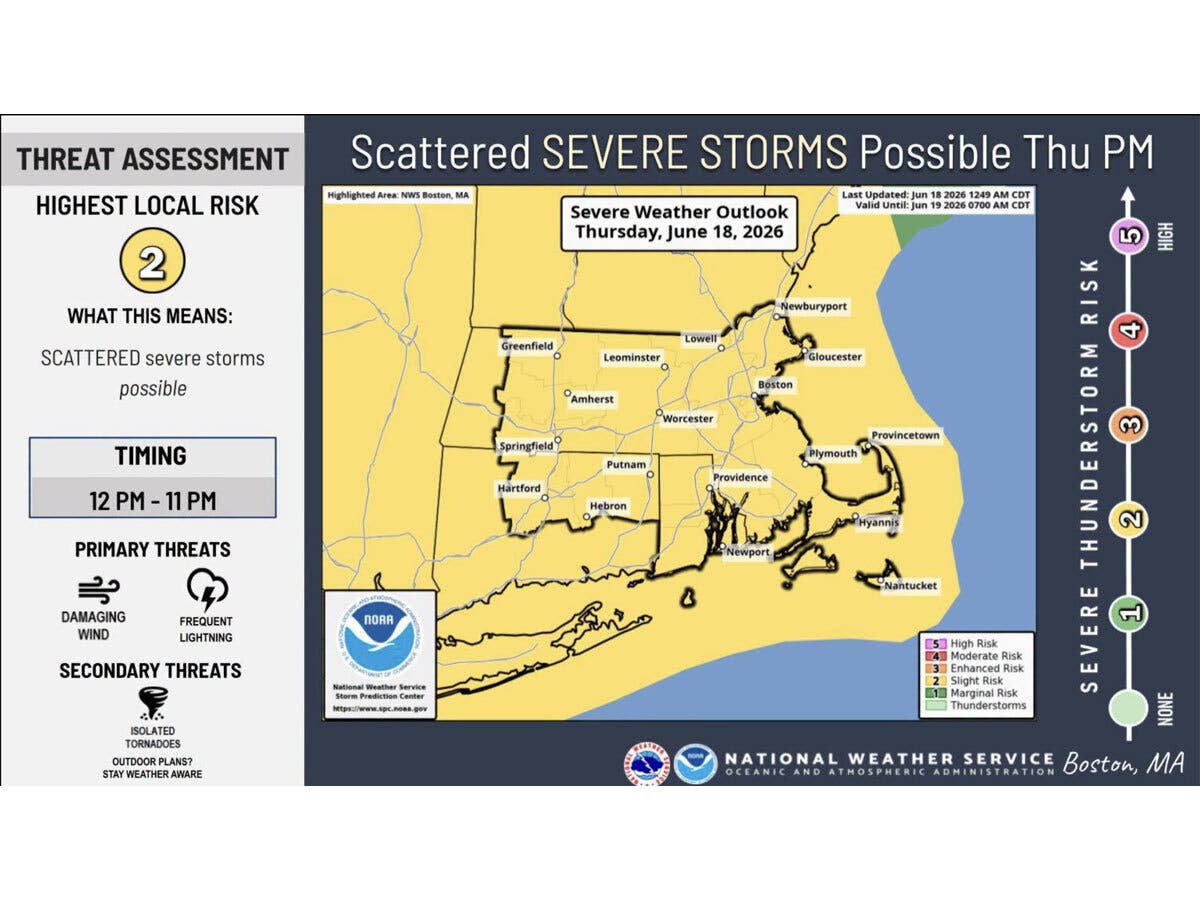
Scattered severe thunderstorms are possible this afternoon, with damaging wind and frequent lightning the primary threats, according to the National Weather Service.
It predicts the likeliest timeframe for storms will be between noon and 11 p.m.
Find out what's happening in Across Connecticutfor free with the latest updates from Patch.
“A warm front lifting through our region brings a period of humid and unsettled weather today,” the National Weather Service said.
Its forecast includes a chance of “strong to severe thunderstorms” this afternoon and evening.
“The strength and coverage of severe weather depends on the amount of clearing this afternoon,” the National Weather Service said.
It issued a hazardous weather outlook for southern Connecticut due to the risk of severe weather today, indicating the primary concern is “strong to damaging wind gusts.”
WFSB is predicting the likeliest timeframe for storms today will be between 1 p.m. and 6 p.m.
The station is calling today a “First Alert Weather Day” due to the potential for severe weather, including “isolated to scattered storms” this afternoon.
“In addition to heavy rain and frequent lightning, damaging wind gusts are the greatest concern,” WFSB reports.
WTNH also predicts today will be windy and humid, with more numerous showers and thunderstorms, some “strong to severe.” The station predicts wind gusts of up to 40 miles per hour.
Weekend outlook
The National Weather Service predicts Friday through Father’s Day on Sunday will bring sunshine and dry daytime conditions, with highs hovering around 80 degrees each day.
WFSB is predicting a “great” looking weekend, with dry and comfortably warm temperatures on Saturday and Sunday. WTNH says it will be dry, windy and less humid on Friday, with the rest of the Father’s Day weekend looking dry, followed by a chance of rain returning on Monday.
Read More:
- Scam Warning Issued After Residents Lose Hundreds Of Thousands Of Dollars: Police
- 1 Woman Killed, 1 Woman Injured In Shooting: Police
- Beloved Restaurant Owner Dies; She ‘Touched The Lives Of So Many’
Here are the forecast details for northern Connecticut via the National Weather Service:
Today: Showers likely before 2 p.m., then showers likely and possibly a thunderstorm between 2 p.m. and 4 p.m., then a chance of showers and thunderstorms after 4 p.m. Some of the storms could produce heavy rainfall. Mostly cloudy, with a high near 82. Breezy, with a south wind 15 to 20 mph, with gusts as high as 39 mph. Chance of precipitation is 70%. New rainfall amounts between a quarter and half of an inch possible.
Tonight: Partly cloudy, with a low around 61. West wind 7 to 14 mph.
Juneteenth: Mostly sunny, with a high near 82. West wind 8 to 14 mph, with gusts as high as 24 mph.
Friday Night: Mostly clear, with a low around 58. West wind 7 to 9 mph.
Saturday: Sunny, with a high near 80. West wind 14 to 16 mph, with gusts as high as 29 mph.
Saturday Night: Mostly clear, with a low around 58. Northwest wind 5 to 10 mph becoming light west after midnight.
Sunday: Sunny, with a high near 82. West wind 6 to 11 mph.
Sunday Night: A chance of showers after 3 a.m. Partly cloudy, with a low around 58. Northwest wind around 5 mph becoming calm in the evening. Chance of precipitation is 30%.
Monday: Showers likely, with thunderstorms also possible after 2 p.m. Some of the storms could produce heavy rainfall. Mostly cloudy, with a high near 74. Calm wind becoming east 5 to 8 mph in the afternoon. Chance of precipitation is 70%.
Here are the forecast details for southern Connecticut via the National Weather Service:
Today: Showers likely, with thunderstorms also possible after 2 p.m. Mostly cloudy, with a high near 83. South wind 11 to 16 mph, with gusts as high as 30 mph. Chance of precipitation is 60%. New rainfall amounts of less than a tenth of an inch, except higher amounts possible in thunderstorms.
Tonight: Partly cloudy, with a low around 65. West wind 8 to 10 mph, with gusts as high as 24 mph.
Juneteenth: Mostly cloudy, then gradually becoming sunny, with a high near 83. West wind 9 to 11 mph.
Friday Night: Clear, with a low around 62. West wind 7 to 9 mph.
Saturday: Sunny, with a high near 82. West wind around 14 mph.
Saturday Night: Clear, with a low around 60.
Sunday: Sunny, with a high near 83.
Sunday Night: A 30 percent chance of showers after 2 a.m. Partly cloudy, with a low around 62.
Monday: Showers likely, then showers and possibly a thunderstorm after 2 p.m. High near 79. Chance of precipitation is 80%.
Get more local news delivered straight to your inbox. Sign up for free Patch newsletters and alerts.