Weather
Severe Weather Forecast This Weekend In CT: Here's When, What To Expect
The weekend brings the potential for storms, downpours, and street flooding, according to meteorologists.


The first half of the weekend is expected to be stormy, with thunderstorms and heavy rain possible.
The National Weather Service predicts Saturday will bring an increasing risk for thunderstorms “capable of torrential downpours.”
Timeframe for storms
Find out what's happening in Across Connecticutfor free with the latest updates from Patch.
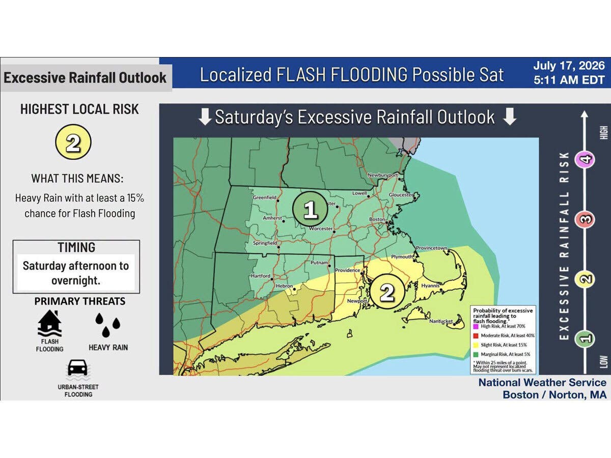
The likeliest timeframe is Saturday afternoon and into the overnight hours, and there will be the potential for street flooding, according to the National Weather Service.
The risk for severe weather is higher in southern Connecticut Saturday, where a hazardous weather outlook is in effect.
Find out what's happening in Across Connecticutfor free with the latest updates from Patch.
“Showers and thunderstorms are expected Saturday into Saturday evening,” the outlook says. “There is a slight risk for severe thunderstorms with the main threat damaging wind gusts. An isolated tornado cannot be ruled out. Heavy rainfall is also possible which may lead to isolated to scattered flash flooding."
WFSB is calling Saturday a “First Alert Weather Day,” due to the anticipated stormy weather in the afternoon and evening.
“While we certainly need rain, this round is poorly timed as it could impact outdoor activities, especially with a threat for stronger storms also in the mix through the afternoon and evening,” WFSB reports. “Poor drainage flooding will be possible in areas that see repeated downpours.”
WTNH says it is watching a “strong weather system for Saturday & Saturday night with some showers and storms.”
It predicts some storms could be “strong to severe along with a brief flash flooding risk.”
Read More:
- Dog Protecting Dead Owner Attacks Small Dog On Trail
- Pickup Truck Slams Into Building; Driver Hospitalized
- ‘Lost Everything’: Family Loses Everything In Fire
The National Weather Service predicts wildfire smoke will be impacting Connecticut again on Saturday too.
Better weather Sunday
Sunday will be the best day for outdoor activities, as the National Weather Service predicts sunny skies with high temperatures reaching between 78 and 82 degrees.
Here are the forecast details for northern Connecticut via the National Weather Service:
Today: Mostly sunny, with a high near 86. Northwest wind 6 to 9 mph.
Tonight: Areas of smoke. Partly cloudy, with a low around 59. West wind around 5 mph becoming calm in the evening.
Saturday: A chance of showers before 3 p.m., then a chance of showers and thunderstorms between 3 p.m. and 4 p.m., then showers likely and possibly a thunderstorm after 4 p.m. Some of the storms could produce heavy rainfall. Areas of smoke before 1 p.m. Increasing clouds, with a high near 83. Light south wind becoming southwest 11 to 16 mph in the morning. Winds could gust as high as 32 mph. Chance of precipitation is 60%. New rainfall amounts between a half and three quarters of an inch possible.
Saturday Night: Showers and possibly a thunderstorm before 2 a.m., then a chance of showers and thunderstorms between 2 a.m. and 3 a.m., then a chance of showers after 3 a.m. Some of the storms could produce heavy rainfall. Low around 66. Southwest wind 8 to 11 mph, with gusts as high as 25 mph. Chance of precipitation is 90%. New rainfall amounts between a half and three quarters of an inch possible.
Sunday: Sunny, with a high near 78. Northwest wind 11 to 14 mph.
Sunday Night: Mostly clear, with a low around 56. Northwest wind 5 to 7 mph becoming calm after midnight.
Here are the forecast details for southern Connecticut via the National Weather Service:
Today: Areas of smoke. Sunny, with a high near 85. North wind 5 to 7 mph becoming west in the afternoon.
Tonight: Patchy smoke. Partly cloudy, with a low around 68. Calm wind.
Saturday: Showers and possibly a thunderstorm, mainly after 2 p.m. Widespread smoke, mainly between 2 p.m. and 3 p.m. High near 79. Southwest wind 6 to 14 mph, with gusts as high as 28 mph. Chance of precipitation is 80%. New rainfall amounts between a quarter and half of an inch possible.
Saturday Night: Showers and possibly a thunderstorm before 2 a.m. Low around 69. Southwest wind 8 to 11 mph, with gusts as high as 22 mph. Chance of precipitation is 90%. New rainfall amounts between a half and three quarters of an inch possible.
Sunday: Sunny, with a high near 82. Northwest wind around 11 mph.
Sunday Night: Mostly clear, with a low around 62.
Get more local news delivered straight to your inbox. Sign up for free Patch newsletters and alerts.