Weather
Snow Accumulation Estimates Change For CT: Here Are The Latest Details, Timeline
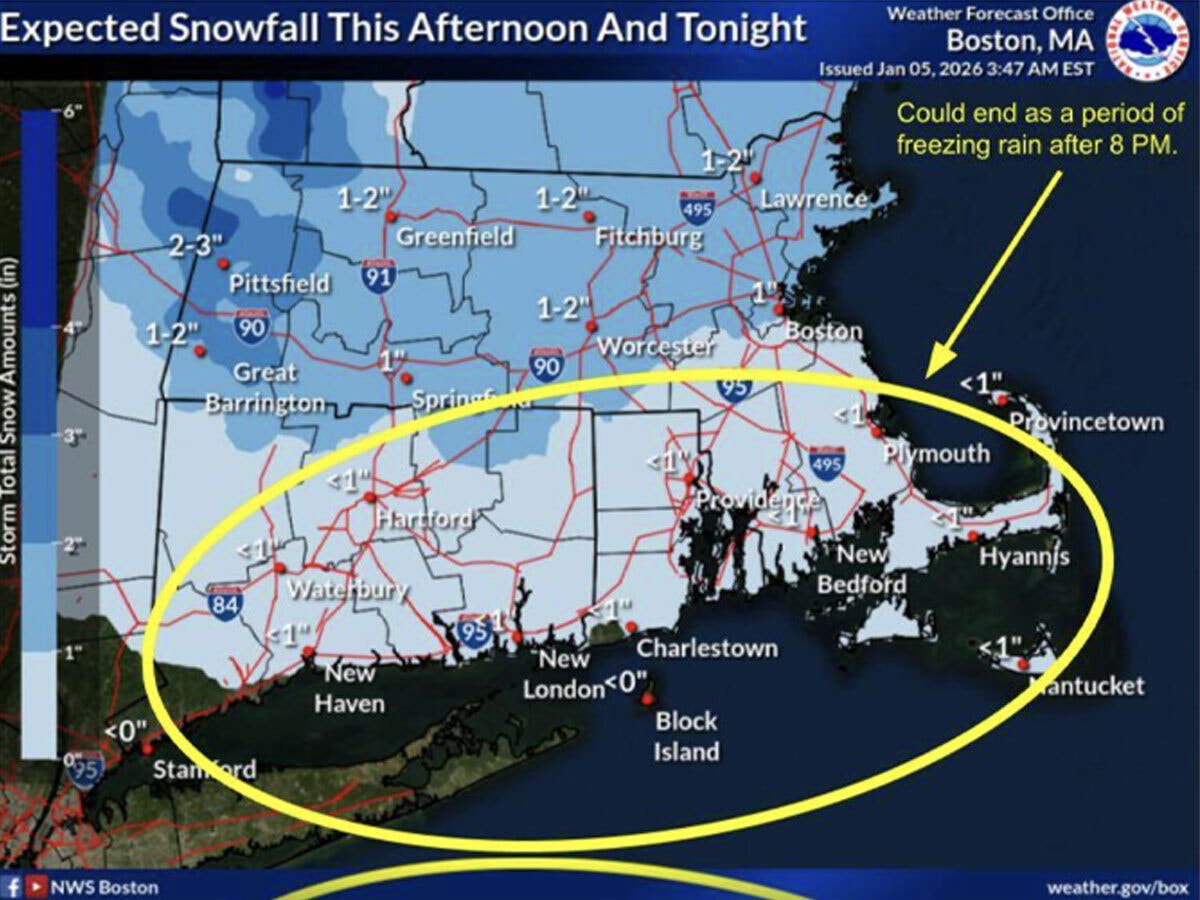
Freezing rain is possible in some areas, according to meteorologists.

Snow is expected to impact the state later today, potentially making for slick roadways for the evening commute.
While WFSB meteorologists had previously estimated the state could get up to two inches of snow, the station currently predicts less precipitation.
WFSB has cancelled Monday as a First Alert Weather Day due to the anticipated lighter snowfall.
Find out what's happening in Across Connecticutfor free with the latest updates from Patch.
The system arrives this afternoon and will bring snow showers, according to WFSB.
“Snow amounts should range from a coating to around two tenths of an inch, particularly in inland areas of the state,” WFSB reports.
Find out what's happening in Across Connecticutfor free with the latest updates from Patch.
Timeline for snow
The National Weather Service in Boston predicts light snow will develop between 1 p.m. and 3 p.m. today across western areas, and between 3 to 6 p.m. further east, with snow stopping before midnight.
The National Weather Service predicts most of Connecticut will get under an inch of snow, though parts of the state close to the Massachusetts border could get about an inch.
Icing concerns in parts of CT
The snow could transition to a period of freezing rain before the precipitation stops, according to the National Weather Service.
On Tuesday, WFSB anticipates it will be “quieter and milder” in Connecticut, with temperatures reaching into the upper 30s. The National Weather Service predicts southern Connecticut could see temperatures near 40 degrees Tuesday.
According to WFSB, there could be a brief wintry mix Tuesday night into early Wednesday, before the precipitation turns to rain.
Warmup fast approaching
WFSB reports high temperatures Wednesday through Friday will be in the 40s, making it feel “more like March than mid-January, though scattered showers may limit outdoor plans.”
The National Weather Service is forecasting the state could see high temperatures reach around 51 degrees on Friday.
Much warmer temperatures starting mid-week could provide an opportunity to take down outdoor holiday decorations currently buried in snow.
Read More:
- 2 Killed In Crash After Stolen Car Hits Tree, Police Say
- Prostitution Investigation Leads To Arrest of Female Employees of Spa Business: Police
- Pickup Truck Doing Donuts In Church Parking Lot Damages Stairs, State Police Say
Here are the forecast details for northern Connecticut via the National Weather Service:
Today: A chance of snow, mainly after 3 p.m. Cloudy, with a high near 28. Calm wind becoming south around 5 mph in the afternoon. Chance of precipitation is 40%. Total daytime snow accumulation of less than a half inch possible.
Tonight: A chance of snow and freezing rain before midnight, then a slight chance of freezing rain between midnight and 1 a.m. Cloudy, with a low around 23. Light and variable wind. Chance of precipitation is 50%. New snow accumulation of less than one inch possible.
Tuesday: A chance of rain, mainly after 5 p.m. Cloudy, with a high near 37. Light northeast wind. Chance of precipitation is 30%.
Tuesday Night: Rain or freezing rain, mainly before 4 a.m. Low around 32. Light and variable wind. Chance of precipitation is 80%. New precipitation amounts of less than a tenth of an inch possible.
Wednesday: A chance of rain, mainly before 8 a.m. Partly sunny, with a high near 43. Northwest wind 5 to 10 mph, with gusts as high as 20 mph. Chance of precipitation is 30%.
Wednesday Night: Partly cloudy, with a low around 28. Northwest wind 3 to 6 mph.
Thursday: Mostly sunny, with a high near 44. Calm wind becoming west around 5 mph in the afternoon.
Thursday Night: A chance of rain after 4 a.m. Mostly cloudy, with a low around 30. South wind 3 to 6 mph. Chance of precipitation is 30%.
Friday: Rain likely, mainly after 4 p.m. Cloudy, with a high near 51. South wind 6 to 9 mph. Chance of precipitation is 60%.
Here are the forecast details for southern Connecticut via the National Weather Service:
Today: A 30 percent chance of snow, mainly between 10 a.m. and 4 p.m. Cloudy, with a high near 35. Calm wind becoming south around 6 mph in the afternoon.
Tonight: A 20 percent chance of snow before 10 p.m. Cloudy, with a low around 27. South wind around 6 mph becoming calm in the evening.
Tuesday: Mostly cloudy, with a high near 40. Calm wind becoming east around 5 mph.
Tuesday Night: Rain likely, mainly before 1 a.m. Mostly cloudy, with a steady temperature around 38. East wind around 5 mph becoming light and variable. Chance of precipitation is 60%.
Wednesday: Mostly cloudy, then gradually becoming sunny, with a high near 46. West wind 7 to 10 mph, with gusts as high as 20 mph.
Wednesday Night: Mostly clear, with a low around 29.
Thursday: Mostly sunny, with a high near 45.
Thursday Night: Mostly cloudy, with a low around 34.
Friday: A 50 percent chance of rain. Mostly cloudy, with a high near 51.
Get more local news delivered straight to your inbox. Sign up for free Patch newsletters and alerts.