Weather
Strong Coastal Storm's Impacts On CT Revealed: Here's What You Need To Know
Find out what the forecast looks like for Valentine's Day, the long holiday weekend and beyond, according to meteorologists.

The latest forecast shows a coastal storm is expected to miss Connecticut, but meteorologists are continuing to monitor it closely.
Find out what's happening in Across Connecticutfor free with the latest updates from Patch.
Find out what's happening in Across Connecticutfor free with the latest updates from Patch.
WFSB also reports the latest models show the storm passing offshore from southern New England.
“Current thinking is that we’ll see an increase in cloudiness as it develops Sunday, then increasing sunshine Monday as it moves farther offshore,” WFSB reports. “We’re still several days out and will keep you updated if this changes!”
The National Weather Service as of Thursday is putting the chance of snow from Sunday night into Monday at 30 percent.
Valentine’s Day Planning
In the short term, both today and Friday are expected to be sunny, with highs in the mid-30s, according to the National Weather Service.
WFSB predicts the next chance for snowfall will be on Saturday morning, Valentine’s Day, with snow showers due to a “quick moving disturbance.” The National Weather Service is forecasting a chance of flurries Saturday morning before 11 a.m., followed by clearing and high temperatures around 40 degrees.
WTNH’s meteorologists predict it will be “very light snow” Friday night into early Saturday, with “a coating to maybe 1 inch.”
“Valentine’s afternoon and evening will be fine for your plans,” WTNH reports.
READ MORE:
- Famous Chef's Restaurant Temporarily Closes: Here's What’s Planned Next
- Former NFL Star Lists Antique Home For Sale At $8 Million
- Father Sentenced In His Infant Son's Bathtub Drowning Death
A Warming Trend
For the workweek next week, daytime temperatures will reach into the 40s, according to the National Weather Service.
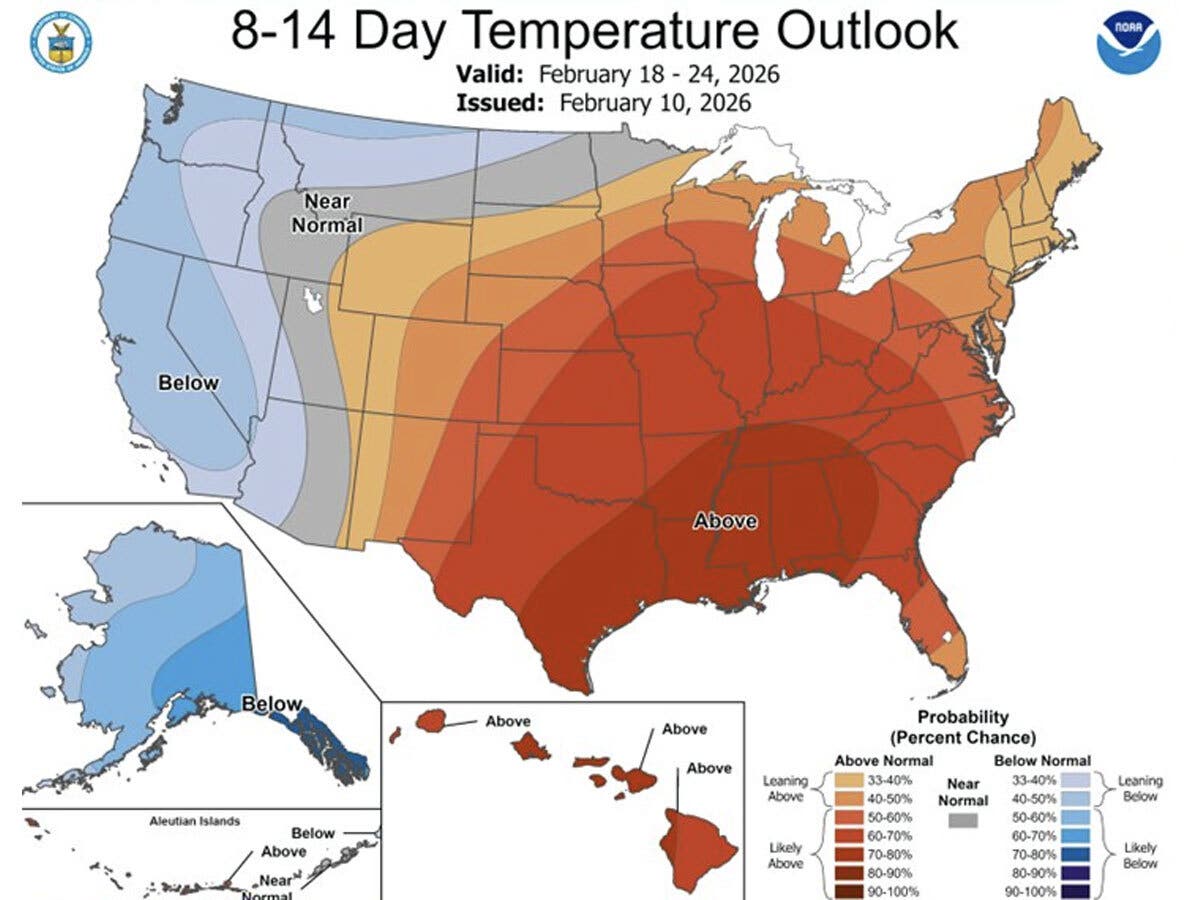
“If you are tired of the cold...good news, the Climate Prediction Center is forecasting a 33-40% chance of above normal temperatures for Feb 18-24!” the National Weather Service’s New York City office said.
Here are the forecast details for northern Connecticut via the National Weather Service:
Today: Mostly sunny, with a high near 34. Northwest wind 11 to 14 mph.
Tonight: Partly cloudy, with a low around 11. Northwest wind 6 to 9 mph.
Friday: Sunny, with a high near 36. North wind 5 to 8 mph.
Friday Night: A chance of flurries after 2 a.m. Increasing clouds, with a low around 15. West wind around 5 mph becoming calm in the evening.
Saturday: A chance of flurries before 11 a.m. Partly sunny, with a high near 41. Light and variable wind becoming northwest 5 to 10 mph in the morning. Winds could gust as high as 21 mph.
Saturday Night: Partly cloudy, with a low around 17. West wind around 6 mph.
Sunday: Partly sunny, with a high near 39. North wind around 6 mph becoming south in the afternoon.
Sunday Night: A chance of snow after 10 p.m. Mostly cloudy, with a low around 24. Southeast wind around 5 mph becoming north after midnight. Chance of precipitation is 30%.
Washington's Birthday: A chance of snow before noon, then a chance of rain between noon and 2 p.m. Partly sunny, with a high near 40. North wind 5 to 7 mph. Chance of precipitation is 30%.
Here are the forecast details for southern Connecticut via the National Weather Service:
Today: Mostly sunny, with a high near 35. Wind chill values between 15 and 25. Northwest wind 11 to 14 mph, with gusts as high as 25 mph.
Tonight: Mostly clear, with a low around 17. Wind chill values between 10 and 15. Northwest wind 6 to 8 mph.
Friday: Sunny, with a high near 35. Wind chill values between 10 and 20. Northwest wind 6 to 8 mph.
Friday Night: A 30 percent chance of snow showers, mainly after 10 p.m. Increasing clouds, with a low around 22. Calm wind.
Saturday: Mostly sunny, with a high near 40. Calm wind becoming west 5 to 9 mph in the morning.
Saturday Night: Partly cloudy, with a low around 23.
Sunday: Partly sunny, with a high near 38.
Sunday Night: A 30 percent chance of snow. Mostly cloudy, with a low around 27.
Washington's Birthday: Mostly sunny, with a high near 41.
Get more local news delivered straight to your inbox. Sign up for free Patch newsletters and alerts.