Weather
Thunderstorms Forecast For CT: Here's When, What To Know
Find out the latest weather prediction through the weekend, according to meteorologists.


After another pleasant and sunny day today, showers and potential thunderstorms are back in the forecast for Thursday.
The National Weather Service predicts today will continue to be mostly sunny, with highs in the upper 70s to low 80s, and low humidity.
That pattern changes Thursday, when scattered showers and storms are possible starting in the afternoon and into Friday.
Find out what's happening in Across Connecticutfor free with the latest updates from Patch.
“Summerlike humidity” is expected also, according to the National Weather Service.
“One more dry day is expected today before showers and thunderstorms return Thursday,” the National Weather Service said.
Find out what's happening in Across Connecticutfor free with the latest updates from Patch.
During the afternoon and evening Thursday, it predicts there is a potential for “isolated” severe thunderstorms.
The National Weather Service predicts any showers will start around mid-day Thursday, with the thunderstorm chance ramping up after 2 p.m. and lasting into Friday morning.
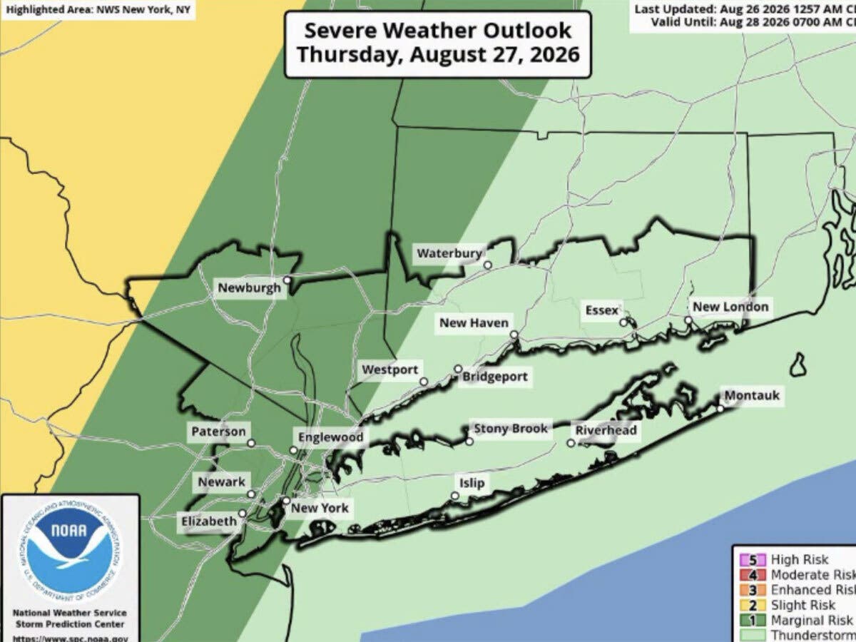
WFSB is calling the increase in humidity and the chance for precipitation the “Next Big Thing.”
“(On Thursday) dew point values go up to near oppressive levels and cloud cover increases,” WFSB reports. “Toward and after the evening commute, showers/storms will be possible.”
WFSB predicts any storms will first impact the western half of the state in the early afternoon, then move eastward. Its meteorologists caution we will be dealing with stormy weather Thursday afternoon and into the evening.
The National Weather Service predicts showers and thunderstorms may linger on Friday, followed by gradual clearing.
Looking ahead to the weekend, the National Weather Service anticipates both Saturday and Sunday will be sunny, with highs in the upper 70s to low 80s.
“As we see it now, the 5th weekend of the month looks fantastic with comfortable humidity and dry weather both days!” WFSB reports.
Read More:
- Woman Hit By Vehicle After Stopping To Help Motorists
- Teacher, 50, Charged After Investigation Revealed 'Inappropriate Contact With Student:' PD
- 7 Arrested In Child Predator Sting Operation: Police
Here are the forecast details for southern Connecticut via the National Weather Service:
Today: Sunny, with a high near 79. Light and variable wind becoming south 5 to 7 mph in the afternoon.
Tonight: Partly cloudy, with a low around 68. South wind 3 to 5 mph.
Thursday: A chance of showers between 11 a.m. and 2 p.m., then a chance of showers and thunderstorms after 2 p.m. Increasing clouds, with a high near 81. South wind 6 to 13 mph. Chance of precipitation is 50%.
Thursday Night: Showers likely and possibly a thunderstorm before 2 a.m., then a chance of showers and thunderstorms between 2 a.m. and 5 a.m., then a chance of showers after 5 a.m. Mostly cloudy, with a low around 67. South wind 5 to 8 mph becoming calm after midnight. Chance of precipitation is 60%. New rainfall amounts of less than a tenth of an inch, except higher amounts possible in thunderstorms.
Friday: A chance of showers, with thunderstorms also possible after 11 a.m. Partly sunny, with a high near 81. Calm wind becoming west around 6 mph in the afternoon. Chance of precipitation is 30%.
Friday Night: Mostly cloudy, with a low around 62.
Saturday: Mostly sunny, with a high near 77.
Saturday Night: Partly cloudy, with a low around 63.
Sunday: Sunny, with a high near 79.
Here are the forecast details for northern Connecticut via the National Weather Service:
Today: Mostly sunny, with a high near 81. Light and variable wind.
Tonight: Partly cloudy, with a low around 63. Light south wind.
Thursday: A chance of showers and thunderstorms after 2 p.m. Partly sunny, with a high near 83. Light south wind increasing to 9 to 14 mph in the morning. Winds could gust as high as 25 mph. Chance of precipitation is 40%. New rainfall amounts between a tenth and quarter of an inch, except higher amounts possible in thunderstorms.
Thursday Night: Showers likely and possibly a thunderstorm. Mostly cloudy, with a low around 65. South wind 5 to 10 mph becoming light after midnight. Winds could gust as high as 20 mph. Chance of precipitation is 70%. New precipitation amounts between a tenth and quarter of an inch, except higher amounts possible in thunderstorms.
Friday: A chance of showers, with thunderstorms also possible after 11 a.m. Partly sunny, with a high near 82. Calm wind becoming west around 5 mph in the afternoon. Chance of precipitation is 40%.
Friday Night: Partly cloudy, with a low around 59. North wind 3 to 6 mph.
Saturday: Sunny, with a high near 80. North wind 3 to 5 mph.
Saturday Night: Mostly clear, with a low around 57. Calm wind.
Sunday: Mostly sunny, with a high near 83. Calm wind becoming southwest 5 to 8 mph in the afternoon.
Get more local news delivered straight to your inbox. Sign up for free Patch newsletters and alerts.