Politics & Government
Safety Plans Follow State Rt. 146 Study On Traffic, Speeding, Crashes
Branford lawmakers laud state transportation dept. on its study, and praise community for input, now eye safety proposals for the roadway.

BRANFORD, CT —After getting input from local residents about traffic and safety concerns on the heavily travelled Route 146, state Sen. Christine Cohen (D-Guilford) and state Rep. Robin Comey (D-Branford) are "optimistic" about proposed road improvements.
The state Department of Transportation just released its road safety audit of a portion of the scenic roadway and offered plans for several safety-related road upgrades.
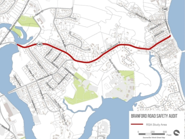
At the legislators' request, the DOT studied traffic along Route 146 in Branford between South Montowese Street and Sybil Avenue in order to improve safety for motorists, pedestrians and bicyclists travelling through the area. This stretch of Route 146 serves many purposes, including local residential access, restaurant and commercial business access, marina access, truck access to the sewage treatment plant, and pedestrian and bicyclist movement throughout the beach community, they said. The Shoreline Greenway Trail also runs through the northern end of the study area at Tabor Drive.
Find out what's happening in Branfordfor free with the latest updates from Patch.
According to the study, DOT found the average daily traffic in the area ranges from 3,100 vehicles per day at the southern end of the study area (Sybil Avenue, south of Linden Avenue) to as many as 9,400 vehicles per day in the middle of the study area along the commercial core, depending on the season.
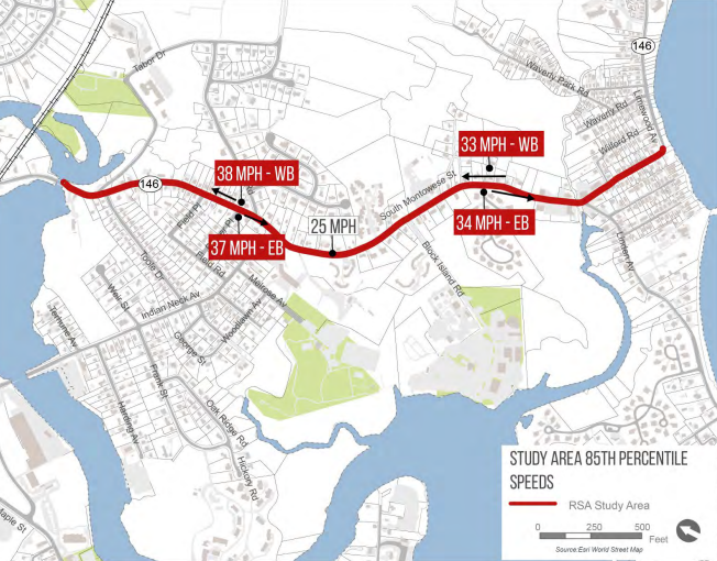
Traffic volumes are highest during summer months, late mid-week and on Saturdays. While the speed limits in the study area are 25 MPH, the DOT found that 85 percent of vehicular traffic along Route 146 actually travels 33-38 mph, with even higher speeds along the northern portion of the route, its study found.
Find out what's happening in Branfordfor free with the latest updates from Patch.
Also noted are these stats: There were 41 crashes along the corridor – including one fatal crash – in the five years from January 2016 to December 2020, with most crashes concentrated in the vicinity of Block Island Road, Linden Avenue and the commercial area, Toole and Tabor Drives, and Indian Neck Avenue.
DOT meetings with residents before conducting the study revealed several concerns with the Route 146 corridor, including:
- There is a lot of commercial activity by the marina on Block Island Road and south toward the restaurants and business area. This activity poses safety concerns, especially with late night bar traffic, etc.
- The Branford Housing Authority will be renovating its property and realigning sidewalks and driveways to the housing
- South Montowese Street has been a scenic road since the 1990’s, and although members of the scenic road committee recognize that safety is an issue, they feel that a balance is needed. Members believe recommendations should be focused on reducing speeds
- There is a need to make the area more attractive and safer for pedestrians and bicyclists to enjoy
- In the summer, traffic volumes increase due to tourism
- Sightlines at some driveways and intersections can be difficult in summertime due to vegetation growth
- Sightlines turning left onto Linden from Sybil Avenue (Route 146 northbound) is difficult due to poor sightlines around the horizontal curve to the north and the fast speeds of southbound traffic
Based on these concerns and others, DOT suggests improvements that include:
- Consider a 65-foot diameter decorative mini-roundabout at the intersection of Route 146 and Linden Avenue
- Continue to monitor the curve on Route 146 at Limewood Avenue following ongoing construction projects; consider in-lane curve markings
- Improving various pedestrian crossings, including the installation of decorative crosswalks
- Installation of sidewalks, especially in residential areas
- Installation of "pedestrian-scale lighting" near businesses, similar to that in Branford Center
- Re-striping various sections of roadway
- Relocating some utility poles
- Installing 2"x3" reflective roadside markers at four-foot heights to enhance nighttime visibility along some curves
- Trim or remove brush to improve sightlines
- Consider rapid flashing beacons on some crosswalks
Branford town officials are now expected to review the DOT report, decide which projects to prioritize and pursue, then work with Cohen and Comey on funding opportunities and the best path forward.
"As pedestrian, cyclist, and motor vehicle accidents increase in Connecticut and across the country, ensuring that our streets are safe for everyone is more important than ever. As we continue to connect neighborhoods with local businesses and residents with the open spaces and pastimes that they love, providing secure avenues is essential," Cohen said. After resident input, Cohen said officials "now have a good handle on traffic along Route 146 as well as ways to improve safety there."
"This has been and will continue to be a collaborative process working toward the best interests of the community," she noted.
Comey agreed. She said that with the transportation department "listening to safety concerns" and with its "thorough onsite field audit" it's come up with recommendations to improve access and overall safety for all travelers in this area.
“This great outcome is the result of the public’s input and our joint efforts to find a solution to this situation," Comey said. "I'm grateful to everyone involved in making this happen and look forward to exploring the next steps in the process.”
Here's the full CT DOT Rt. 146 report, with maps:
Get more local news delivered straight to your inbox. Sign up for free Patch newsletters and alerts.