Crime & Safety
Tracking Irene: Saturday Afternoon Hurricane Update
Irene is already beginning to affect the region.


Key takeaways:
- Worst weather tonight to midday Sunday
- 5 to 10+ inches of rain, major flooding
- Strong winds of 40 to 60 MPH sustained
- Wind damage will cause power outages
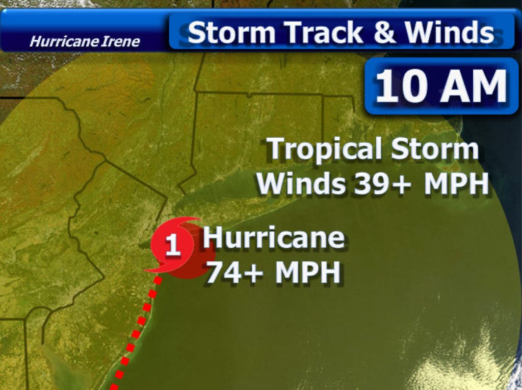
11 A.M. Storm Details: Hurricane Irene is a Category 1 storm with peak sustained winds of 85 miles per hour. The storm is moving north-northeast at 14 mph. The storm bringing hurricane conditions to North Carolina and Virginia. Since the storm is so large, New England is already getting hit by tropical downpours.
Tracking the storm: Irene will hug the mid-Atlantic coast through the rest of the day. The storm will move along the New Jersey coast and could be the first hurricane to make a direct landfall on the state since 1903.
Find out what's happening in Brookfieldfor free with the latest updates from Patch.
- The storm is expected to make landfall as a weak Category 1 hurricane over western Long Island and then move into Connecticut as a tropical storm.
Rest of today: Some outer bands from Irene will cause tropical thundershowers to move through. Many areas, especially around Danbury, Brookfield, Newtown, Bethel and New Milford have already seen over 1 to 2 inches of rain. The winds will still remain relatively light, but any isolated thunderstorm could feature gusty winds.
Tonight: A non-stop heavy rain moves in, with the heaviest rainfall occurring as you go further west in Connecticut. The intense rain will combine with foggy conditions and increasing winds. Winds of 15 to 30 MPH can be expected.
Find out what's happening in Brookfieldfor free with the latest updates from Patch.
Sunday morning: Stay inside and do not go out on the roads. Very heavy rainfall and strong thunderstorms will cause widespread flooding. Winds will increase to between 30 to 50 mph with stronger gusts. The storm center looks to make landfall in southwest Connecticut around noon. The heaviest rain falls along and west of the storm track, but stronger winds can be expected further eastward in Connecticut.
Sunday afternoon: The storm center passes right through Connecticut and winds increase to 40 to 60 mph, possibly gusting to hurricane force. The rain tapers off to scattered showers and we should see the rain suddenly come to an end. The sunshine may even break through the clouds as Irene races northward through New England.
Sunday night: Conditions clear out and dry up. Much cooler air is drawn in behind the departing storm, so temperatures fall back into the 50s overnight. It stays breezy, but even the winds subside towards Monday morning.
What to do now: Be ready for flooding tonight and power outages as early as Sunday morning due to increasing winds.
- If you have any cars, vehicles or other expensive items outside near trees, move them immediately. Strong winds will cause some branches, trees and even power lines to come down.
- If you live in a flood-prone area, it would be in your best interest to move to higher ground and stay with friends or family. Since roads may be closed tonight, leave as soon as possible if you plan to do so.
- Do not go out on the roads and do not go outside Sunday morning unless it is an emergency. There has already been at least one fatality from Irene - a tree fell on a person outside in the storm.
Reminders: Whether the storm is still a Category 1 hurricane or a "tropical storm" when it gets here does not make much difference. Flooding rainfall will happen and strong winds will cause some damage and power outages. It is better to be safe than sorry.
Comparing to Hurricane Gloria (1985): For those who remember this storm, expect conditions to be very similar. Gloria also moved into Long Island as a Category 1 hurricane and then passed through Connecticut. There were flooding rains and over 500,000 power outages across the state.
- If anything, this storm may be slightly worse than Gloria. Irene is a very large storm and even though it is weakening, it still has intense rainfall and a large area of strong winds.