Weather
Connecticut Weather: Tropical Storm Watch Issued For Parts Of The State
A new advisory has just been issued Sunday afternoon for the state as Hurricane Jose continues to move north. Here's the latest details.


A Tropical Storm Watch has just been issued for parts of Connecticut and new data and models Sunday indicate that the state is expected to see strong winds, periods of heavy rain and possible flooding conditions, especially late Tuesday and into Wednesday from Hurricane Jose.
On Friday, Connecticut was in the “cone of uncertainty,” which meant it was possible that Jose could make landfall somewhere in the state. But on Sunday, Connecticut is now out of the “cone of uncertainty” as Jose is expected to pass to the east of the state. Jose will pass close enough to Connecticut to cause tropical storm conditions for the state, especially the coast.
WTNH News 8 Meteorologist Gil Simmons, who returns to News 8 Monday, said Sunday afternoon that “New European model run has Wednesday power outages in Connecticut all over it. Not just shoreline either. 50+mph gusts.”
Find out what's happening in Darienfor free with the latest updates from Patch.
The @NWS has issued a Tropical Storm Watch for coastal Connecticut. Please monitor the forecast closely over the next few days.
— CTDESPP/DEMHS (@CTDEMHS) September 17, 2017
NBC Connecticut Meteorologist Ryan Hanrahan said Sunday afternoon that a “Tropical Storm Watch now in effect for coastal Connecticut and Long Island Sound.”
A tropical storm watch is now in effect for coastal Connecticut and Long Island Sound. #nbcct pic.twitter.com/ydr4JZlV2e
— Ryan Hanrahan (@ryanhanrahan) September 17, 2017
He added that most of the state could see winds approaching up to 40 mph at times, while areas in south eastern Connecticut could see wind gusts between 40 and 60 mph.
Find out what's happening in Darienfor free with the latest updates from Patch.
First cut at wind gust potential from #jose. Small wobbles in track will make big difference. #nbcct pic.twitter.com/la5aFTEQXA
— Ryan Hanrahan (@ryanhanrahan) September 17, 2017
“The strongest winds likely to be late Tuesday and early Wednesday,” Hanrahan wrote.
WTNH News 8 Meteorologist Kevin Arnone added that Jose “will bring coastal flooding, tropical storm force winds & rain to CT Tue/Wed as Maria barrels down on already damaged islands from Irma.”
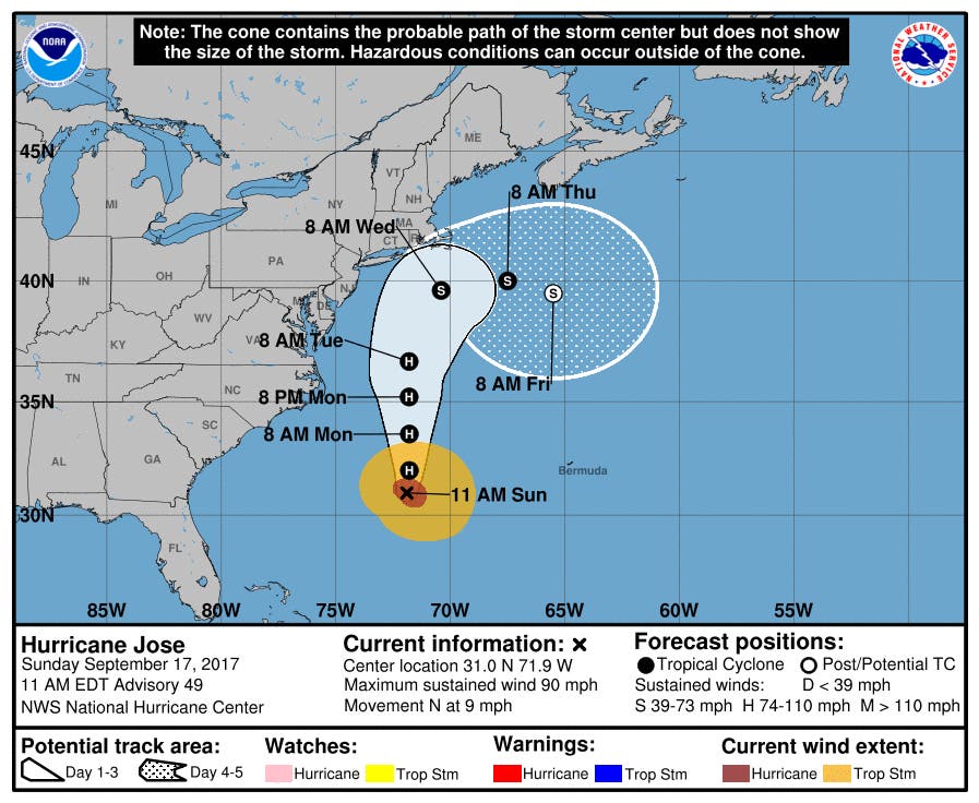
As of midday Sunday, Jose was located about 355 miles southeast of Cape Hatteras, N.C. It's currently a Category 1 hurricane with winds of 90 mph. Jose is expected to weaken into a tropical storm as it heads north and encounters cooler waters.
"While the center of Jose is currently forecast to remain offshore of the U.S. coast, the large cyclone could cause some direct impacts from Virginia northward to New England, and any deviation to the left of the NHC forecast track would increase the likelihood and magnitude of those impacts," the National Hurricane Center said.
See also: Racing Legend Ted Christopher Among 2 Killed In Connecticut Plane Crash
Here’s the updated forecast from the National Weather Service:
Tonight: Patchy fog after 1am. Otherwise, mostly cloudy, with a low around 64. East wind 5 to 7 mph.
Monday: Isolated showers. Mostly cloudy, with a high near 75. Northeast wind around 9 mph. Chance of precipitation is 20%.
Monday Night: A 50 percent chance of showers. Mostly cloudy, with a low around 66. Northeast wind 10 to 14 mph.
Tuesday: Showers likely. Cloudy, with a high near 73. Breezy, with a northeast wind 18 to 21 mph. Chance of precipitation is 70%. New precipitation amounts between a quarter and half of an inch possible.
Tuesday Night: Tropical storm conditions possible. Showers likely. Cloudy, with a low around 66. Chance of precipitation is 60%. New precipitation amounts between a quarter and half of an inch possible.
Wednesday: Tropical storm conditions possible. A 40 percent chance of showers. Mostly cloudy, with a high near 76.
Wednesday Night: A 30 percent chance of showers before midnight. Mostly cloudy, with a low around 64.
Get more local news delivered straight to your inbox. Sign up for free Patch newsletters and alerts.