Weather
CT Weather: Multiple Snow Chances in the Forecast
With the way April is beginning, would anyone be shocked to see snowflakes in May? No rest for the weather weary.


Mother Nature, this is no longer funny. Yes, accumulating snow is now possible on Friday and there could be another offshore storm later this weekend that could bring even more snow to Connecticut. While today will be much warmer than it has been, it will still feature rain, dangerous wind gusts and dense fog.
There are a number of advisories in effect for fog, wind and rain, which may include an isolated thunderstorm. "Mild conditions expected today with temperatures in the low to mid 60s as a warm front lifts north through the area. A cold front will approach from the west early this afternoon, bringing an increase chance of showers and isolated thunderstorms across the region," the National Weather Service states.
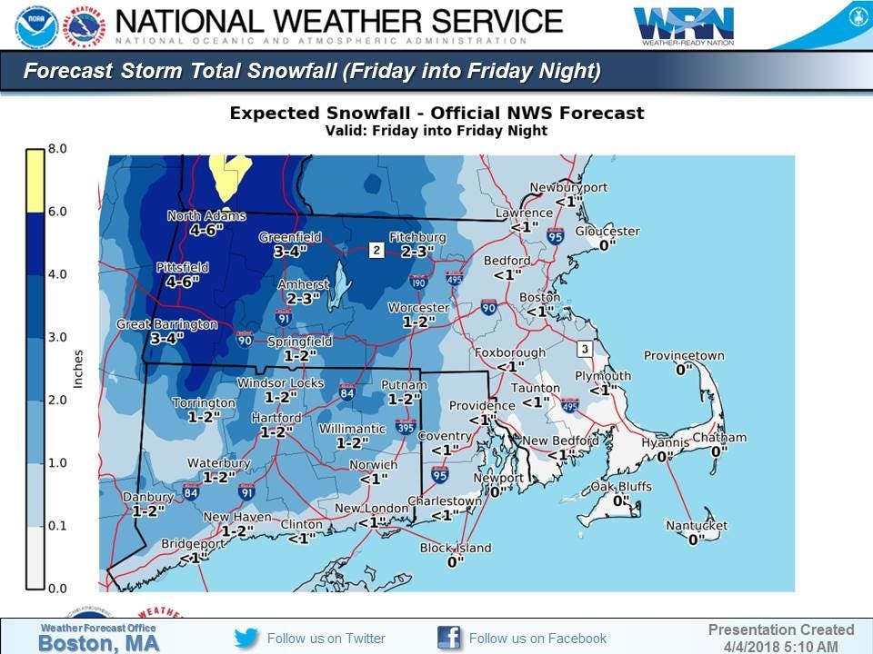
Strong gusty winds are expected this afternoon and evening, and temps will plummet to the freezing mark or below tonight. Winds could gust up to 50 mph at times. Thursday looks calm with sunshine and temps in the mid 40s before the expected arrival of more snow. It appears northern areas of the state may see the most snow as rain is likely to mix in along Southern Connecticut.
Find out what's happening in Greenwichfor free with the latest updates from Patch.
For areas in Litchfield, Hartford, Tolland, and Windham counties, the weather service says to expect accumulating snow Friday and possibly more snow later this weekend and early next week. Even areas in Southern Connecticut could see some accumulating snow.
Both the Friday morning snow and the Saturday snow chances looking more impressive. Plenty of "big" hits (for April) showing up on the European. pic.twitter.com/C2jCukTLXT
— Ryan Hanrahan (@ryanhanrahan) April 4, 2018
The overnight ECMWF EPS are strongly suggesting the potential for winter weather in the NYC region late this weekend - with the possibility of another notable snowfall. pic.twitter.com/AAX4ILQUjT
— John Homenuk (@jhomenuk) April 4, 2018
The National Weather Service in Boston has made its first guess on possible Friday snow accumulations.
Find out what's happening in Greenwichfor free with the latest updates from Patch.
"Speaking of Friday, considerably cold air in place of Arctic origin out ahead of a lifting warm front w/ a considerable moist punch; appreciable accumulating snows are possible for the Friday AM commute; our first guess forecast below ... aren't you excited!"
Here is the updated weather forecast for Southern Connecticut:
Today: Showers and possibly a thunderstorm before 3pm, then a chance of showers. Areas of fog before noon. High near 61. Breezy, with a southwest wind 5 to 10 mph increasing to 19 to 24 mph in the afternoon. Winds could gust as high as 40 mph. Chance of precipitation is 90%. New rainfall amounts between a tenth and quarter of an inch, except higher amounts possible in thunderstorms.
Tonight: Mostly clear, with a low around 32. Wind chill values between 25 and 30. Breezy, with a west wind 11 to 20 mph, with gusts as high as 41 mph.
Thursday: Sunny, with a high near 46. Wind chill values between 25 and 35 early. West wind 11 to 14 mph, with gusts as high as 26 mph.
Thursday Night: A chance of rain and snow, mainly after 3am. Increasing clouds, with a low around 32. Northwest wind 6 to 11 mph becoming light and variable after midnight. Chance of precipitation is 30%.
Friday: Rain and snow likely, becoming all rain after noon. Cloudy, with a high near 49. Breezy, with a southeast wind 10 to 15 mph becoming south 16 to 21 mph in the afternoon. Chance of precipitation is 70%. New snow accumulation of less than one inch possible.
Friday Night: A chance of rain before 2am, then a chance of rain and snow. Cloudy, with a low around 37. Chance of precipitation is 50%.
Saturday: A chance of rain and snow. Cloudy, with a high near 39. Chance of precipitation is 50%.
Saturday Night: A chance of rain and snow before midnight. Partly cloudy, with a low around 31. Chance of precipitation is 40%.
Here is the updated weather forecast for Northern Connecticut:
Today: Rain and thunderstorms likely before 3pm, then a chance of showers, mainly between 3pm and 5pm. Areas of fog before 1pm. Otherwise, cloudy, with a high near 65. Breezy, with a southwest wind 5 to 10 mph increasing to 15 to 20 mph in the afternoon. Chance of precipitation is 70%. New precipitation amounts between a tenth and quarter of an inch, except higher amounts possible in thunderstorms.
Tonight: Mostly clear, with a low around 29. Breezy, with a west wind 18 to 23 mph decreasing to 7 to 12 mph after midnight. Winds could gust as high as 50 mph.
Thursday: Sunny, with a high near 45. West wind 7 to 11 mph, with gusts as high as 25 mph.
Thursday Night: Increasing clouds, with a low around 26. West wind around 6 mph becoming light and variable in the evening.
Friday: Snow likely before 11am, then rain likely. Cloudy, with a high near 47. South wind 8 to 13 mph, with gusts as high as 30 mph. Chance of precipitation is 70%.
Friday Night: A chance of rain before 4am, then a slight chance of snow. Mostly cloudy, with a low around 33. Chance of precipitation is 30%.
Saturday: A chance of snow before 9am, then a chance of rain between 9am and 10am. Mostly cloudy, with a high near 41. Chance of precipitation is 30%.
Photo credit: Shutterstock
Get more local news delivered straight to your inbox. Sign up for free Patch newsletters and alerts.