Weather
New Details on Coastal Connecticut’s Tropical Storm Watch: Final Friday Update
The National Weather Service says the wind threat has increased and we'll give you the latest details on what is expected. BREAKING

A “Tropical Storm Watch” remains in effect for areas along the coast in Connecticut, including southern Fairfield, New Haven, Middlesex, and New London counties.
But in an evening update, the National Weather Service is cautioning residents along the coast that the “wind threat has increased” from the assessment earlier on Friday.
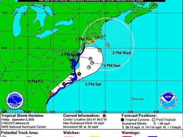
Originally, gusts up to 35 mph were expected on Sunday and Monday as Hermine moved to the south of Connecticut, but the National Weather Service now says gusts may approach speeds of 58 to 73 mph. This increases the chances for power outages and possibly property damage.
Find out what's happening in Greenwichfor free with the latest updates from Patch.
WTNH News 8 Meteorologist Gil Simmons said on social media that “I do expect power outages at shoreline and coastal flooding at high tide. Roughest weather Sunday midday-Monday AM.”
In the earlier advisory, the weather service predicted storm surge to be around 2-4 feet above ground, which still holds in the updated weather advisory.
Find out what's happening in Greenwichfor free with the latest updates from Patch.
And while people often associate tropical storms with heavy rain, this doesn’t appear to be a huge rainmaker for southern Connecticut. In fact, a total of 1 to 3 inches rain is possible.
Minor flooding concerns are possible, the weather service states, but adds that flooding doesn’t appear to be a huge concern.
Governor Dannel P. Malloy, in a statement, is asking shoreline residents to closely monitor Tropical Storm Hermine over the next several days and be prepared for potential minor to moderate flooding and some gusty winds. Residents should also be prepared in case potential power outages occur.
“Our office is receiving real-time updates on this storm and its path. Just as the state is monitoring and preparing, the public should do the same, especially residents in our shoreline communities,” Governor Malloy said in a statement Friday.
“Based on Hermine’s current projected path, we do not believe it will have a major impact on the state, but it does have the potential to produce some gusty winds and minor to moderate coastal flooding, especially in low-lying areas along the shoreline. Power outages are also a possibility with this storm. This storm needs to be watched closely over the next three to four days," Malloy said.
The Connecticut Department of Emergency Services and Public Protection’s Division of Emergency Management and Homeland Security (DEMHS) is monitoring this storm very closely and is prepared to coordinate any potential state response, Malloy said in his statement. DEMHS is participating in regular National Weather Service conference calls to get the latest information on the storm’s track and any potential impacts on the state, the Governor added.
See also: Meteorologist Geoff Fox Diagnosed with Cancer
The Latest on Hermine’s Path:
The National Weather Services says Hermine is forecast to move northeast of the Mid-Atlantic Coast and then slow down or even stall off the coast later Sunday into Monday.
A Tropical Storm Watch is in effect for Long Island, New York City, parts of New Jersey, coastal Connecticut and southern Westchester County.
“Sustained tropical storm force winds are possible in these areas,” the National Weather Service states.
Storm surge will be a concern around the time of high tide from Sunday onward, the weather service states.
The latest information on timing:
There is only a 20-percent chance of showers after midnight on Saturday. On Sunday, there is a 30-percent chance of rain during the day and mostly cloudy skies.
It appears the action gets going on Sunday night, which is when the rain and wind starts to pick up. As of right now, Labor Day appears to largely be a washout with “tropical storm conditions possible,” according to the weather service.
The possible tropical conditions continue through Tuesday night as the storm appears to stall off of the coast.
Get more local news delivered straight to your inbox. Sign up for free Patch newsletters and alerts.