Weather
Connecticut Weather: Snow Accumulation Estimates Released
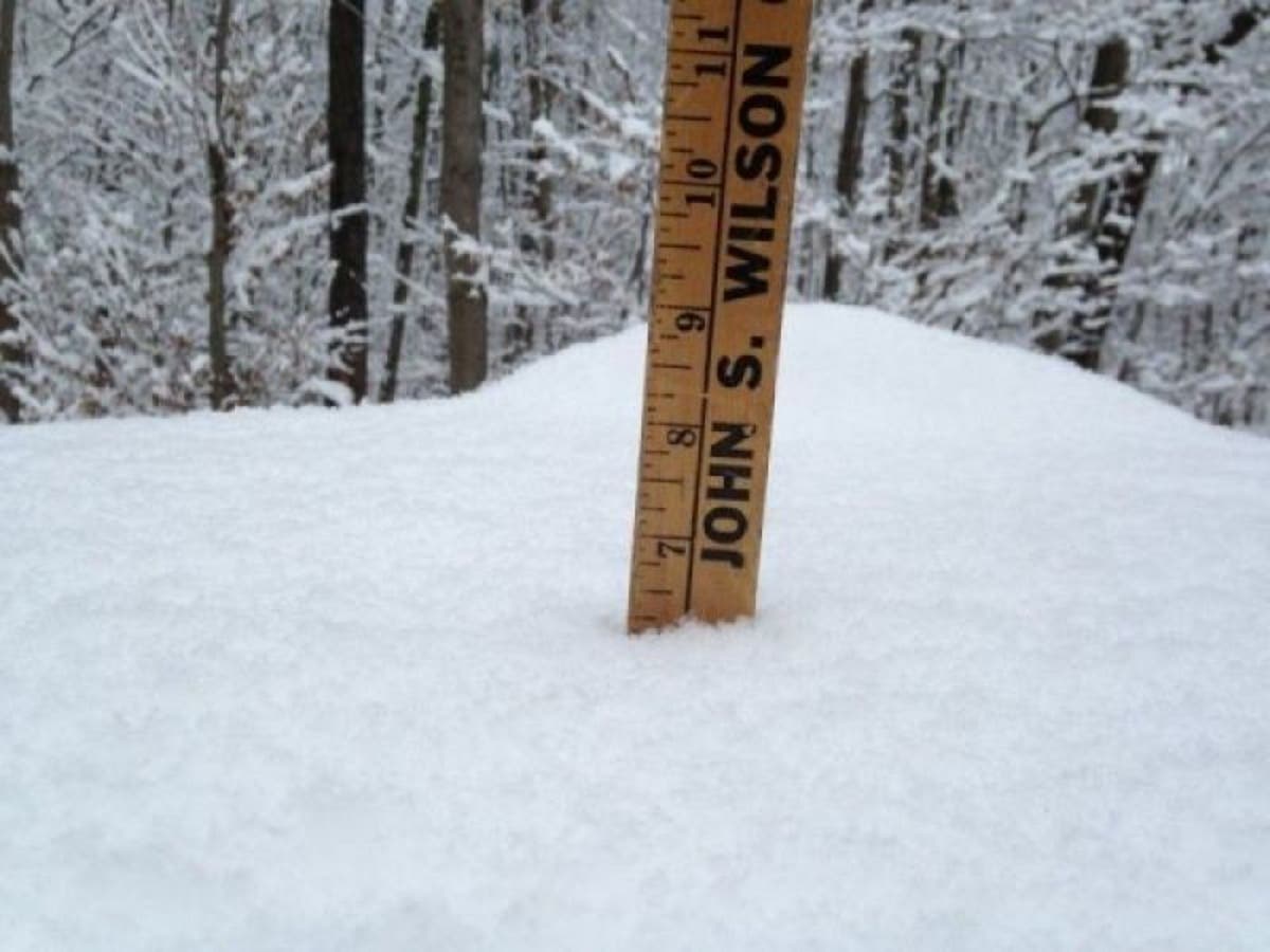
There are new changes to the midweek snowstorm and the National Weather Service released snow accumulation estimates Monday.

It now appears that colder air is going to win out on Wednesday which means the chances of accumulating snow are increasing for Connecticut, even at the immediate coast. The National Weather Service is now predicting accumulating snow for all of Connecticut. Snow is still expected to change to a mix during the day on Wednesday but not before there is some accumulation and after a period of mixing or even rain, the precipitation could end as snow.
NBC Connecticut Meteorologist Ryan Hanrahan said, "Our computer models are trending colder with the Wednesday storm and that means snow!"
WTNH News 8 Meteorologist Gil Simmons said, "Watch your step out there with some patchy ice around. Bright skies & a cold wind through the afternoon. Dress for 20! Quiet with clouds tomorrow followed by snow Wednesday. Eventually changing to or mixing with ice & rain. Could be school issues!!!"
Find out what's happening in Greenwichfor free with the latest updates from Patch.
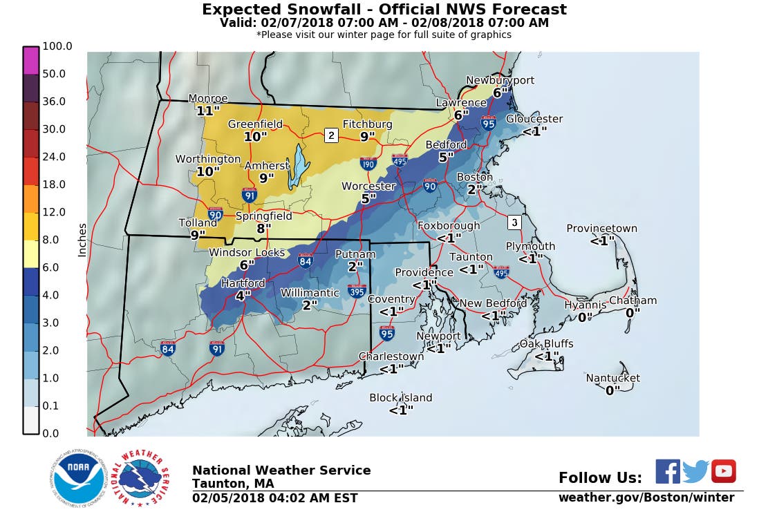
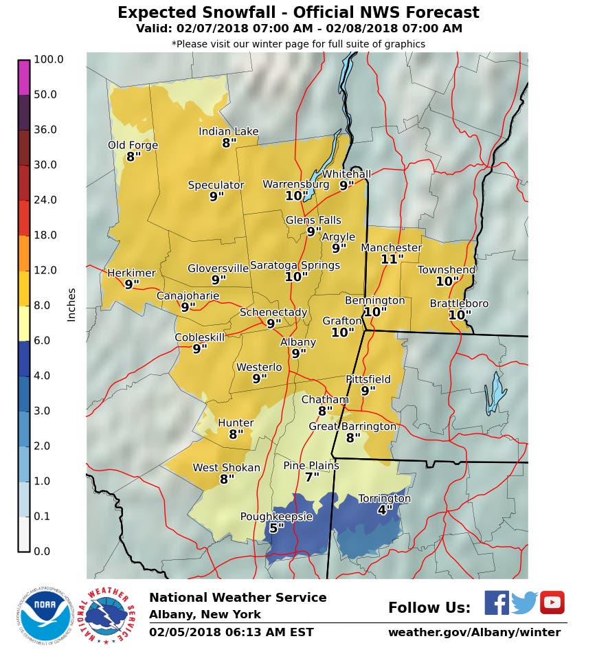
Currently, the Natonal Weather Service is predicting 1 to 2 inches of snow for the immediate Connecticut coast, 2 to 4 inches for inland areas of Fairfield, New Haven, Middlesex, and New London counties, and between 4 to 6 inches possibly for northern parts of Connecticut including Hartford, Tolland and Litchfield counties.
Find out what's happening in Greenwichfor free with the latest updates from Patch.
Reality TV Star Arrested; Gourmet Doughnuts Cause Stir: CT News
Snow forecast for the Connecticut coast:
Tuesday Night: A 20 percent chance of snow after 3am. Increasing clouds, with a low around 26. West wind 5 to 7 mph becoming northeast after midnight.
Wednesday: Snow before 1pm, then rain. High near 39. Southeast wind 7 to 11 mph. Chance of precipitation is 100%. New snow accumulation of 1 to 2 inches possible.
Wednesday Night: Rain before 1am, then a chance of snow and sleet between 1am and 5am. Low around 28. Chance of precipitation is 90%. New snow and sleet accumulation of less than a half inch possible.
Snow forecast for inland sections of Southern Connecticut:
Tuesday Night: A 20 percent chance of snow after 3am. Increasing clouds, with a low around 22. Light and variable wind becoming northeast around 5 mph after midnight.
Wednesday: Snow before 1pm, then rain. High near 36. Light northeast wind becoming east 5 to 9 mph in the morning. Chance of precipitation is 100%. New snow accumulation of 1 to 2 inches possible.
Wednesday Night: Rain and snow before 1am, then a chance of snow and sleet between 1am and 5am, then a chance of sleet after 5am. Low around 26. Chance of precipitation is 90%. New snow and sleet accumulation of 1 to 3 inches possible.
Snow forecast for Hartford County:
Wednesday: Snow, mainly after 11am. High near 34. Light and variable wind becoming east 5 to 7 mph in the morning. Chance of precipitation is 100%.
Wednesday Night: Rain before 2am, then a slight chance of rain and snow between 2am and 3am, then a slight chance of snow after 3am. Low around 26. Chance of precipitation is 90%.
Snow forecast for Tolland County:
Wednesday: Snow, mainly after 9am. High near 33. East wind 5 to 10 mph. Chance of precipitation is 100%.
Wednesday Night: Rain before midnight, then rain and snow likely between midnight and 1am, then a chance of snow after 1am. Low around 24. Chance of precipitation is 100%.
Snow forecast for Litchfield County
Tuesday Night: A slight chance of snow showers after 1am. Increasing clouds, with a low around 20. West wind around 5 mph becoming calm in the evening. Chance of precipitation is 20%.
Wednesday: Snow before 4pm, then rain, snow, and sleet. High near 33. Light and variable wind becoming southeast 5 to 10 mph in the morning. Chance of precipitation is 100%. New precipitation amounts between a quarter and half of an inch possible.
Wednesday Night: Rain, snow, and sleet before 7pm, then rain and snow between 7pm and 1am, then snow likely after 1am. Low around 19. Chance of precipitation is 90%. New precipitation amounts between a quarter and half of an inch possible.
Get more local news delivered straight to your inbox. Sign up for free Patch newsletters and alerts.


